River Chet
| Chet | |
| River | |
 | |
| Country | England |
|---|---|
| Region | Norfolk |
| Part of | River Yare |
| Source | |
| - location | Poringland |
| - elevation | 33 m (108 ft) |
| - coordinates | 52°33′30″N 1°20′47″E / 52.5584°N 1.3465°E |
| Mouth | River Yare |
| - elevation | 0 m (0 ft) |
| - coordinates | 52°33′19″N 1°32′25″E / 52.5554°N 1.5404°ECoordinates: 52°33′19″N 1°32′25″E / 52.5554°N 1.5404°E |
| Length | 16.5 km (10 mi) |
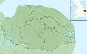 Location of the river mouth within Norfolk | |
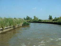
The River Chet is a small river in South Norfolk, England, a tributary of the River Yare. It rises in Poringland and flows eastwards through Alpington, Bergh Apton, Thurton and Loddon. At Loddon it passes under the A146 through Loddon Mill and into Loddon Staithe. From this point onwards the river is navigable. It then passes Hardley Flood to the north, a nature reserve part-managed by the Norfolk Wildlife Trust. The river finally joins the River Yare one mile west of Reedham at Hardley Cross, erected in 1676,[1] which marks the ancient boundary between the City of Norwich and the Borough of Great Yarmouth. The total navigable length is some 3½ miles.[2] Fishing is permitted between Loddon and Hardley Cross, bream and roach being the most common catch.[3]
|
|
References
External links
- Chet Valley Development Partnership
- River Chet cruising guide
- Hardley Flood
- A walk along the River Chet - From Loddon Staithe to Hardley Cross