Hacıbektaş
| Hacıbektaş | |
|---|---|
| District | |
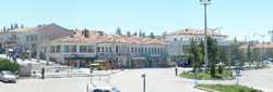 A panorama of Hacıbektaş | |
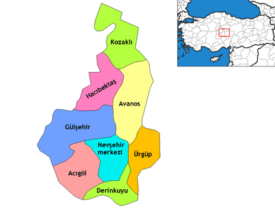 Location of Hacıbektaş within Turkey. | |
 Hacıbektaş Location of Hacıbektaş within Turkey. | |
| Coordinates: 38°57′N 34°34′E / 38.950°N 34.567°E | |
| Country |
|
| Region | Central Anatolia |
| Province | Nevşehir |
| Government | |
| • Governor | Mustafa Eldivan |
| • Mayor | Ali Rıza Selmanpakoğlu (Independent) |
| Area[1] | |
| • District | 696.69 km2 (268.99 sq mi) |
| Elevation | 1,250 m (4,100 ft) |
| Population (2012)[2] | |
| • Urban | 5,211 |
| • District | 11,615 |
| • District density | 17/km2 (43/sq mi) |
| Time zone | UTC+2 (EET) |
| • Summer (DST) | UTC+3 (EEST) |
| Postal code | 50xxx |
| Area code(s) | 0384 |
| Licence plate | 50 |
| Climate | Csb |
| Website | www.hacibektas.gov.tr |
Hacıbektaş, formerly Karahöyük, is a town and district of Nevşehir Province in the Central Anatolia region of Turkey. According to 2000 census, population of the district is 11,929 of which 5,169 live in the town of Hacıbektaş.[3][4] Located in Cappadocia, the district covers an area of 697 km2 (269 sq mi),[5] and the average elevation is 1,250 m (4,101 ft), with the highest point being Mt. Kırlangıç at 1,720 m (5,643 ft).
History
Hacıbektaş was in the Chamanene prefecture created by Archeläus of Cappadocia during Hellenistic times[6]
During the Roman Empire Hacıbektaş was the site of the town of Doara, though Ramsay identified Doara with Mudjur or Hadji Bektash. The town appears on the Peutinger Table between Caesarea and Tavium.[7] It was also mentioned by Heiroclese, and the Byzantine notiea.
Doara became the seat of a Bishopric in the 373, as part of the conflict between Anthimus, bishop of Tyana and Basil of Caesarea, as the town was between these two bishoprics. In 383 the bishop Bosporius was accused of heresy and although originally a suffran of the bishop in Tyana, in 436 Justinian placed the bishop under the bishop of Mokissos.
Notable residents
Haji Bektash Veli, the founder of the Bektashi order, lived in the area in the 14th century and is commemorated by the town's current name and in an annual festival. His tomb known as the Hajibektash complex is located near the center of town in his former monastery, now a museum, and is a site of pilgrimage for Alevi and Bektashi from throughout Turkey and the world.[8]
See also
Notes
- ↑ "Area of regions (including lakes), km²". Regional Statistics Database. Turkish Statistical Institute. 2002. Retrieved 2013-03-05.
- ↑ "Population of province/district centers and towns/villages by districts - 2012". Address Based Population Registration System (ABPRS) Database. Turkish Statistical Institute. Retrieved 2013-02-27.
- ↑ Statistical Institute
- ↑ GeoHive. "Statistical information on Turkey's administrative units". Retrieved 2008-04-15.
- ↑ Statoids. "Statistical information on districts of Turkey". Retrieved 2008-04-15.
- ↑ Strabo, Geography 12.1.4.
- ↑ W. M. Ramsay, The Historical Geography of Asia Minor (Cambridge University Press, 2010)p297-300.
- ↑ "Alevi figure Hacı Bektaş Veli commemorated in Nevşehir festival". Today's Zaman. Archived from the original on 2013-10-20.
References
- Falling Rain Genomics, Inc. "Geographical information on Hacıbektaş, Turkey". Retrieved 2008-04-15.
- Kenthaber.com. "General information on Hacıbektaş, Nevşehir" (in Turkish). Archived from the original on 2011-09-28. Retrieved 2008-04-15.
- Hacibektas.com. "Geographical and economical structure of Hacıbektaş, Nevşehir" (in Turkish). Retrieved 2008-04-15.
External links
- District governor's official website (in Turkish)
- District municipality's official website (in Turkish)
- Map of Hacıbektaş district
- Administrative map of Hacıbektaş district Website
Coordinates: 38°56′37″N 34°33′35″E / 38.94361°N 34.55972°E