Guiren District
Coordinates: 22°58′N 120°17′E / 22.967°N 120.283°E
| Gueiren 歸仁區 Guiren | |
|---|---|
| District | |
| Gueiren | |
 | |
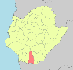 Gueiren District in Tainan City | |
| Country | Taiwan |
| Special municipality | Tainan |
| Gueiren Village | 1920 |
| Government | |
| • District Chief | Chen Ying-yu (陳英裕) |
| Area | |
| • Total | 55.7913 km2 (21.5411 sq mi) |
| Population (January 2016) | |
| • Total | 67,922 |
| • Density | 1,200/km2 (3,200/sq mi) |
| Time zone | UTC+8 (CST) |
| ZIP code | 711 |
| Website | www.gueiren.gov.tw |
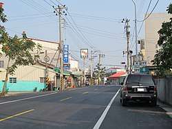
Gueiren District (Chinese: 歸仁區; Hanyu Pinyin: Guīrén Qū; Tongyong Pinyin: Gueirén Cyu; Wade–Giles: Kui1-jen2 Ch'ü1; Pe̍h-ōe-jī: Kui-jîn-khu) is a rural district in southern Tainan, Taiwan.
History
Before 25 December 2010, Gueiren used to be a township of Tainan County. After 25 December 2010, it was upgraded to be a district of the newly formed Tainan municipality.
Economy
The local economy is based mainly on agriculture, including sugar-apples, peanuts, starfruit and guavas.[1] It also houses the Shalun Smart Green Energy Science City.
Education
Tourist attractions
- Gueiren Excellencies Temple
- Lobster Pool
- Renshou Temple
- Temple of Confucius
- World Snake Educational Farm[2]
Transportation
Notable natives
- Lee Ming-liang, Minister of Department of Health (2000-2002)
See also
References
- ↑ "產業概況". 歸仁區公所. Retrieved 2011-01-23.
- ↑ http://web1.tainan.gov.tw/NewEnglish/CP/12376/Gueiren-1.aspx
External links
| Wikimedia Commons has media related to Gueiren District, Tainan. |
| Districts | .svg.png) | |
|---|---|---|
Note: Although Hanyu Pinyin is the national standard, Tainan names most of its districts by Tongyong Pinyin. East, South, West Central, and North district uses English instead. | ||
This article is issued from
Wikipedia.
The text is licensed under Creative Commons - Attribution - Sharealike.
Additional terms may apply for the media files.