Grafton Bridge (New South Wales)
| Grafton Bridge | |
|---|---|
 View of Grafton Bridge from the north bank of the Clarence River, August 2005 | |
| Coordinates | 29°41′52.6″S 152°56′31.5″E / 29.697944°S 152.942083°ECoordinates: 29°41′52.6″S 152°56′31.5″E / 29.697944°S 152.942083°E |
| Carries | Motor vehicles, railway line, water supply, pedestrians |
| Crosses | Clarence River |
| Locale | Grafton, New South Wales, Australia |
| Maintained by | Roads and Maritime Services, NSW Government |
| Characteristics | |
| Design | Bascule bridge |
| Material | Steel |
| Piers in water | 7 concrete[1] |
| Clearance above | 38 feet (12 m)[1] |
| Clearance below | 11 feet (3.4 m)[1] |
| History | |
| Constructed by | NSW Public Works |
| Construction start | 1922 |
| Construction end | 1932 |
| Construction cost | £500,000[1] |
| Inaugurated | 19 July 1932[1] |
Grafton Bridge is a bascule bridge which spans the Clarence River in Grafton, New South Wales, Australia. It links the main townsite with South Grafton, and carries the North Coast railway line (part of the Sydney–Brisbane rail corridor). It was added to the New South Wales State Heritage Register on 2 April 1999.[2]
History
A bridge over the Clarence River in Grafton was first conceived in 1915. The original design called for a railway bridge with a footway, but in 1922 the design was changed to accommodate vehicular traffic as well. The bridge was built from 1927 to 1932, although planning for the bridge had been underway as early as 1921. The bridge was designed and built by the New South Wales Public Works Department with steelwork from Clyde Engineering. The department decided to construct the bridge itself after being unhappy with the high cost proposed by private tenderers for the project.[3] It was formally opened by Governor-General of Australia Sir Isaac Isaacs on 19 July 1932.[4]
Design and features
The upper level of the bridge supports a two way road for traffic via Bent Street (Summerland Way), and its lower level supports a rail bridge that carries the North Coast railway line, a water main, and footbridges on either side.
There is provision for a second track across the bridge but at this time it is being used as an easement for a water main.[5]
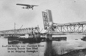
The bascule span was operational from its opening in 1932 until 1969.[6] The bascule can no longer be raised due to an added water main. With the decline in shipping along the Clarence River, the opening span was sealed shut and it can no longer be opened.
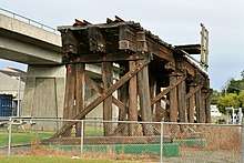
The bridge heritage listing also includes the three remnant spans of the 1915 timber viaduct south of Grafton railway station, which now remain in situ amidst parkland.[2][7]
Additional crossing of the Clarence River
In 2002, the Government of New South Wales commissioned a study into an additional crossing, released in early 2003.[5]
In October 2008, federal, state and local government representatives inspected the bridge, together with officials from Roads and Maritime Services (RMS). It was claimed that the existing bridge was not coping with the increasing volume of traffic. Estimates of replacing the bridge were in the range of A$100 million.[8] In December 2012, RMS announced that a preferred option of an additional crossing of the Clarence River had been identified and went on public display for comment. RMS also announced that a final decision is expected during 2013.[9]
Heritage listing
This bridge is a double-deck road/rail structure, the only one of its type in New South Wales. There is a lift span to allow passing of river traffic (no longer used). It presents a commanding visual reminder of rail and road to residents of Grafton. Opening of the bridge in 1932 completed the North coast standard gauge line between Sydney and Brisbane, avoiding the winding route via Tenterfield.[2]
The viaduct along with the wharf remains are important relics of the development of the north coast railway. The viaduct is representative of similar structures constructed at a range of locations, many of which have been replaced.[2]
Grafton Rail and Road Bridge over Clarence River was listed on the New South Wales State Heritage Register on 2 April 1999 having satisfied the following criteria.[2]
The place possesses uncommon, rare or endangered aspects of the cultural or natural history of New South Wales.
This item is assessed as historically rare. This item is assessed as scientifically rare. This item is assessed as arch. rare. This item is assessed as socially rare.[2]
References
- 1 2 3 4 5 McLennan, Maxwell (19 July 1932). "Grafton Bridge: Today's opening". The Sydney Morning Herald. National Library of Australia. Retrieved 16 March 2013.
- 1 2 3 4 5 6 "Grafton rail and road bridge over Clarence River, New South Wales State Heritage Register (NSW SHR) Number H01036". New South Wales State Heritage Register. Office of Environment and Heritage. Retrieved 2 June 2018.
- ↑ "Grafton rail and road bridge over Clarence River". State Heritage Inventory. Office of Environment and Heritage. Retrieved 30 June 2018.
- ↑ "GRAFTON BRIDGE". The Telegraph. Queensland, Australia. 26 May 1932. p. 9 (FIRST EDITION). Retrieved 30 June 2018 – via National Library of Australia.
- 1 2 "Additional Crossing of the Clarence River: Feasibility Study Report" (PDF). NSW Roads and Traffic Authority. February 2003. ISBN 0731053702. Retrieved 16 March 2013.
- ↑ Hauff, Maria (13 June 2007). "Grafton Bridge turns 75". ABC News. Australia: Australian Broadcasting Corporation. Retrieved 16 March 2013.
- ↑ "Railway Timber Viaduct". State Heritage Inventory. Office of Environment and Heritage. Retrieved 30 June 2018.
- ↑ "Funding doubts over second Grafton bridge". ABC News. Australia. 31 October 2008. Retrieved 16 March 2013.
- ↑ "Additional crossing of the Clarence River at Grafton: Recommended preferred option display" (PDF). Community update. Roads and Maritime Services. December 2012. Retrieved 16 March 2013.
Attribution
![]()