Ballina, New South Wales
| Ballina New South Wales | |||||||||
|---|---|---|---|---|---|---|---|---|---|
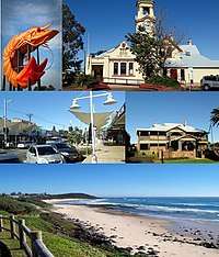 Clockwise from top left: The Big Prawn, Ballina Court House, Ballina Manor, Shelly Beach, River Street Mall. | |||||||||
|
Ballina | |||||||||
| Coordinates | 28°50′0″S 153°32′0″E / 28.83333°S 153.53333°ECoordinates: 28°50′0″S 153°32′0″E / 28.83333°S 153.53333°E | ||||||||
| Population | 24,852 (2016 census)[1] | ||||||||
| Established | 1840s | ||||||||
| Postcode(s) | 2478 | ||||||||
| Elevation | 1.3 m (4 ft)[2] | ||||||||
| Location | |||||||||
| LGA(s) | Ballina Shire | ||||||||
| State electorate(s) | Ballina | ||||||||
| Federal Division(s) | Richmond | ||||||||
| |||||||||
Ballina /ˈbælɪnə/[3] is a town in the Northern Rivers region of New South Wales, Australia, and the seat of the Ballina Shire local government area. Ballina's urban population at the 2016 census was almost 25,000[1]. The town lies on the Richmond River and serves as a gateway to Byron Bay.
Etymology
Ballina's etymology is not entirely certain. One view holds that it is a corruption of a clan name for the Bullina band of the Arakwal.[4] It has been argued that in this tribe's Bundjalung language, bullinah meant "place of many oysters". This theory argues that the Aboriginal name reminded the predominantly Irish settlers of "Ballina", so the name's origin could be an accidental or deliberate corruption of the Aboriginal form. Another view is that towns's name comes from the Irish placename Ballina (Béal an Átha, "mouth of the ford"), which is found in several parts of Ireland.
History
Ballina was established in the 1840s on the northern shore of the Richmond River near Cape Byron, Australia's most easterly point. A lighthouse, Richmond River Light, was first constructed in Ballina in 1866, which served as a significant port in the region. The temporary lighthouse was replaced with the current one, designed by James Barnet, in 1879, and first lit in 1880. It is still active.[5] A branch railway line connected Ballina with the Murwillumbah railway line railway at Booyong. The line was opened on 24 August 1930 and closed on 12 January 1949.[6]
Landfalls
Ballina has a number of famous "landfalls" associated with it. In 1928, Charles Kingsford Smith's plane, the Southern Cross, crossed the coast over Ballina after its epic journey across the Pacific Ocean.[7] Ballina had a festival associated with the event during the 1970s and 1980s, and a school in East Ballina bears the name "Southern Cross".
In 1973, the Las Balsas rafts were towed into Ballina by fishing trawlers after their journey from Ecuador.[8] One of the rafts is preserved in the Ballina Naval and Maritime Museum.[9] They had planned to arrive in Mooloolaba in Queensland, but currents forced them off their course. Their journey was almost twice as long as the Kon-Tiki expeditions of 1947 and proved that people could have travelled across the Pacific in ancient times.
Heritage listings
Ballina has a number of heritage-listed sites, including:
Location
It is approximately 600 km (373 mi) north of Sydney and 160 km (99 mi) south of Brisbane. Ballina is a coastal town and is connected to the Pacific Highway which passes nearby.
The Richmond River was an important transport route for the region for the first 100 years after settlement. The river and its estuaries abound with marine wildlife and provide for recreational fishing and water sports.
Demographics
The population of Ballina township was 16,506 at the 2016 Census [11] (representing 39 percent of the Ballina Shire population of 41,790)[12]. The urban area had a population of 24,852, which includes Lennox Head and other suburban areas.[1]
Aboriginal and Torres Strait Islander people made up 3.3% of the population; compared with the national and state average of 2.9%.[1]
The most common ancestries in the area were English 31.2%, Australian 28.3%, Irish 10.9%, Scottish 8.7% and German 3.2%. 7 81.0% of people were born in Australia. The next most common countries of birth were England 3.4%, New Zealand 1.7%, Scotland 0.5% and South Africa 0.4%. 13.3% of people had both parents born overseas. 88.7% of people only spoke English at home.[1]
The most common responses for religion in the area were No Religion 30.2%, Catholic 23.0% and Anglican 19.6%.[1]
Economy
The median household income was estimated to be A$1,093 per week; with the median mortgage repayments estimated at A$1,733 per month; and median rent estimated at A$345 per week. The average number of motor vehicles was 1.6 per dwelling.[1]
Ballina serves as a tourism gateway to the close-by destinations of Lismore and Byron Bay. The town has access to several beaches, such as Shelley's Beach, and to historical sites such as the Ballina Manor and the Ballina Naval and Maritime Museum, however its most famous landmark is undoubtedly the 'Big Prawn'.
The Big Prawn
_-_2009.jpg)
Ballina is home to the world's largest prawn (made of concrete and fibreglass).[13] On 24 September 2009, Ballina Shire Council voted to allow the demolition of the Big Prawn,[14] but this permission was never acted upon. Bunnings Warehouse purchased the site and refurbished the Prawn as part of the redevelopment. The Prawn now sits on a stand next to the entrance of the Bunnings Warehouse car park.[15][16] In March 2018, Google Maps' facial recognition software blurred out the facial area of the Prawn, first noticed on Reddit Australia,[17] and later reported in The Sydney Morning Herald.[18]
Climate
The town of Ballina experiences a humid subtropical climate (Koppen Cfa), typical of the central part of Australia's eastern coast. Summers are sultry, humid and rainy, with approximately 40% of the town's total annual precipitation occurring from December to March, with March being the wettest month of the year, receiving an average of 215.6 mm (8.488 in) of precipitation. Ballina's annual precipitation total observes a considerably higher concentration in the first half of the year (January–June) than the second half of the year (July–December). Ballina's wetness is due to the town's coastal location and proximity to Cape Byron, the easternmost point in Australia, which means that exposure to moisture-laden frontal systems that develop throughout the year in the Tasman Sea follows accordingly. Ballina experiences a copious 1,817.9 mm (71.6 in) of precipitation annually, which is one of the highest annual precipitation levels to be found along the eastern coast of Australia south of the tropical coast of northern Queensland. The all-time highest and lowest temperatures ever recorded in the town are 42 °C (107.6 °F) and −2.0 °C (28.4 °F) on the 12 January 2002 and the 17 June 1999 respectively.
| Climate data for Ballina Airport, New South Wales (1992–present) | |||||||||||||
|---|---|---|---|---|---|---|---|---|---|---|---|---|---|
| Month | Jan | Feb | Mar | Apr | May | Jun | Jul | Aug | Sep | Oct | Nov | Dec | Year |
| Record high °C (°F) | 42.0 (107.6) |
41.0 (105.8) |
36.3 (97.3) |
31.9 (89.4) |
30.0 (86) |
28.0 (82.4) |
27.5 (81.5) |
36.7 (98.1) |
33.0 (91.4) |
37.0 (98.6) |
38.1 (100.6) |
40.0 (104) |
42.0 (107.6) |
| Average high °C (°F) | 28.2 (82.8) |
27.9 (82.2) |
27.0 (80.6) |
24.9 (76.8) |
22.4 (72.3) |
20.3 (68.5) |
19.9 (67.8) |
21.2 (70.2) |
23.6 (74.5) |
24.9 (76.8) |
26.2 (79.2) |
27.4 (81.3) |
24.5 (76.1) |
| Average low °C (°F) | 19.7 (67.5) |
19.5 (67.1) |
18.2 (64.8) |
15.3 (59.5) |
12.1 (53.8) |
9.9 (49.8) |
8.6 (47.5) |
8.7 (47.7) |
11.5 (52.7) |
14.0 (57.2) |
16.5 (61.7) |
18.2 (64.8) |
14.4 (57.9) |
| Record low °C (°F) | 12.2 (54) |
13.2 (55.8) |
11.0 (51.8) |
5.9 (42.6) |
2.0 (35.6) |
−2.0 (28.4) |
0.0 (32) |
1.0 (33.8) |
0.4 (32.7) |
4.2 (39.6) |
7.0 (44.6) |
9.3 (48.7) |
−2.0 (28.4) |
| Average rainfall mm (inches) | 182.3 (7.177) |
204.3 (8.043) |
209.7 (8.256) |
194.6 (7.661) |
168.4 (6.63) |
195.3 (7.689) |
117.4 (4.622) |
85.0 (3.346) |
61.3 (2.413) |
99.3 (3.909) |
122.4 (4.819) |
138.3 (5.445) |
1,778.3 (70.01) |
| Average rainy days (≥ 0.2 mm) | 14.5 | 15.4 | 17.8 | 15.4 | 14.9 | 13.0 | 11.4 | 9.0 | 8.7 | 11.4 | 12.5 | 12.6 | 156.6 |
| Average relative humidity (%) | 67 | 68 | 67 | 65 | 64 | 62 | 59 | 55 | 59 | 62 | 65 | 64 | 63 |
| Source: Bureau of Meteorology[19] | |||||||||||||
Media
The Northern Rivers Echo is a free weekly community newspaper with 27,000 copies going to Lismore, Alstonville, Wollongbar, Ballina, Casino, Nimbin and Evans Head. The Northern Star is a tabloid newspaper based in Lismore. It covers the region from Casino to Ballina and up to Murwillimbah and Byron Bay, covering a population of several hundred thousand.
Ballina receives channels from SBS and ABC and the regional affiliates of Prime7, NBN Television and WIN Television.
The commercial radio stations in the area are Triple Z (Hit Music) & 2LM 900 AM. Both are run by Broadcast Operations Group. The community radio station is Paradise FM 101.9.[20] Other radio stations are Triple J 96.1 FM, ABC Radio National 96.9 FM, ABC Classic FM 95.3 and ABC North Coast 94.5 FM.
Facilities
There are four high schools in the town (Emmanuel Anglican College, Richmond Christian College, Ballina Coast High School and Xavier Catholic College), five primary schools (Emmanuel Anglican College, Holy Family Catholic Primary School, Richmond Christian College, St. Francis Xavier Primary School and Southern Cross School), a hospital and aged care facilities.
Transport
Ballina bypass
The long-awaited Ballina bypass[21] project upgraded 12.4 km of dual carriageway road, extending from south of Ballina at the intersection of the Bruxner and Pacific Highways to north of Ballina at the intersection with Ross Lane at Tintenbar. Twelve kilometres of local roads were also upgraded.
Early works started in April 2008 and substantial works on 16 June 2008. The Cumbalum to Ross Lane section opened in 2011 (the bypass was extended an extra .5 km to allow for a better connection to the Tintenbar to Ewingsdale Project) with full completion in mid-2012. The project had its final traffic switch opened to public in April allowing for separation of the Pacific Highway and the Bruxner Highway traffic.
Airport
The major airport for the region, servicing Byron Bay and Lismore, is in Ballina. The airport has links to Newcastle, Melbourne and Sydney with FlyPelican, Jetstar Airways, Regional Express Airlines and Virgin Australia each operating services. Ballina Airport is located in Southern Cross Drive and is 5 km (3 mi) from the Ballina CBD. The airport is a 30-minute road trip to Byron Bay and 40 minutes to Lismore. In 2005 the Ballina airport was renamed the Ballina Byron Gateway airport in a bid to attract more people to the area.
Sport and recreation
The Ballina Seagulls is the local rugby league club that competes in the Northern Rivers Regional Rugby League competition.
The Ballina Rugby Club is a rugby club that competes in the Far North Coast Rugby zone. The club, known as The Seahorses was established in 1975. Their home ground is Quays Reserve in Kalinga Street, Ballina.
Notable people
- Mitchell Aubusson, Sydney Roosters NRL player
- Simon Baker, actor
- Dustin Clare, actor
- Nathan Crosswell, basketball player
- Dustin Dollin, professional skateboarder
- George Martin, mayor of Ballina
- Hunter Poon, cricketer
- Kerry Saxby-Junna[22] Saxby competed with the Ballina Athletic Club; the "Kerry Saxby Pathway" runs past the Olympic Pool and Waterslide to the Naval and Maritime Museum
Twin cities
Ballina is twinned with:[23]
- Ballina, County Mayo, Ireland
- Matamata-Piako District, Waikato, New Zealand
Gallery
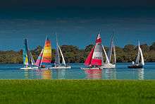 Boats on the Richmond River at Ballina
 Ballina beaches
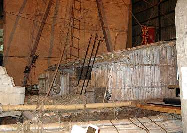 The Las Balsa raft at the Ballina Naval and Maritime Museum
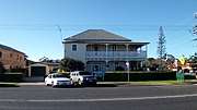 Riversleigh, Ballina
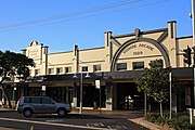 Wigmore Arcade
See also
References
- 1 2 3 4 5 6 7 Australian Bureau of Statistics (27 June 2017). "Ballina (Significant Urban Area)". 2016 Census QuickStats. Retrieved 30 November 2017.

- ↑ "Ballina Airport AWS". Climate Averages for Australian Sites. Bureau of Meteorology. Retrieved 24 November 2006.
- ↑ Macquarie Dictionary (4th ed.). Melbourne, Australia: The Macquarie Library Pty Ltd. 2005. ISBN 1-876429-14-3.
- ↑ Norman Tindale, Aboriginal Tribes of Australia: Their Terrain, Environmental Controls, Distribution, Limits, and Proper Names, Australian National University 1974 p.191.
- ↑ "The Richmond River Lighthouse". Lighthouses of New South Wales. Lighthouses of Australia Inc.
- ↑ Hagarty, D. The Booyong-Ballina Branch Line. Australian Railway Historical Society Bulletin, June 1953, pp. 65–68
- ↑ Kingsford-Smith, Charles; C. T. P. Ulm (1928). Story of "Southern Cross" Trans-Pacific Flight, 1928. Sydney: Penlington and Somerville.
- ↑ "Ballina Naval & Maritime Museum". Ballina Naval & Maritime Museum. Archived from the original on 4 October 2006. Retrieved 3 November 2006.
- ↑ "Las Balsa Expedition". Ballina Naval and Maritime Museum. Retrieved 28 December 2015.
- ↑ "Brundah, New South Wales State Heritage Register (NSW SHR) Number H00194". New South Wales State Heritage Register. Office of Environment and Heritage. Retrieved 18 May 2018.
- ↑ 2016 censusAustralian Bureau of Statistics (27 June 2017). "Ballina (Urban Centre)". 2016 Census QuickStats. Retrieved 20 February 2018.
- ↑ 2016 censusAustralian Bureau of Statistics (27 June 2017). "Ballina (Local Government Area)". 2016 Census QuickStats. Retrieved 20 February 2018.
- ↑ "Ballina". Destination NSW. Retrieved 11 Nov 2013.
- ↑ Stolz, Greg (25 September 2009). "Ballina's Big Prawn may move to Gold Coast". The Courier-Mail. Retrieved 23 December 2012.
- ↑ Turnbull, Samantha (7 November 2011). "Long live the Big Prawn". ABC News. Retrieved 23 December 2012.
- ↑ "Ballina Bunnings? $21.3 million. The Big Prawn? Priceless". The Northern Star. 7 October 2014. Retrieved 19 January 2017.
- ↑ "Google street view has blurred the face of Ballina's Big Prawn. Privacy first! • r/australia". reddit. Retrieved 2018-03-04.
- ↑ Latimer, Cole; Duke, Jennifer (2018-03-02). "Google facial recognition blurs out the Big Prawn". The Sydney Morning Herald. Retrieved 2018-03-04.
- ↑ "Climate Statistics for Ballina Airport, New South Wales". Retrieved August 7, 2015.
- ↑ Archived 24 September 2009 at the Wayback Machine.
- ↑ Ballina bypass – Road Projects. New South Wales Roads and Traffic Authority.
- ↑ Saxby-Junna, Kerry at the International Association of Athletics Federations
- ↑ "Sister City Agreement". Retrieved 10 July 2009.
External links
| Wikivoyage has a travel guide for Ballina (New South Wales). |
![]()