Angourie, New South Wales
| Angourie New South Wales | |
|---|---|
 Angourie pumping | |
|
Angourie Location in New South Wales | |
| Coordinates | 29°28′45″S 153°21′34″E / 29.47917°S 153.35944°ECoordinates: 29°28′45″S 153°21′34″E / 29.47917°S 153.35944°E |
| Population | 222 (2016 census)[1] |
| Postcode(s) | 2464 |
| LGA(s) | Clarence Valley |
| State electorate(s) | Clarence |
| Federal Division(s) | Page |
Angourie is a small coastal village in the Clarence Valley Council of New South Wales, Australia. Angourie is located 5 km south of Yamba, New South Wales, and is at the northern tip of Yuraygir National Park.[2] Towns that surround Angourie are Yamba and Wooloweyah.
In popular culture
Angourie was featured in the 1971 surfing film, Morning of the Earth. Most of the country scenes were photographed around Angourie and on the New South Wales North Coast mainly from Crescent Head, New South Wales to Cape Byron area.[3]
Attractions
.JPG)
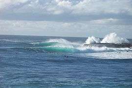
Angourie Beach was declared a National Surfing Reserve in 2007, the second site in Australia to be recognized for its significance to recreational surfing and is often visited by the world's best surfers.[4] Also of interest, Angourie Point is world renowned for the quality of its waves for surfing. Angourie beach is also known for Spookies which are short, very hollow right point breaks that occur just to the north.[4]
A local attraction of note are the Angourie Pools; a group of blue and green freshwater pools created when the old quarries hit underground springs. The story goes that the miners working on the quarries went home one night and came back the next morning to find the quarries filled with water. The pools are less than 20 meters from the ocean, and the two bodies of water are separated by mounds of quarried rock and earth. The pools are deep, approximately 15-20 metres, and are a very popular swimming spot.[2]
Yuraygir National Park, adjacent to Angourie, is considered to have one of the most spectacular coastal walks in the state.[2]
Demographics
In the 2011 Census, there were 184 people in Angourie. Aboriginal and Torres Strait Islander people made up 1.6% of the population.[5]
2011 Estimated Population Data by Gender/Age[5]
- 48.9% Male
- 51.1% Female
- 50.0 Est. Average Age
- 13.6% Population 0-14 Years
- 12.0 Population Over 65
2011 Registered Marital Status[5]
- Married 55.0%
- Separated 1.9%
- Divorced 10.6%
- Widowed 5%
- Never Married 27.5%
2011 Religious Affiliation[5]
- No Religion 25.9%
- Anglican 24.3%
- Catholic 22.2%
- Presbyterian and Reformed 3.2%
- Baptist 2.7%
2011 Languages Spoken at Home[5]
- English 91.3%
- Spanish 1.6%
- Hindi 1.6%
Gallery
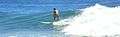 Surfer at Angourie
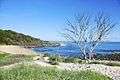 Angourie beach, Australia
 Surfers at Angourie Point on a cloudy day
 Angourie Beach, Australia
Notes
- ↑ Australian Bureau of Statistics (27 June 2017). "Angourie (State Suburb)". 2016 Census QuickStats. Retrieved 18 March 2018.

- 1 2 3 "Angourie - Clarence Tourism". Clarence Tourism. Retrieved 14 May 2017.
- ↑ "Morning of the Earth". Morning of the Earth - Places. Retrieved 15 May 2017.
- 1 2 "ANGOURIE BEACH - YAMBA". Visit NSW. Retrieved 14 May 2017.
- 1 2 3 4 5 "Census Data". 2011 Census QuickStats. Retrieved 15 May 2017.