Gowrie Little Plain, Queensland
| Gowrie Little Plain Queensland | |||||||||||||||
|---|---|---|---|---|---|---|---|---|---|---|---|---|---|---|---|
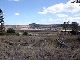 Farms along Yalangur Lilyvale Road, 2014 | |||||||||||||||
 Gowrie Little Plain | |||||||||||||||
| Coordinates | 27°25′S 151°50′E / 27.417°S 151.833°ECoordinates: 27°25′S 151°50′E / 27.417°S 151.833°E | ||||||||||||||
| Population | 65 (2016 census)[1] | ||||||||||||||
| Postcode(s) | 4352 | ||||||||||||||
| LGA(s) | Toowoomba Region | ||||||||||||||
| State electorate(s) | Condamine | ||||||||||||||
| Federal Division(s) | Groom | ||||||||||||||
| |||||||||||||||
Gowrie Little Plain is a locality in the Toowoomba Region local government area on the Darling Downs in southern Queensland, Australia. At the 2016 Australian Census, Gowrie Little Plain recorded a population of 65.[1] In the south of the locality are a series of hills which rise to around 600 m above sea level.
References
- 1 2 Australian Bureau of Statistics (27 June 2017). "Gowrie Little Plain (State Suburb)". 2016 Census QuickStats. Retrieved 25 March 2018.

This article is issued from
Wikipedia.
The text is licensed under Creative Commons - Attribution - Sharealike.
Additional terms may apply for the media files.