Felton, Queensland
| Felton Queensland | |||||||||||||||
|---|---|---|---|---|---|---|---|---|---|---|---|---|---|---|---|
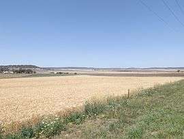 Farms along Southbrook Road, 2014 | |||||||||||||||
 Felton | |||||||||||||||
| Coordinates | 27°47′53″S 151°45′36″E / 27.79806°S 151.76000°ECoordinates: 27°47′53″S 151°45′36″E / 27.79806°S 151.76000°E | ||||||||||||||
| Population | 276 (2016 census)[1] | ||||||||||||||
| Postcode(s) | 4358 | ||||||||||||||
| LGA(s) | Toowoomba Region | ||||||||||||||
| State electorate(s) | Condamine | ||||||||||||||
| Federal Division(s) | |||||||||||||||
| |||||||||||||||
Felton is a locality in the Toowoomba Region of the Darling Downs in southern Queensland, Australia.[2] At the 2016 Australian Census Felton and surrounds recorded a population of 276.[1]
Hodgson Creek flows across the area and forms part of the southwest boundary. Mount Rolleston and Mount Perkins are both in Felton.
References
- 1 2 Australian Bureau of Statistics (27 June 2017). "Felton (State Suburb)". 2016 Census QuickStats. Retrieved 25 March 2018.

- ↑ "Felton - locality (entry 49261)". Queensland Place Names. Queensland Government. Retrieved 26 June 2017.
External links
![]()
This article is issued from
Wikipedia.
The text is licensed under Creative Commons - Attribution - Sharealike.
Additional terms may apply for the media files.