Brookstead, Queensland
| Brookstead Queensland | |||||||||||||||
|---|---|---|---|---|---|---|---|---|---|---|---|---|---|---|---|
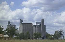
 Grain silos, Brookstead, 2009 | |||||||||||||||
 Brookstead | |||||||||||||||
| Coordinates | 27°45′29″S 151°26′48″E / 27.7580°S 151.4466°ECoordinates: 27°45′29″S 151°26′48″E / 27.7580°S 151.4466°E | ||||||||||||||
| Postcode(s) | 4364 | ||||||||||||||
| Area | 170.6 km2 (65.9 sq mi) | ||||||||||||||
| LGA(s) | Toowoomba Region | ||||||||||||||
| State electorate(s) | Condamine | ||||||||||||||
| Federal Division(s) | Groom | ||||||||||||||
| |||||||||||||||
Brookstead is a town and a locality in the Toowoomba Region, Queensland, Australia.[1][2]
Geography

The town is located in the south-west of the locality. The North Branch of the Condamine River forms the western boundary of the locality. The land is flat freehold farmland (approx 400 metres above sea level) and is used to grow crops, such as sorgum, corn and wheat.[3][4]
The Gore Highway traverses the locality from the south-east to the south-west slightly bypassing the town. At the bypass is the junction with the Brookstead Norworth Road which exits the locality through the north-west. The Millmerran railway line also traverses from the south-east to the south-west through the locality, passing through the town, which is serviced by the Brookstead railway station.[3][5]
History
The name Brookstead is derived from "brook" indicating creek/watercourse, and "stede" (Dutch) or "stadt" (German) indicating place, together meaning a creek-side camping place.[1]
Brookstead State School open on 25 January 1915.[6]
Education
Brookstead State School is a co-educational government primary school (P-6) at 30 Ware Street. In 2016, the school had enrolment of 32 children with 5 teachers (3 full-time equivalent) and 6 non-teaching staff (3 full-time equivalent).[7] The school opened on 25 January 1915.[8]
References
- 1 2 "Brookstead - town in Toowoomba Region (entry 4685)". Queensland Place Names. Queensland Government. Retrieved 1 August 2017.
- ↑ "Brookstead - locality in Toowoomba Region (entry 47898)". Queensland Place Names. Queensland Government. Retrieved 1 August 2017.
- 1 2 "Queensland Globe". State of Queensland. Retrieved 31 July 2017.
- ↑ "Sorghum comes through for Darling Downs croppers". Pacific Seeds. 13 September 2016. Archived from the original on 1 August 2017. Retrieved 1 August 2017.
- ↑ "Brookstead - railway station in Toowoomba Region (entry 4686)". Queensland Place Names. Queensland Government. Retrieved 1 August 2017.
- ↑ Queensland Family History Society (2010), Queensland schools past and present (Version 1.01 ed.), Queensland Family History Society, ISBN 978-1-921171-26-0
- ↑ "Annual Report 2016" (PDF). Brookstead State School. Archived (PDF) from the original on 31 July 2017. Retrieved 31 July 2017.
- ↑ "Queensland schools opening dates". Retrieved 1 February 2018.
Further reading
- Brookstead state school 100 years, Brookstead School Centenary Committee, 2015, retrieved 1 August 2017
External links
| Wikimedia Commons has media related to Brookstead, Queensland. |