Clermont, Queensland
| Clermont Queensland | |||||||||||||||
|---|---|---|---|---|---|---|---|---|---|---|---|---|---|---|---|
 Memorial marking the 1916 flood | |||||||||||||||
 Clermont | |||||||||||||||
| Coordinates | 22°49′0″S 147°38′0″E / 22.81667°S 147.63333°ECoordinates: 22°49′0″S 147°38′0″E / 22.81667°S 147.63333°E | ||||||||||||||
| Population | 3,031 (2016 census)[1] | ||||||||||||||
| Established | 1864 | ||||||||||||||
| Postcode(s) | 4721 | ||||||||||||||
| Elevation | 267.0 m (876 ft) | ||||||||||||||
| Location |
| ||||||||||||||
| LGA(s) | Isaac | ||||||||||||||
| State electorate(s) | Burdekin | ||||||||||||||
| Federal Division(s) | Capricornia | ||||||||||||||
| |||||||||||||||
| |||||||||||||||
Clermont is an agricultural town and locality in the Isaac Region, Queensland, Australia.[2][3] It is 274 kilometres (170 mi) south-west of Mackay on the junction of the Gregory and Peak Downs highways. At the 2011 census, Clermont had a population of 2,177.[4]
Today, Clermont is a major hub for the large coal mines in the region as well as serving agricultural holdings.
History


Ludwig Leichhardt was the first European to pass through the Clermont area in 1845, but it was the discovery of gold in 1861 that was responsible for the establishment of the town, close to what was Babbinburra clan land. The town reserve was proclaimed on 25 March 1864, although a gold field was declared in the area in 1862.[5] Clermont is named after Clermont-Ferrand in France; Clermont-Ferrand was the ancestral home of Oscar de Satge, one of the first European grazier who owned the Wolfang Downs pastoral run.[6]
Theresa Creek Post Office opened by 1863, was replaced by Coppermines Post Office at the end of 1863 and Clermont Post Office in 1864.[7]
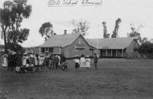
Clermont State School opened on 27 August 1867.[8][9][10]
Copper was discovered soon after. In the 1880s up to 4000 Chinese people were resident in Clermont, mining for gold and copper. This led to racial riots and the Chinese were removed from the region in 1888. The decorated soldier Billy Sing was born in Clermont in 1886 of a Chinese father and English mother.
The railway was extended north from Emerald to Clermont in February 1884. However, no passenger trains are available to or from Clermont.
The town was originally established on low-lying ground next to a lagoon or billabong, but flooding was always a problem, with four substantial floods occurring between 1864 and 1896. The greatest flood, in 1916, killed 65 people out of a town population of 1,500 and remains one of Australia's worst natural disasters in terms of life lost. Following the 1916 flood, many of the wooden buildings of the town were moved using steam traction engines to a new townsite on higher ground. A local amateur photographer, Gordon Pullar took numerous photographs of the moving buildings, published in the 1980s as "A Shifting Town".[11]
The Clermont public library was opened in 1962.[12]
On 27 January 1959 a secondary department was added Clermont State School providing secondary education (8-12). That arrangement ceased with the opening of Clermont State High School on 29 January 1990.[8][9][10][13]
Heritage listings
Clermont has a number of heritage-listed sites, including:
- Cemetery Road: Clermont Cemetery[14]
- 739 Fleurs Lane: Stone Farm Building[15]
- Oaky Creek, 20 kilometres (12 mi) West of Clermont on the Clermont-Alpha Road: Irlam's Ant Bed Building[16]
Coal Mining
Glencore is currently operating the Clermont Mine, located 12 kilometres (7.5 mi) north west of the township of Clermont in central Queensland.[17] When the mine reaches full capacity it will produce up to 12.2 million tonnes of thermal coal for international markets. Clermont Mine delivered its first conveyor of coal in April 2010.[18]
Clermont also hosted another larger coal mine; Blair Athol coal mine, located 20 kilometres (12 mi) north west of Clermont. The mine supplied customers in Asia and Europe with up to 12 million tonnes of thermal coal per annum. The coal deposit was originally discovered on the site in 1864[19] and was first mined in 1890. Between 1920 and 1945 coal was mined with an underground method, which is still visible today. The most recent open cut operation started in 1984. Blair Athol Mine was closed on 26 November 2012 after it completely mined out.[19] Its stockpile and train facilities will be used by the Clermont Mine, which began operations in 2010. The site is expected to take up to five years to rehabilitate.[19]
Facilities
The Isaac Regional Council operates a public library at the corner of Karmoo and Herschel Street.[20]
References
- ↑ Australian Bureau of Statistics (27 June 2017). "Clermont (State Suburb)". 2016 Census QuickStats. Retrieved 29 January 2018.

- ↑ "Clermont - town in Isaac Region (entry 7403)". Queensland Place Names. Queensland Government. Retrieved 28 September 2017.
- ↑ "Clermont - locality in Isaac Region (entry 49648)". Queensland Place Names. Queensland Government. Retrieved 28 September 2017.
- ↑ Australian Bureau of Statistics (31 October 2012). "Clermont (Urban Centre)". 2011 Census QuickStats. Retrieved 31 July 2013.
- ↑ "Clermont". Isaac Regional Council. Retrieved 11 April 2012.
- ↑ "Clermont". Did you know ... Isaac Regional Council. Retrieved 23 January 2014.
- ↑ Premier Postal History. "Post Office List". Premier Postal Auctions. Retrieved 10 May 2014.
- 1 2 "Opening and closing dates of Queensland Schools". Queensland Government. Retrieved 13 July 2014.
- 1 2 Queensland Family History Society (2010), Queensland schools past and present (Version 1.01 ed.), Queensland Family History Society, ISBN 978-1-921171-26-0
- 1 2 "Agency ID5099, Clermont State School". Queensland State Archives. Retrieved 14 July 2014.
- ↑ Stringer, Marguerite; Stringer, Richard (1 January 1986), A shifting town : glass plate images of Clermont and its people by G. C. Pullar, University of Queensland Press
- ↑ "Public Libraries Statistical Bulletin 2016-17" (PDF). Public Libraries Connect. State Library of Queensland. November 2017. p. 13. Retrieved 15 January 2018.
- ↑ "Agency ID8836, Clermont State High School". Queensland State Archives. Retrieved 14 July 2014.
- ↑ "Clermont Cemetery (entry 602756)". Queensland Heritage Register. Queensland Heritage Council. Retrieved 10 July 2013.
- ↑ "Stone Farm Building (entry 602555)". Queensland Heritage Register. Queensland Heritage Council. Retrieved 10 July 2013.
- ↑ "Irlam's Ant Bed Building (former) (entry 602010)". Queensland Heritage Register. Queensland Heritage Council. Retrieved 10 July 2013.
- ↑ Chambers, Matt (26 October 2013). "Glencore buys Rio's Clermont for $1bn". The Australian. Retrieved 1 June 2014.
- ↑ MacDonald, C 2010. Clermont mine delivers first conveyor of coal. The Australian Bulk Handling Review. Retrieved on 11 April 2012.
- 1 2 3 Melissa Maddison; Paul Robinson (26 November 2012). "Sun goes down on Blair Athol mine". ABC News. Australian Broadcasting Corporation. Retrieved 31 July 2013.
- ↑ "Clermont Library". Public Libraries Connect. State Library of Queensland. 21 June 2017. Retrieved 15 January 2018.
Further reading
External links
| Wikimedia Commons has media related to Clermont, Queensland. |