Banana, Queensland
| Banana Queensland | |||||||||||||||
|---|---|---|---|---|---|---|---|---|---|---|---|---|---|---|---|
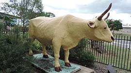 Statue of the bullock "Banana", 2014 | |||||||||||||||
 Banana | |||||||||||||||
| Coordinates | 24°28′20″S 150°07′41″E / 24.47222°S 150.12806°ECoordinates: 24°28′20″S 150°07′41″E / 24.47222°S 150.12806°E | ||||||||||||||
| Population | 356 (2016 census)[1] | ||||||||||||||
| Postcode(s) | 4702 | ||||||||||||||
| LGA(s) | Shire of Banana | ||||||||||||||
| State electorate(s) | Callide | ||||||||||||||
| Federal Division(s) | Flynn | ||||||||||||||
| |||||||||||||||
Banana is a small town and rural locality in the Shire of Banana, Central Queensland, Australia.[2][3] In the 2011 census, Banana had a population of 377 people.[4]
Geography
Banana is located at the intersection of the Dawson and Leichhardt highways, 46 kilometres (29 mi) west of the shire's administrative centre, Biloela.
History
The town was named in the early 1860s. The name derives from an old dun-coloured working bullock, called Banana, used by local stockmen to help them when herding some of the wilder cattle into the yards.[2][5][6]
At the time of the Canoona rush, gold was found in Banana's Gully (as it was then called) and a town of at least 2,000 people sprang up there.[5]
The post office at Banana was established on 1 September 1861.[7][8]
Banana Provisional School opened on 18 September 1871 and was upgraded to Banana State School on 16 February 1874. The school closed in 1935, but reopened on 25 January 1960.[9][10][11]
In 1880, the local government area Banana Division (later the Shire of Banana) was established with its headquarters in Banana (taking its name from the town). However, in 1930 the shire headquarters became Rannes and the shire offices were physically relocated from Banana to Rannes. Since 1946, the shire has its headquarters in Biloela.[12]
The mobile library service commenced in 2004.[13]
Economy
The beef industry is still a mainstay of the town and area, along with coal and agriculture.
Education
Banana State School is a government primary (P-7) school at 36 Bramston Street (24°28′09″S 150°07′52″E / 24.469134°S 150.131069°E). In 2012, there were 37 students enrolled with 3 teachers (2.5 full-time equivalent). There is no secondary school in Banana; the nearest are in Moura to the west and Biloela to the east.[14][15]
Amenities
Banana has a Uniting Church at 39 Bowen Street (Leichhardt Highway) at the corner with North Street (24°28′08″S 150°07′42″E / 24.46875°S 150.12821°E).[16]
Banana Shire Council operate a fortnightly mobile library service to Banana and the school.[17][18]
Past population
At the 2006 census, Banana had a population of 627.[19]
References
- ↑ Australian Bureau of Statistics (27 June 2017). "Banana (State Suburb)". 2016 Census QuickStats. Retrieved 23 January 2018.

- 1 2 "Banana - town in Shire of Banana (entry 1469)". Queensland Place Names. Queensland Government. Retrieved 24 September 2013.
- ↑ "Banana - locality in Shire of Banana (entry 49534)". Queensland Place Names. Queensland Government. Retrieved 24 September 2013.
- ↑ Australian Bureau of Statistics (31 October 2012). "Banana (SSC)". 2011 Census QuickStats. Retrieved 7 June 2014.
- 1 2 From series of articles published under the title Queensland place names and obelisks by Sydney May (formerly Honorary Secretary of the Queensland Place Names Committee) in Local Government, June 1957 - November 1964
- ↑ "Shire Information". Banana Shire. Banana Shire Council. Retrieved 23 September 2013.
- ↑ Porter, Harry S. (1954) Queensland Numeral Cancellations, p. 13. Melbourne: The Hawthorn Press
- ↑ Premier Postal History. "Post Office List". Premier Postal Auctions. Retrieved 10 May 2014.
- ↑ "Opening and closing dates of Queensland Schools". Queensland Government. Retrieved 7 June 2014.
- ↑ Queensland Family History Society (2010), Queensland schools past and present (Version 1.01 ed.), Queensland Family History Society, ISBN 978-1-921171-26-0
- ↑ "Agency ID4814, Banana State School". Queensland State Archives. Retrieved 8 June 2014.
- ↑ "Banana Shire". Queensland Places. Centre for the Government of Queensland, University of Queensland. Retrieved 7 June 2014.
- ↑ "Public Libraries Statistical Bulletin 2016-17" (PDF). Public Libraries Connect. State Library of Queensland. November 2017. p. 11. Retrieved 29 January 2018.
- ↑ "Queensland State and Non-State Schools". Queensland Government. Retrieved 7 June 2014.
- ↑ "2012 School Annual Report" (PDF). Banana State School. Retrieved 7 June 2014.
- ↑ "Banana Uniting Church". Dawson Valley Uniting Church. Retrieved 13 June 2014.
- ↑ "Library: Branches & Opening hours". Banana Shire Council. Retrieved 8 May 2017.
- ↑ "Banana Shire Mobile Library Timetable" (PDF). Banana Shire Council. Retrieved 8 May 2017.
- ↑ Australian Bureau of Statistics (25 October 2007). "Banana (Banana Shire) (State Suburb)". 2006 Census QuickStats. Retrieved 1 April 2011.
Further reading
- Perry, Betty; Banana Shire Council (2005), Two valleys - one destiny : a history of Banana, 'shire of opportunity', Banana Shire Council, ISBN 978-0-9750079-1-4
- Banana State School Centenary Committee; Jensen, Gwenda; Banana State School (1974), Banana, Central Queensland, yesterday and today : State School centenary 1874-1974, The Central Telegraph
External links
| Wikimedia Commons has media related to Banana, Queensland. |
- "Our Community". Banana State School. Archived from the original on 28 September 2007.