Ghizer District
| Ghizer District ضلع غذر | |
|---|---|
| District | |
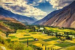
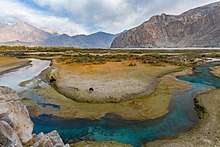
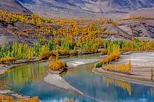
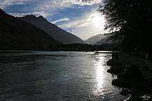
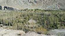
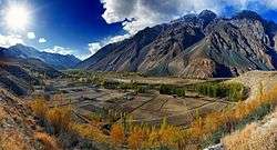 Ghizer is home to the dramatic landscapes of the Phander Valley | |
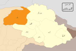 Map of Ghizer’s location | |
| Country |
|
| Province |
|
| Capital | Gahkuch |
| Time zone | UTC+5 (PST) |
| District Council | seats |
Ghizer District (Urdu: ضلع غذر) is the westernmost part of the Gilgit-Baltistan region of Pakistan. Its capital is Gahkuch. Ghizer is a crossroads between Gilgit and Chitral, and also to China and Tajikistan via the Karambar Pass through Ishkomen/Darkut Yasin (which are connected via Shandur Pass). Ghizer is a multi-ethnic district and three major languages are spoken: Shina, Khowar, and Burushaski. There are also Wakhi speakers in Ishkoman and some Tajiks.
The word Ghizer came form the name "Gherz" which means "refugees" in Khowar. "Gherz" is a village in Golaghmuli Valley, which is now known as Golaghmuli. Whenever the Chitral in the Suzerainty of the British Raj did forced some people to migrate towards Gupis. They were settled in the area between Chitral and Gupis and the area called Gherz and the people were called Gherzic. When Zulafiqar Ali Bhutto the President of Pakistan abolished the FCR system and had given another administrative district comprising the Tehsils (Political districts) the name Ghizer was given and agreed unanimously.[1]
Ghizer District comprises Punial, Gupis, Yaseen and Ishkoman Valleys. The major portion of its area was ruled over by Brooshay Rajas known as Raja Sha Burush, Khan Bahadur Issa Bahadur Akber Khan, Raja Anwar Khan, Raja Mirbaz Khan and last Broosh families Raja Jan Alam and Raja Muzafer (who was living in Golodass, also known as Anwerabad as its second name). Currently the living Raja families in the District have no administrative function but act as a leading role in the development of society. Their linkage goes back to Sha Burush. Sha Burush, Sha Katur, and Sha Khushwaqt are three brothers. The Punial is famous in regional history for the polo game. Historically these Rajas were the best polo players and had a polo team of giants. Historically two main characteristics of the folk dress of Ghizer is the khoi and the shokah. The khoi is headgear made of homespun woolen cloths, while the shokah is a homespun woolen cloak reaching to the ankle with long sleeves.
History
Historically the region has been ruled by ethnic Kho Rajas (Katoor, Brushay, Shins) indigenous to the region. They all lead tribes which were considered brothers but some Paloyo (Gupis Mehtar) had also governed for some period in Mehraja's period. The longest period of rule were the thoms of Yasin and Punial and later it was divided between the Mehtar of Chitral and the Maharaja of Kashmir. After 1895 all of Ghizer was annexed to Gilgit Agency, which was directly ruled by the British Government and not by the Kashmiri people.
The Rajas of Yasin Suleman Shah and Raja Gohar Aman stretched their rule to Gilgit Bagrot by pushing back Dogras and at some particular part of history remained undefeated rulers of the region stretching from Yasin to Gilgit. Later on, after the death of Gohar Aman due to the internal conspiracy, the Dogras of Maharaja Kashmir came to Yasin and the Mudoori debacle occurred in Yasin. The Mudoori were just not against the Mehtars but also the Muslims of the region.
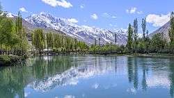
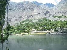
Tehsil Gupis is the central part of Ghizer district. There are many villages and lush green places, such as Shandur, Phunder Lake, Khalti Lake. The largest lake, Khalti, is very famous for its trout. There are also PTDC hotels available and also some private hotels in Ghahkuch.
Geography
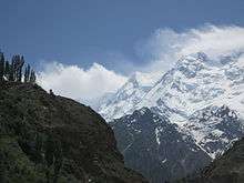
Ghizer district is the northernmost part of the Northern Areas and hence the extreme north of the country. It borders the Wakhan strip on its north-west, and China on its northern borders. On its west, there is Chitral District of Khyber Pakhtunkhwa; and on its east is situated Gilgit. Diamer District is on its south, which is again a part of the Northern areas. Gakuch is the capital of Ghizer District. Gupis has been serving as a junction between Yasin and Phander valley. It is the central place from all valleys like Phandar, Yasin, Poniyal, etc. The valley is located between the world's greatest mountain ranges, namely the Hindu Kush and Karakarum.
The highest peak Ghizer District is Koyo Zom (6,871 m) (Hindu Kush Range), which lies on the boundary between Ghizer District and Chitral.
Some of the main places in the district are Koh-i-Ghizer, Golaghmuli Valley, Ishkoman and Yasin valleys. Other places include Gupis, Chatorkhand, Imit and Utz.
Passes
Some of the passes in the district are:
- Shandur Pass (Punji-Lusht Plain between the boundary of Ghizer and Chitral District).
- Qurumbar Pass, Chillingi Pass.
- Hayal Pass and Naltar Pass (on the boundary of Ghizer and Gilgit Districts).
- Bichhar Pass (on the boundary of Ghizer and Gilgit Districts).
- Thoi Pass (on the boundary of Ghizer and Chitral Yarkhon).
- Darkot Pass (on the boundary of Ghizer and Chitral).
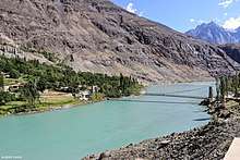
Rivers
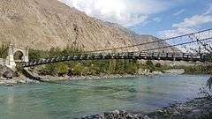
The main river in the district is the Ghizer River, which is formed from the Gupis and Ishkoman Rivers; both meet at Hatoon valley with Hayim as the point of confluence. The other tributaries include the Qurumbar River, Phakora River, Hayal River, Singul River and Yasin River, Phander river tributary which also join the main stream at different points.
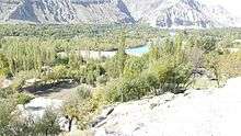
Lakes
- Handarap Lake
- Phander Lake
- Khalti Lake
- Karambar Lake
- Baha Lake (Langar Khukush)
- Shandur Lake
- Attar Lake
- Mathantar Lake
Tehsils
Colleges and schools
- Government High School Golaghmuli Phander
- Government high school Gullapur.
- Aga Khan Higher Secondary School Gahkuch, Ghizer
- Aga Khan Schools
- Aga Khan Higher Secondary School Sherqilla, Ghizer
- Hatun Degree College
- LRS Thingai Ghizer
- MIED College Phander
- World Roof Public School And College Hundur Yasin
- Inter College Gupis
- FG Boys High School Phander
- Govt Degree College Tause Yasin
- LRS Phander Ghizer
- Ghizer Public School Gahkuch
- Diamond Jubilee High School Gupis, Ghizer
- Lalik Jan Shaheed (NH)Army Public School and College Hundur Yasin
- Diamond Jubilee Learning Resource High School Sandi Yasin
- Begal Academy Thoi Yasin
- Diamond Jubilee High School Thoi Yasin
Education
According to the Alif Ailaan Pakistan District Education Rankings 2015, Ghizer is ranked 52 out of 148 districts in terms of education. For facilities and infrastructure, the district is ranked 71 out of 148.[2]
See also
| Wikimedia Commons has media related to Ghizar District. |
- Districts of Gilgit-Baltistan
- Shandur Polo Festival
- Phander Valley
- Khalti Lake
- Shandur Pass
- Gupis Valley
- Puniyal Valley
- Ishkomen Valley
- Yasin Valley
- Baha Lake
- Handarap Lake
- Khukush Nala
- Langer
References
- ↑ https://www.myghizer.com Archived 2015-11-19 at the Wayback Machine.
- ↑ "Individual district profile link, 2015". Alif Ailaan. Retrieved 2015-05-07.
| Passes | 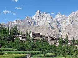 | |
|---|---|---|
| Valleys | ||
| Cities and towns | ||
| Rivers, glaciers and lakes | ||
| Architecture | ||
| See also | ||