Gördes
| Gördes | |
|---|---|
| District | |
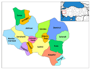 Location of Gördes within Turkey. | |
 Gördes Location of Gördes | |
| Coordinates: 38°56′N 28°17′E / 38.933°N 28.283°E | |
| Country |
|
| Region | Aegean |
| Province | Manisa |
| Area[1] | |
| • District | 947.44 km2 (365.81 sq mi) |
| Elevation | 578 m (1,896 ft) |
| Population (2012)[2] | |
| • Urban | 10,588 |
| • District | 30,491 |
| • District density | 32/km2 (83/sq mi) |
| Time zone | UTC+2 (EET) |
| • Summer (DST) | UTC+3 (EEST) |
| Postal code | 45xxx |
| Area code(s) | 236 |
| Licence plate | 45 |
| Climate | Csa |
| Website | www.gordes.bel.tr |
Gördes is a town and district of Manisa Province in the Aegean region of Turkey. According to the 2000 census, population of the district is 38,110 of which 10,809 live in the town of Gördes.[3][4] The district covers an area of 947 km2 (366 sq mi),[5] and the town lies at an elevation of 578 m (1,896 ft).
History
Gördes has been held by the Persians, Macedonians, Roman and Byzantine empires, and in 1071AD passed to the Turks.
Economy
Gördes is one of the handmade Turkish carpet production centers in Manisa. Gördes carpets have different pattern and styles. See: Ghiordes knot.
Gordes district is linked to the neighboring districts. The main source income is tobacco and poppy production and wheat, barley is grown. In recent years production of cherries, strawberries has begun production Other crops include potatoes, peas, tomatoes and cucumbers and wine.
The area also has olive trees.
The area has mining with Coal and Zeolite being the main deposits but kaolin, nickel-iron, titanium, zeolite beds are also available. In addition, feldspar, marble, kyanite, chalcedony, chrome, quartz, boron is among mined in the region.
See also
Notes
- ↑ "Area of regions (including lakes), km²". Regional Statistics Database. Turkish Statistical Institute. 2002. Retrieved 2013-03-05.
- ↑ "Population of province/district centers and towns/villages by districts - 2012". Address Based Population Registration System (ABPRS) Database. Turkish Statistical Institute. Retrieved 2013-02-27.
- ↑ Turkish Statistical Institute. "Census 2000, Key statistics for urban areas of Turkey" (XLS) (in Turkish). Retrieved 2009-04-15.
- ↑ GeoHive. "Statistical information on Turkey's administrative units". Archived from the original on 2008-09-25. Retrieved 2009-04-15.
- ↑ Statoids. "Statistical information on districts of Turkey". Retrieved 2009-04-13.
References
- Falling Rain Genomics, Inc. "Geographical information on Gördes, Turkey". Retrieved 2009-04-14.
External links
- District municipality's official website (in Turkish)
- Road map of Gördes and environs
- Various images of Gördes, Manisa
Coordinates: 38°55′58″N 28°17′25″E / 38.93278°N 28.29028°E