Fouchères, Aube
| Fouchères | ||
|---|---|---|
| Commune | ||
| ||
 Fouchères Location within Grand Est region  Fouchères | ||
| Coordinates: 48°08′59″N 4°15′56″E / 48.1497°N 4.2656°ECoordinates: 48°08′59″N 4°15′56″E / 48.1497°N 4.2656°E | ||
| Country | France | |
| Region | Grand Est | |
| Department | Aube | |
| Arrondissement | Troyes | |
| Canton | Bar-sur-Seine | |
| Government | ||
| • Mayor (2008–2014) | Jean-Pierre Thorey | |
| Area1 | 8.58 km2 (3.31 sq mi) | |
| Population (2008)2 | 494 | |
| • Density | 58/km2 (150/sq mi) | |
| Time zone | UTC+1 (CET) | |
| • Summer (DST) | UTC+2 (CEST) | |
| INSEE/Postal code | 10158 /10260 | |
| Elevation |
130–192 m (427–630 ft) (avg. 138 m or 453 ft) | |
|
1 French Land Register data, which excludes lakes, ponds, glaciers > 1 km2 (0.386 sq mi or 247 acres) and river estuaries. 2 Population without double counting: residents of multiple communes (e.g., students and military personnel) only counted once. | ||

Fouchères is a commune in the Aube department in north-central France located at the river Seine.
Population
| Historical population | ||
|---|---|---|
| Year | Pop. | ±% |
| 1962 | 320 | — |
| 1968 | 339 | +5.9% |
| 1975 | 321 | −5.3% |
| 1982 | 394 | +22.7% |
| 1990 | 422 | +7.1% |
| 1999 | 450 | +6.6% |
| 2008 | 494 | +9.8% |
See also
References
 The Seine River and the bridge of Fouchères
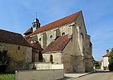 Nativity of the Blessed Virgin Mary Church
 The wash house (lavoir)
 War memorial
| Wikimedia Commons has media related to Fouchères, Aube. |
This article is issued from
Wikipedia.
The text is licensed under Creative Commons - Attribution - Sharealike.
Additional terms may apply for the media files.