Faggeto Lario
| Faggeto Lario | |
|---|---|
| Comune | |
| Comune di Faggeto Lario | |
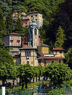 Central Faggeto Lario from a ferry up the lake | |
 Faggeto Lario Location of Faggeto Lario in Italy | |
| Coordinates: 45°51′N 9°10′E / 45.850°N 9.167°ECoordinates: 45°51′N 9°10′E / 45.850°N 9.167°E | |
| Country | Italy |
| Region | Lombardy |
| Province | Province of Como (CO) |
| Area | |
| • Total | 18.1 km2 (7.0 sq mi) |
| Population (Dec. 2004) | |
| • Total | 1,227 |
| • Density | 68/km2 (180/sq mi) |
| Time zone | UTC+1 (CET) |
| • Summer (DST) | UTC+2 (CEST) |
| Postal code | 22020 |
| Dialing code | 031 |
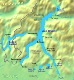
Faggeto Lario (Comasco: Fasgée [faˈʒeː]) is a comune (municipality) in the Province of Como in the Italian region of Lombardy, located about 45 kilometres (28 mi) north of Milan and about 7 kilometres (4 mi) northeast of Como. As of 31 December 2004, it had a population of 1,227 and an area of 18.1 km².[1]
Faggeto Lario borders the following municipalities: Albavilla, Albese con Cassano, Caglio, Carate Urio, Caslino d'Erba, Erba, Laglio, Nesso, Pognana Lario, Tavernerio, Torno.
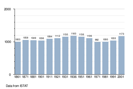
Demographic evolution
References
| Settlements |
|  |
|---|---|---|
| Islands | ||
| Rivers | ||
| Valleys | ||
| Mountains | ||
| Landmarks | ||
| Films | ||
| People | ||

This article is issued from
Wikipedia.
The text is licensed under Creative Commons - Attribution - Sharealike.
Additional terms may apply for the media files.