Tavernerio
| Tavernerio Tavarnee (Lombard) | |
|---|---|
| Comune | |
| Comune di Tavernerio | |
 Tavernerio Location of Tavernerio in Italy | |
| Coordinates: 45°48′N 9°9′E / 45.800°N 9.150°ECoordinates: 45°48′N 9°9′E / 45.800°N 9.150°E | |
| Country | Italy |
| Region | Lombardy |
| Province | Province of Como (CO) |
| Frazioni | Solzago, Ponzate, Rovascio, Urago |
| Area | |
| • Total | 12.0 km2 (4.6 sq mi) |
| Elevation | 460 m (1,510 ft) |
| Population (Dec. 2004) | |
| • Total | 5,534 |
| • Density | 460/km2 (1,200/sq mi) |
| Demonym(s) | Taverneriesi |
| Time zone | UTC+1 (CET) |
| • Summer (DST) | UTC+2 (CEST) |
| Postal code | 22038 |
| Dialing code | 031 |
Tavernerio (Comasco: Tavarnee [taʋarˈneː]) is a comune (municipality) in the Province of Como in the Italian region Lombardy, located about 35 kilometres (22 mi) north of Milan and about 6 kilometres (4 mi) east of Como. As of 31 December 2004, it had a population of 5,534 and an area of 12.0 square kilometres (4.6 sq mi).[1]
The municipality of Tavernerio contains the frazioni (subdivisions, mainly villages and hamlets) Solzago, Ponzate, Rovascio, and Urago.
Tavernerio borders the following municipalities: Albese con Cassano, Como, Faggeto Lario, Lipomo, Montorfano, Torno.
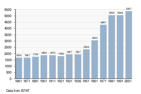
Demographic evolution
References

This article is issued from
Wikipedia.
The text is licensed under Creative Commons - Attribution - Sharealike.
Additional terms may apply for the media files.