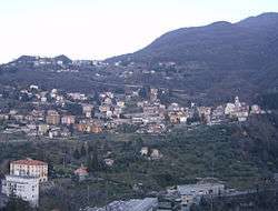
Perledo
| Perledo Perled (Lombard) | |
|---|---|
| Comune | |
| Comune di Perledo | |
 Perledo | |
 Perledo Location of Perledo in Italy | |
| Coordinates: 46°1′N 9°18′E / 46.017°N 9.300°ECoordinates: 46°1′N 9°18′E / 46.017°N 9.300°E | |
| Country | Italy |
| Region | Lombardy |
| Province | Province of Lecco (LC) |
| Area | |
| • Total | 12.53 km2 (4.84 sq mi) |
| Elevation | 199-1,350 m (−4,230 ft) |
| Population (Dec. 2010) | |
| • Total | 945 |
| • Density | 75/km2 (200/sq mi) |
| Demonym(s) | perledesi |
| Time zone | UTC+1 (CET) |
| • Summer (DST) | UTC+2 (CEST) |
| Postal code | 23828 |
| Dialing code | 0341 |
| Patron saint | Saint Martin |
| Saint day | September 11 |
| Website | Official website |
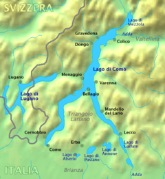
Perledo (Comasco, Lecchese: Perled [perˈleːt]) is a comune (municipality) in the Province of Lecco in the Italian region Lombardy, located about 60 kilometres (37 mi) north of Milan and about 20 kilometres (12 mi) northwest of Lecco. As of 31 December 2004, it had a population of 900 and an area of 12.5 square kilometres (4.8 sq mi).[1]
Perledo borders the following municipalities: Bellano, Esino Lario, Menaggio, Parlasco, San Siro, Varenna.
Perledo includes the following "frazione" or hamlets: Tondello, Olivedo, Vezio, Regolo, Bologna, Gisazio, Regoledo, Cestaglia, Gittana, Riva di Gittana, Portone, Panighetto.[2]
References
- ↑ All demographics and other statistics: Italian statistical institute Istat.
- ↑ "Comune di Perledo" (in Italian). Comuni-Italiani.it. Retrieved 13 March 2015.
External links
- Official website

| Settlements |
|  |
|---|---|---|
| Islands | ||
| Rivers | ||
| Valleys | ||
| Mountains | ||
| Landmarks | ||
| Films | ||
| People | ||

This article is issued from
Wikipedia.
The text is licensed under Creative Commons - Attribution - Sharealike.
Additional terms may apply for the media files.