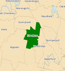
Electoral district of Stretton
| Stretton Queensland—Legislative Assembly | |||||||||||||||
|---|---|---|---|---|---|---|---|---|---|---|---|---|---|---|---|
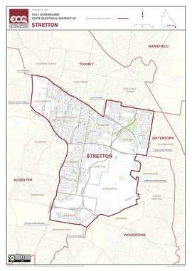 Electoral map of Stretton 2017 | |||||||||||||||
| State | Queensland | ||||||||||||||
| MP | Duncan Pegg | ||||||||||||||
| Party | Labor | ||||||||||||||
| Namesake | Stretton | ||||||||||||||
| Electors | 32,976 (2017) | ||||||||||||||
| Area | 37 km2 (14.3 sq mi) | ||||||||||||||
| Coordinates | 27°37′S 153°4′E / 27.617°S 153.067°ECoordinates: 27°37′S 153°4′E / 27.617°S 153.067°E | ||||||||||||||
| |||||||||||||||
Electoral map of Stretton 2008
Stretton is an electoral district of the Legislative Assembly in the Australian state of Queensland.
The district is based in the southern suburbs of Brisbane. It is named for the suburb of Stretton and also includes the suburbs of Calamvale, Eight Mile Plains, Kuraby, Sunnybank Hills and Underwood. It was first contested at the 2001 state election.
Members for Stretton
| Member | Party | Term | |
|---|---|---|---|
| Stephen Robertson | Labor | 2001–2012 | |
| Freya Ostapovitch | Liberal National | 2012–2015 | |
| Duncan Pegg | Labor | 2015–present | |
Election results
| Party | Candidate | Votes | % | ± | |
|---|---|---|---|---|---|
| Labor | Duncan Pegg | 14,061 | 50.6 | +8.1 | |
| Liberal National | Freya Ostapovitch | 7,884 | 28.4 | −9.9 | |
| One Nation | Shane Holley | 3,298 | 11.9 | +11.9 | |
| Greens | Anisa Nandaula | 2,059 | 7.4 | +1.0 | |
| Independent | Shyamal Reddy | 484 | 1.7 | +1.7 | |
| Total formal votes | 27,786 | 95.0 | −2.9 | ||
| Informal votes | 1,454 | 5.0 | +2.9 | ||
| Turnout | 29,240 | 87.2 | −0.7 | ||
| Two-party-preferred result | |||||
| Labor | Duncan Pegg | 16,640 | 59.9 | +4.6 | |
| Liberal National | Freya Ostapovitch | 11,146 | 40.1 | −4.6 | |
| Labor hold | Swing | +4.6 | |||
References
External links
- Electorate Profile (Antony Green, ABC)
This article is issued from
Wikipedia.
The text is licensed under Creative Commons - Attribution - Sharealike.
Additional terms may apply for the media files.