Electoral district of Murrumba
| Murrumba Queensland—Legislative Assembly | |||||||||||||||
|---|---|---|---|---|---|---|---|---|---|---|---|---|---|---|---|
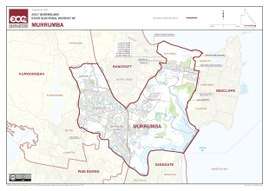 Electoral map of Murrumba 2017 | |||||||||||||||
| State | Queensland | ||||||||||||||
| MP | Steven Miles | ||||||||||||||
| Party | Labor | ||||||||||||||
| Namesake | An Aboriginal word for good | ||||||||||||||
| Electors | 35,997 (2017) | ||||||||||||||
| Area | 61 km2 (23.6 sq mi) | ||||||||||||||
| Coordinates | 27°12′S 153°2′E / 27.200°S 153.033°ECoordinates: 27°12′S 153°2′E / 27.200°S 153.033°E | ||||||||||||||
| |||||||||||||||

Electoral map of Murrumba 2008
Murrumba is an electoral district of the Legislative Assembly in the Australian state of Queensland.
The district is based in the outer northern suburbs of Brisbane. It includes the suburbs of Deception Bay, Kippa-Ring, Murrumba Downs and Rothwell. The electorate was first contested in 1912.
Members for Murrumba
| Member | Party | Term | |
|---|---|---|---|
| James Forsyth | Liberal | 1912–1918 | |
| Richard Warren | Country | 1918–1932 | |
| Frank Nicklin | Country | 1932–1950 | |
| David Nicholson | Country | 1950–1972 | |
| Des Frawley | Country | 1972–1974 | |
| National | 1974–1977 | ||
| Joe Kruger | Labor | 1977–1986 | |
| Dean Wells | Labor | 1986–2012 | |
| Reg Gulley | Liberal National | 2012–2015 | |
| Chris Whiting | Labor | 2015–2017 | |
| Steven Miles | Labor | 2017–present | |
Election results
| Party | Candidate | Votes | % | ± | |
|---|---|---|---|---|---|
| Labor | Steven Miles | 14,111 | 45.7 | −3.3 | |
| Liberal National | Reg Gulley | 7,953 | 25.7 | −14.8 | |
| One Nation | Scott Dare | 6,002 | 19.4 | +19.4 | |
| Greens | Jason Kennedy | 2,841 | 9.2 | +0.5 | |
| Total formal votes | 30,907 | 95.6 | −2.0 | ||
| Informal votes | 1,437 | 4.4 | +2.0 | ||
| Turnout | 32,344 | 87.3 | +2.4 | ||
| Two-party-preferred result | |||||
| Labor | Steven Miles | 18,396 | 59.5 | +3.2 | |
| Liberal National | Reg Gulley | 12,511 | 40.5 | −3.2 | |
| Labor hold | Swing | +3.2 | |||
References
External links
- Electorate Profile (Antony Green, ABC)
This article is issued from
Wikipedia.
The text is licensed under Creative Commons - Attribution - Sharealike.
Additional terms may apply for the media files.