Electoral district of Southport
| Southport Queensland—Legislative Assembly | |||||||||||||||
|---|---|---|---|---|---|---|---|---|---|---|---|---|---|---|---|
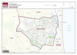 Electoral map of Southport 2017 | |||||||||||||||
| State | Queensland | ||||||||||||||
| MP | Rob Molhoek | ||||||||||||||
| Party | Liberal National | ||||||||||||||
| Namesake | Southport | ||||||||||||||
| Electors | 33,150 (2017) | ||||||||||||||
| Area | 31 km2 (12.0 sq mi) | ||||||||||||||
| Coordinates | 27°57′S 153°23′E / 27.950°S 153.383°ECoordinates: 27°57′S 153°23′E / 27.950°S 153.383°E | ||||||||||||||
| |||||||||||||||
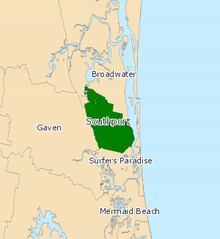
Electoral map of Southport 2008
Southport is an electoral district of the Legislative Assembly in the Australian state of Queensland.
The district is based in the northern part of the Gold Coast. It is named for the suburb of Southport, and also includes the suburbs of Arundel, Labrador, Molendinar and Parkwood. It was first created for the 1977 election.
An earlier district based in the same region was also called Southport. It existed from 1950 to 1960.
Members for Southport
| First incarnation (1950–1960) | |||
|---|---|---|---|
| Member | Party | Term | |
| Eric Gaven | Country | 1950–1960 | |
| Second incarnation (1977–present) | |||
| Member | Party | Term | |
| Peter White | Liberal | 1977–1980 | |
| Doug Jennings | National | 1980–1987 | |
| Mick Veivers | National | 1987–2001 | |
| Peter Lawlor | Labor | 2001–2012 | |
| Rob Molhoek | Liberal National | 2012–present | |
Election results
| Party | Candidate | Votes | % | ± | |
|---|---|---|---|---|---|
| Liberal National | Rob Molhoek | 12,499 | 47.1 | −2.5 | |
| Labor | Judy Searle | 7,877 | 29.7 | −1.9 | |
| Greens | Michelle Le Plastrier | 2,806 | 10.6 | +2.4 | |
| Independent | Rick Flori | 2,597 | 9.8 | +9.8 | |
| Consumer Rights | Johan Joubert | 769 | 2.9 | +2.9 | |
| Total formal votes | 26,548 | 94.8 | −2.6 | ||
| Informal votes | 1,458 | 5.2 | +2.6 | ||
| Turnout | 28,006 | 82.4 | +1.1 | ||
| Two-party-preferred result | |||||
| Liberal National | Rob Molhoek | 15,197 | 57.2 | −0.6 | |
| Labor | Judy Searle | 11,351 | 42.8 | +0.6 | |
| Liberal National hold | Swing | −0.6 | |||
References
External links
- Electorate Profile (Antony Green, ABC)
This article is issued from
Wikipedia.
The text is licensed under Creative Commons - Attribution - Sharealike.
Additional terms may apply for the media files.