Electoral district of Redlands
| Redlands Queensland—Legislative Assembly | |||||||||||||||
|---|---|---|---|---|---|---|---|---|---|---|---|---|---|---|---|
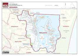 Electoral map of Redlands 2017 | |||||||||||||||
| State | Queensland | ||||||||||||||
| Dates current | 1972–present | ||||||||||||||
| MP | Kim Richards | ||||||||||||||
| Party | Labor Party | ||||||||||||||
| Namesake | Redland Bay | ||||||||||||||
| Electors | 33,996 (2017) | ||||||||||||||
| Area | 213 km2 (82.2 sq mi) | ||||||||||||||
| Coordinates | 27°38′S 153°18′E / 27.633°S 153.300°ECoordinates: 27°38′S 153°18′E / 27.633°S 153.300°E | ||||||||||||||
| |||||||||||||||
Electoral map of Redlands 2008
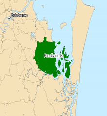
Redlands is an electoral district of the Legislative Assembly in the Australian state of Queensland. It primarily covers coastal suburbs on the southside of the city of Brisbane, from Thornlands south to the Logan River.
Members for Redlands
| Member | Party | Term | |
|---|---|---|---|
| Ted Baldwin | Labor | 1972–1974 | |
| John Goleby | Country | 1974–1974 | |
| National | 1974–1985 | ||
| Paul Clauson | National | 1985–1989 | |
| Darryl Briskey | Labor | 1989–1992 | |
| John Budd | Labor | 1992–1995 | |
| John Hegarty | National | 1995–2001 | |
| John English | Labor | 2001–2009 | |
| Peter Dowling | Liberal National | 2009–2015 | |
| Matt McEachan | Liberal National | 2015–2017 | |
| Kim Richards | Labor | 2017–present | |
Election results
| Party | Candidate | Votes | % | ± | |
|---|---|---|---|---|---|
| Labor | Kim Richards | 9,591 | 32.3 | −3.3 | |
| Liberal National | Matt McEachan | 9,435 | 31.8 | −11.5 | |
| One Nation | Jason Quick | 5,262 | 17.7 | +17.7 | |
| Independent | Peter Dowling | 2,889 | 9.7 | +9.7 | |
| Greens | David Keogh | 2,527 | 8.5 | +0.8 | |
| Total formal votes | 29,704 | 96.0 | −1.7 | ||
| Informal votes | 1,243 | 4.0 | +1.7 | ||
| Turnout | 30,947 | 89.4 | +3.0 | ||
| Two-party-preferred result | |||||
| Labor | Kim Richards | 15,760 | 53.1 | +4.3 | |
| Liberal National | Matt McEachan | 13,944 | 46.9 | −4.3 | |
| Labor gain from Liberal National | Swing | +4.3 | |||
References
External links
- Electorate Profile (Antony Green, ABC)
This article is issued from
Wikipedia.
The text is licensed under Creative Commons - Attribution - Sharealike.
Additional terms may apply for the media files.