Electoral district of Keppel
| Keppel Queensland—Legislative Assembly | |||||||||||||||
|---|---|---|---|---|---|---|---|---|---|---|---|---|---|---|---|
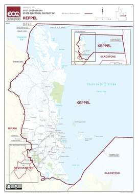 Electoral map of Keppel 2017 | |||||||||||||||
| State | Queensland | ||||||||||||||
| MP | Brittany Lauga | ||||||||||||||
| Party | Labor | ||||||||||||||
| Namesake | Great Keppel Island | ||||||||||||||
| Electors | 34,691 (2017) | ||||||||||||||
| Area | 22,165 km2 (8,558.0 sq mi) | ||||||||||||||
| Coordinates | 22°55′S 150°43′E / 22.917°S 150.717°ECoordinates: 22°55′S 150°43′E / 22.917°S 150.717°E | ||||||||||||||
| |||||||||||||||

Electoral map of Keppel 2008
Keppel is an electoral district in the state of Queensland, Australia.
The electoral district encompasses the central Queensland coast from the mouth of the Fitzroy River in the south to Shoalwater Bay to the north. Major communities located within this electorate include Yeppoon, Emu Park, Byfield, and the Rockhampton suburbs of Parkhurst and Lakes Creek.
Members for Keppel
| First incarnation (1912–1960) | ||||
|---|---|---|---|---|
| Member | Party | Term | ||
| James Larcombe | Labor | 1912–1929 | ||
| Owen Daniel | CPNP | 1929–1936 | ||
| David Daniel | Country | 1936–1944 | ||
| Walter Ingram | Labor | 1944–1952 | ||
| Viv Cooper | Labor | 1952–1957 | ||
| Queensland Labor | 1957 | |||
| Merv Thackeray | Labor | 1957–1960 | ||
| Second incarnation (1992–present) | ||||
| Member | Party | Term | ||
| Vince Lester | National | 1992–2004 | ||
| Paul Hoolihan | Labor | 2004–2012 | ||
| Bruce Young | Liberal National | 2012–2015 | ||
| Brittany Lauga | Labor | 2015–present | ||
Election results
| Party | Candidate | Votes | % | ± | |
|---|---|---|---|---|---|
| Labor | Brittany Lauga | 13,304 | 43.1 | −0.8 | |
| One Nation | Matt Loth | 7,865 | 25.5 | +25.5 | |
| Liberal National | Peter Blundell | 7,691 | 24.9 | −15.0 | |
| Greens | Clancy Mullbrick | 2,039 | 6.6 | +1.8 | |
| Total formal votes | 30,899 | 96.6 | −1.7 | ||
| Informal votes | 1,098 | 3.4 | +1.7 | ||
| Turnout | 31,997 | 90.6 | +2.5 | ||
| Two-candidate-preferred result | |||||
| Labor | Brittany Lauga | 16,419 | 53.1 | −1.0 | |
| One Nation | Matt Loth | 14,480 | 46.9 | +46.9 | |
| Labor hold | Swing | −1.0 | |||
References
External links
- Electorate Profile (Antony Green, ABC)
This article is issued from
Wikipedia.
The text is licensed under Creative Commons - Attribution - Sharealike.
Additional terms may apply for the media files.