Les Échelles
| Les Échelles | ||
|---|---|---|
| Commune | ||
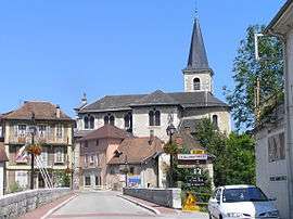 The church in Les Échelles | ||
| ||
 Les Échelles Location within Auvergne-Rhône-Alpes region  Les Échelles | ||
| Coordinates: 45°26′15″N 5°45′17″E / 45.4375°N 5.7547°ECoordinates: 45°26′15″N 5°45′17″E / 45.4375°N 5.7547°E | ||
| Country | France | |
| Region | Auvergne-Rhône-Alpes | |
| Department | Savoie | |
| Arrondissement | Chambéry | |
| Canton | Le Pont-de-Beauvoisin | |
| Intercommunality | CC Cœur de Chartreuse | |
| Government | ||
| • Mayor (2014–2020) | Cédric Vial | |
| Area1 | 3.75 km2 (1.45 sq mi) | |
| Population (2014)2 | 1,217 | |
| • Density | 320/km2 (840/sq mi) | |
| Time zone | UTC+1 (CET) | |
| • Summer (DST) | UTC+2 (CEST) | |
| INSEE/Postal code | 73105 /73360 | |
| Elevation | 364–459 m (1,194–1,506 ft) | |
|
1 French Land Register data, which excludes lakes, ponds, glaciers > 1 km2 (0.386 sq mi or 247 acres) and river estuaries. 2 Population without double counting: residents of multiple communes (e.g., students and military personnel) only counted once. | ||
.svg.png)
Les Échelles is a commune in the Savoie department in the Auvergne-Rhône-Alpes region in south-eastern France.
See also
References
| Wikimedia Commons has media related to Les Échelles. |
This article is issued from
Wikipedia.
The text is licensed under Creative Commons - Attribution - Sharealike.
Additional terms may apply for the media files.