East South Central states

The East South Central states constitute one of the nine Census Bureau Divisions of the United States.

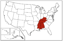
A map of the United States Census Bureau Region 3, Division 6, "East South Central", consisting of the states of Alabama, Kentucky, Mississippi, and Tennessee.

Four states make up the division: Alabama, Kentucky, Mississippi, and Tennessee. The division is one of three that together make up the larger Census Bureau Region known as the South (the other two of which are the South Atlantic states and the West South Central states).

The East South Central States form the core of Old Dixie, one of the nine moral regions identified by James Patterson and Peter Kim in their acclaimed 1991 geopolitical best-seller, The Day America Told The Truth.

Demographics

As of 2010, the East South Central states had a combined population of 18,022,810. The East South Central region covers 183,401 square miles of land.

States in the East South Central Region
State2010 CensusLand Area
Alabama4,833,72252,419
Kentucky4,395,29540,409
Mississippi2,984,92648,430
Tennessee6,495,97842,143
Top Ten Largest Cities by Population in the East South Central Region
City2010 Pop.
1Memphis, Tennessee653,450
2Nashville, Tennessee634,464
3Louisville, Kentucky609,893
4Lexington, Kentucky308,428
5Birmingham, Alabama212,113
6Montgomery, Alabama201,332
7Mobile, Alabama194,899
8Huntsville, Alabama186,254
9Knoxville, Tennessee183,270
10Jackson, Mississippi173,744

Politics in the East South Central states

Parties
NonpartisanDemocratic-RepublicanDemocraticNational RepublicanWhigConstitutional UnionRepublicanDixiecratAmerican Independent
  • Bold denotes election winner.
Presidential electoral votes in the East South Central States since 1792
YearAlabamaKentuckyMississippiTennessee
1792No electionWashingtonNo electionNo election
1796No electionJeffersonNo electionJefferson
1800No electionJeffersonNo electionJefferson
1804No electionJeffersonNo electionJefferson
1808No electionMadisonNo electionMadison
1812No electionMadisonNo electionMadison
1816No electionMonroeNo electionMonroe
1820MonroeMonroeMonroeMonroe
1824JacksonClayJacksonJackson
1828JacksonJacksonJacksonJackson
1832JacksonClayJacksonJackson
1836Van BurenHarrisonVan BurenWhite
1840Van BurenHarrisonHarrisonHarrison
1844PolkClayPolkClay
1848CassTaylorCassTaylor
1852PierceScottPierceScott
1856BuchananBuchananBuchananBuchanan
1860BreckinridgeBellBreckinridgeBell
1864No electionMcClellanNo electionLincoln
1868GrantSeymourNo electionGrant
1872GrantHendricksGrantHendricks
1876TildenTildenTildenTilden
1880HancockHancockHancockHancock
1884ClevelandClevelandClevelandCleveland
1888ClevelandClevelandClevelandCleveland
1892ClevelandClevelandClevelandCleveland
1896BryanMcKinleyBryanBryan
1900BryanBryanBryanBryan
1904ParkerParkerParkerParker
1908BryanBryanBryanBryan
1912WilsonWilsonWilsonWilson
1916WilsonWilsonWilsonWilson
1920CoxCoxCoxHarding
1924DavisCoolidgeDavisDavis
1928SmithHooverSmithHoover
1932RooseveltRooseveltRooseveltRoosevelt
1936RooseveltRooseveltRooseveltRoosevelt
1940RooseveltRooseveltRooseveltRoosevelt
1944RooseveltRooseveltRooseveltRoosevelt
1948ThurmondTrumanThurmondTruman
1952StevensonStevensonStevensonEisenhower
1956StevensonEisenhowerStevensonEisenhower
1960ByrdNixonByrdNixon
1964GoldwaterJohnsonGoldwaterJohnson
1968WallaceNixonWallaceNixon
1972NixonNixonNixonNixon
1976CarterCarterCarterCarter
1980ReaganReaganReaganReagan
1984ReaganReaganReaganReagan
1988BushBushBushBush
1992BushClintonBushClinton
1996DoleClintonDoleClinton
2000BushBushBushBush
2004BushBushBushBush
2008McCainMcCainMcCainMcCain
2012RomneyRomneyRomneyRomney
2016TrumpTrumpTrumpTrump
YearAlabamaKentuckyMississippiTennessee

Coordinates: 36°00′N 88°00′W / 36.0°N 88.0°W / 36.0; -88.0

This article is issued from Wikipedia. The text is licensed under Creative Commons - Attribution - Sharealike. Additional terms may apply for the media files.