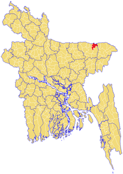
Dowarabazar Upazila
| Dowarabazar দোয়ারাবাজার ꠖꠥꠀꠞꠣꠛꠣꠎꠣꠞ | |
|---|---|
| Nickname(s): Duarabazar | |
 | |
| Division | Sylhet Division |
| District | Sunamganj District |
| Established | 1976 |
| Government | |
| • MP (Sunamgonj-5) | MR. Muhibur Rahman Manik (Awami League) |
| Area | |
| • Total | 324.19 km2 (125.17 sq mi) |
| Population | |
| • Total | 157,240 |
| • Density | 490/km2 (1,300/sq mi) |
| Time zone | UTC+6 (BST) |
| Postal code | 3070 |
| Website |
www |
Dowarabazar (Bengali: দোয়ারাবাজার, Sylheti: ꠖꠥꠀꠞꠣꠛꠣꠎꠣꠞ) is an Upazila of Sunamganj District in the Division of Sylhet, Bangladesh.[1]
Geography
Dowarabazar is located at 25°03′00″N 91°34′00″E / 25.0500°N 91.5667°E . It has 27112 households and total area 324.19 km² and bounded by the Indian state of Meghalaya and border on the north, and Chhatak Upazila on the south and east, Sunamganj Sadar Upazila on the west. Main rivers are Surma, Jadukata etc.
Demographics
As of the 2011 Bangladesh census, Dowarabazar has a population of 157240. Males constitute 50.74% of the population, and females 49.26%. This Upazila's eighteen up population is 76530.
Administration
Dowarabazar has 9 Unions/Wards, 166 Mauzas/Mahallas, and 294 villages. Dowarabazar Model Govt Primary School, Dowarabazar High School and Dowarabazar Degree College is situated in Dowarabazar town.
Notable residents
- Dewan Mohammad Azraf, teacher, author, politician, journalist and philosopher
- Kafil Uddin, Baul musician
- Kakon Bibi, Bangladeshi freedom fighter, Bir Protik
- Abdul Majid, Bangladeshi freedom fighter, Bir Protik
- Abdul halim, Bangladeshi freedom fighter, Bir Protik
See also
References
- ↑ Jayanta Singh Roy (2012), "Dowarabazar Upazila", in Sirajul Islam and Ahmed A. Jamal, Banglapedia: National Encyclopedia of Bangladesh (Second ed.), Asiatic Society of Bangladesh
| Upazila/Thana: | ||
|---|---|---|
Capital: Sylhet | ||
| Habiganj District | 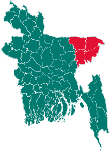 | |
| Moulvibazar District | ||
| Sunamganj District | ||
| Sylhet District | ||