List of districts of Manipur
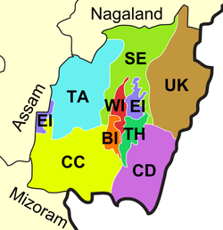
Map of districts of Manipur
Manipur, a state of India, has sixteen administrative districts.
Administration
A district of an Indian state is an administrative geographical unit, headed by a district magistrate or a deputy commissioner, an officer belonging to the Indian Administrative Service. The district magistrate or the deputy commissioner is assisted by a number of officials belonging to different wings of the administrative services of the state.
A superintendent of Police, an officer belonging to Indian Police Service is entrusted with the responsibility of maintaining law and order and related issues.
On 9 December 2016, the government created 7 new districts, bringing the total number of districts to 16.[1]
Divisions and Districts
- Inner Manipur Division: (Imphal) - Districts of Bishnupur, Imphal West, Imphal East, Thoubal, and Kakching
- North Manipur Division: (Ukhrul) - Districts of Tamenglong, Kangpokpi, Senapati, Ukhrul, and Kamjong
- South Manipur Division: (Churachandpur) - Districts of Jiribam, Noney, Pherzawl, Churachandpur, Chandel, and Tengnoupal
Districts
The sixteen districts of Manipur state are:
| Code | District | Headquarters | Population (2011)[2] | Area (km²) | Density (/km²) | Official website |
| BI | Bishnupur | Bishnupur | 240,363 | 496 | 415 | http://bishnupur.nic.in/ |
| TH | Thoubal | Thoubal | 420,517 | 514 | 713 | http://thoubal.nic.in/ |
| EI | Imphal East | Porompat | 452,661 | 710 | 555 | http://imphaleast.nic.in/ |
| WI | Imphal West | Lamphelpat | 514,683 | 519 | 847 | http://imphalwest.nic.in/ |
| SE | Senapati | Senapati | 354,772 | 3,269 | 116 | http://Senapati.nic.in/ |
| UK | Ukhrul | Ukhrul | 183,115 | 4,547 | 31 | http://ukhrul.nic.in/ |
| CD | Chandel | Chandel | 144,028 | 3,317 | 37 | http://chandel.nic.in/ |
| CC | Churachandpur | Churachandpur | 271.274 | 4,574 | 50 | http://churachandpur.nic.in/%5Bpermanent+dead+link%5D |
| TA | Tamenglong | Tamenglong | 140,143 | 4,391 | 25 | http://tamenglong.nic.in/ |
| Not yet assigned | Jiribam | Jiribam | Survey pending | Pending | Pending | Yet to be created. Bifurcated from Imphal East |
| KPI | Kangpokpi (Sadar Hills) | Kangpokpi | Survey pending | Pending | Pending | Yet to be created. Bifurcated from Senapati |
| KAK | Kakching | Kakching | Survey pending | Pending | Pending | https://web.archive.org/web/20170202030501/http://www.kakching.nic.in/ |
| Not yet assigned | Tengnoupal | Tengnoupal | Survey pending | Pending | Pending | Yet to be created. Bifurcated from Chandel |
| Not yet assigned | Kamjong | Kamjong | Survey pending | Pending | Pending | Yet to be created. Bifurcated from Ukhrul |
| Not yet assigned | Noney | Noney(Longmai) | Survey pending | Pending | Pending | Yet to be created. Bifurcated from Tamenglong |
| PZ | Pherzawl | Pherzawl | Survey pending | Pending | Pending | Yet to be created. Bifurcated from Churachandpur |
References
- ↑ http://indianexpress.com/article/explained/manipur-violence-new-districts-okram-ibobi-united-naga-council-4436039/
- ↑ "Ranking of Districts by Population Size, 2001 and 2011" (XLS). The Registrar General & Census Commissioner, India, New Delhi-110011. 2010–2011. Retrieved 2011-09-18.
| States | ||
|---|---|---|
| Union Territories | ||
| Related topics | ||
This article is issued from
Wikipedia.
The text is licensed under Creative Commons - Attribution - Sharealike.
Additional terms may apply for the media files.