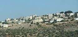
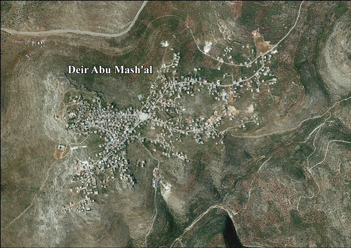
Deir Abu Mash'al
| Deir Abu Mash'al | |
|---|---|
| Other transcription(s) | |
| • Arabic | دير ابو مشعل |
 Deir Abu Mash'al | |
 Deir Abu Mash'al Location of Deir Abu Mash'al within Palestine | |
| Coordinates: 31°59′54″N 35°04′06″E / 31.99833°N 35.06833°ECoordinates: 31°59′54″N 35°04′06″E / 31.99833°N 35.06833°E | |
| Palestine grid | 156/156 |
| Governorate | Ramallah & al-Bireh |
| Government | |
| • Type | Municipality |
| • Head of Municipality | Ibrahim Mohammad Yousi Zhran[1] |
| Population (2007) | |
| • Jurisdiction | 3,522 |
| Name meaning | The monastery with the cresset (a beacon)[2] |
Deir Abu Mash'al (Arabic: دير ابو مشعل) is a Palestinian village in the Ramallah and al-Bireh Governorate, located 24 kilometers (15 mi) west of Ramallah in the northern West Bank. According to the Palestinian Central Bureau of Statistics (PCBS), the village had a population of approximately 3,522 inhabitants in 2007.[3]
Location
Deir Abu Mash'al is located 16.4 kilometers (10.2 mi) northwest of Ramallah. It is bordered by Al Itihad to the south and east, Abud to the east and north, and Shuqba to the west.[4]
History
Sherds from the Byzantine, Byzantine/Umayyad and Crusader/Ayyubid eras have been found here.[5]
There are a wall at the highest part of the village, with cisterns below it, which are assumed to be the remains of the 12th century Crusader castle named Bellifortis. It possibly belonged to the Hospitalliers in 1167.[6]
The Palestine Exploration Fund's Survey of Western Palestine (SWP) visited the place (in 1873), and noted: "There are here indications of an important fort, apparently of Crusading times. A rock platform, roughly square, about 50 yards wide, occupies the top of the hill, and many well-cut stones, with rustic boss and a draft 3 inches wide, lie round. On the west is a wall of rubble faced with small ashlar, which stands over a rock scarp. On the north are traces of a similar wall. There is a small tank, well cemented, with a groined roof. There is also a large well near. A rock-cut drain some 6 inches wide leads towards the well. On the south are rock-cut steps. On the east, quarries and two tanks, rock-cut, but roofed in with masonry. One measured 20 feet by 12 feet."[7] Modern opinion is that the remains are from a major Byzantine monastery, which had a Crusader tower added to it.[8]
Sherds from the Mamluk era have also been found here.[5]
Ottoman era
In 1517, the village was included in the Ottoman empire with the rest of Palestine and in the 1596 tax-records it was in the Nahiya of Jabal Quds of the Liwa of Al-Quds. The population was 42 households, all Muslim. They paid a tax rate of 33,3% on agricultural products, which included wheat, barley, olive trees, fruit trees, goats and beehives, in addition to "occasional revenues"; a total of 3,300 akçe.[9] Sherds from the early Ottoman era have also been found here.[5]
In 1838 Edward Robinson noted Deir Abu Mesh'al on his travels in the region,[10][11] as a Muslim village, located in the Beni Zeid district, north of Jerusalem.[12]
In 1870, Victor Guérin found the village to have 450 inhabitants. He further noted: "At the highest point I notice, on a large platform, the traces of a powerful construction, some of which are still inferior, and which was built with beautiful cut stones of a magnificent device. Under this platform reigns a huge cistern dug into the rock. To the south stands a gigantic wall of very thick wall, but built with stones of a much lesser apparatus than those which constitute the lower courses of which I have just spoken. The houses in the village are roughly built, but almost all of them contain ancient materials. Near these Moslem dwellings lay on the leveled rock several areas, perhaps dating back to the earliest antiquity, and which the present fellahs still use to beat their barley or wheat."[13] An Ottoman village list of about the same year, 1870, indicated 33 houses and a population of 159, though the population count included men, only.[14][15]
In 1882, the Palestine Exploration Fund's Survey of Western Palestine (SWP) described Deir Abu Meshal as "A small and partly ruinous stone village in a very strong position on a lofty hill. [] A pool exists on the south side of the village, which supplies the place with water."[16]
In 1896 the population of Der abu masch'al was estimated to be about 273 persons.[17]
British Mandate era
In the 1922 census of Palestine, conducted by the British Mandate authorities, the village, named Dair Abu Masha'al, had a population of 289, all Muslim,[18] increasing in the 1931 census to 404 Muslim, in 88 inhabited houses.[19]
In the 1945 Statistics the population of Deir Abu Mash'al was 510 Muslims,[20] with 8,778 dunams (8.8 km2; 3.4 sq mi) of land according to an official land and population survey.[21] Of this, 2,076 dunams were plantations and irrigable land, 1,058 used for cereals,[22] while 19 dunams (1.9 ha; 4.7 acres) were built-up (urban) land.[23]
Jordanian era
In the wake of the 1948 Arab–Israeli War, and after the 1949 Armistice Agreements, Deir Abu Mash'al came under Jordanian rule.
The Jordanian census of 1961 found 987 inhabitants at Deir Abu Mash'al.[24]
1967-present
After the Six-Day War in 1967, Deir Abu Mash'al has been under Israeli occupation.
After the 1995 accords, 85% of village land is defined as Area B land, while the remaining 15% is defined as Area C. Israel has confiscated hundreds of dunams of land for bypass roads.[25]
References
- ↑ West Bank Archived 2007-06-30 at the Wayback Machine. Local Elections ( Round two)- Successful candidates by local authority, gender and No. of votes obtained, Deir Abu Mish'al p. 22
- ↑ Palmer, 1881, p. 228
- ↑ 2007 PCBS Census Archived December 10, 2010, at the Wayback Machine.. Palestinian Central Bureau of Statistics. p.113.
- ↑ Deir Abu Mash'al Village Profile, ARIJ, p. 4
- 1 2 3 Finkelstein, et al, 1997, p. 201
- ↑ Röhricht, 1893, RHH, p. 113, No. 433; cited in Pringle, 1997, p. 46
- ↑ Conder and Kitchener, 1882, SWP II, p. 210
- ↑ Ellenblum, 2003, pp. 128-130
- ↑ Hütteroth and Abdulfattah, 1977, p. 114
- ↑ Robinson and Smith, vol. 2, p. 133
- ↑ Robinson and Smith, vol. 3, pp. 30, 58, 66
- ↑ Robinson and Smith, 1841, vol 3, Appendix 2, p. 124
- ↑ Guérin, 1875, pp. 118-119
- ↑ Socin, 1879, p. 151 It was also noted to be in the Beni Zeid district
- ↑ Hartmann, 1883, p. 106 also found 33 houses
- ↑ Conder and Kitchener, 1882, SWP II, p. 290
- ↑ Schick, 1896, p. 124
- ↑ Barron, 1923, Table VII, Sub-district of Ramallah, p. 16
- ↑ Mills, 1932, p. 48
- ↑ Government of Palestine, Department of Statistics, 1945, p. 26
- ↑ Government of Palestine, Department of Statistics. Village Statistics, April, 1945. Quoted in Hadawi, 1970, p. 64
- ↑ Government of Palestine, Department of Statistics. Village Statistics, April, 1945. Quoted in Hadawi, 1970, p. 111
- ↑ Government of Palestine, Department of Statistics. Village Statistics, April, 1945. Quoted in Hadawi, 1970, p. 161
- ↑ Government of Jordan, 1964, p. 24
- ↑ Deir Abu Mash'al Village Profile, ARIJ, p. 15
Bibliography
- Barron, J.B., ed. (1923). Palestine: Report and General Abstracts of the Census of 1922. Government of Palestine.
- Clermont-Ganneau, C.S. (1898). "La carte de la Palestine d'apres la mosaique de Madeba". Recueil d'archéologie orientale. 2: 166–176.
- Conder, C.R.; Kitchener, H.H. (1882). The Survey of Western Palestine: Memoirs of the Topography, Orography, Hydrography, and Archaeology. 2. London: Committee of the Palestine Exploration Fund.
- Ellenblum, Ronnie (2003). Frankish Rural Settlement in the Latin Kingdom of Jerusalem. Cambridge University Press. ISBN 0521521874.
- Finkelstein, I.; Lederman, Zvi, eds. (1997). Highlands of many cultures. Tel Aviv: Institute of Archaeology of Tel Aviv University Publications Section. ISBN 965-440-007-3.
- Government of Jordan, Department of Statistics (1964). First Census of Population and Housing. Volume I: Final Tables; General Characteristics of the Population (PDF).
- Government of Palestine, Department of Statistics (1945). Village Statistics, April, 1945.
- Guérin, V. (1875). Description Géographique Historique et Archéologique de la Palestine (in French). 2: Samarie, pt. 2. Paris: L'Imprimerie Nationale.
- Hadawi, S. (1970). Village Statistics of 1945: A Classification of Land and Area ownership in Palestine. Palestine Liberation Organization Research Center.
- Hartmann, M. (1883). "Die Ortschaftenliste des Liwa Jerusalem in dem türkischen Staatskalender für Syrien auf das Jahr 1288 der Flucht (1871)". Zeitschrift des Deutschen Palästina-Vereins. 6: 102–149.
- Hütteroth, Wolf-Dieter; Abdulfattah, Kamal (1977). Historical Geography of Palestine, Transjordan and Southern Syria in the Late 16th Century. Erlanger Geographische Arbeiten, Sonderband 5. Erlangen, Germany: Vorstand der Fränkischen Geographischen Gesellschaft. ISBN 3-920405-41-2.
- Mills, E., ed. (1932). Census of Palestine 1931. Population of Villages, Towns and Administrative Areas. Jerusalem: Government of Palestine.
- Palmer, E.H. (1881). The Survey of Western Palestine: Arabic and English Name Lists Collected During the Survey by Lieutenants Conder and Kitchener, R. E. Transliterated and Explained by E.H. Palmer. Committee of the Palestine Exploration Fund.
- Pringle, Denys (1997). Secular buildings in the Crusader Kingdom of Jerusalem: an archaeological Gazetteer. Cambridge University Press. ISBN 0521 46010 7.
- Robinson, E.; Smith, E. (1841). Biblical Researches in Palestine, Mount Sinai and Arabia Petraea: A Journal of Travels in the year 1838. 2. Boston: Crocker & Brewster.
- Robinson, E.; Smith, E. (1841). Biblical Researches in Palestine, Mount Sinai and Arabia Petraea: A Journal of Travels in the year 1838. 3. Boston: Crocker & Brewster.
- Röhricht, R. (1893). (RRH) Regesta regni Hierosolymitani (MXCVII-MCCXCI) (in Latin). Berlin: Libraria Academica Wageriana.
- Schick, C. (1896). "Zur Einwohnerzahl des Bezirks Jerusalem". Zeitschrift des Deutschen Palästina-Vereins. 19: 120–127.
- Socin, A. (1879). "Alphabetisches Verzeichniss von Ortschaften des Paschalik Jerusalem". Zeitschrift des Deutschen Palästina-Vereins. 2: 135–163.
External links
- Welcome To Dayr Abu Mash'al
- Survey of Western Palestine, Map 14: IAA, Wikimedia commons
- Deir Abu Mash'al Village (Fact Sheet), Applied Research Institute–Jerusalem (ARIJ)
- Deir Abu Mash'al Village Profile, ARIJ
- Deir Abu Mash'al aerial photo, ARIJ
- Locality Development Priorities and Needs in Deir Abu Mash'al Village, ARIJ
