Davis station (California)
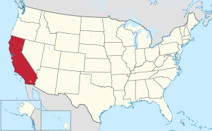
Davis, CA | |||||||||||||||||||||
|---|---|---|---|---|---|---|---|---|---|---|---|---|---|---|---|---|---|---|---|---|---|
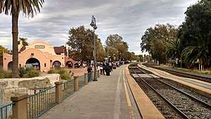 Passengers wait at Davis station in November 2017 | |||||||||||||||||||||
| Location |
840 Second Street Davis, California | ||||||||||||||||||||
| Coordinates | 38°32′37″N 121°44′12″W / 38.54361°N 121.73667°WCoordinates: 38°32′37″N 121°44′12″W / 38.54361°N 121.73667°W | ||||||||||||||||||||
| Owned by | City of Davis | ||||||||||||||||||||
| Line(s) |
UP Martinez Subdivision CFNR West Valley Line[1] | ||||||||||||||||||||
| Platforms | 1 side platform, 1 island platform | ||||||||||||||||||||
| Tracks | 2 | ||||||||||||||||||||
| Construction | |||||||||||||||||||||
| Parking | Yes | ||||||||||||||||||||
| Bicycle facilities | Yes | ||||||||||||||||||||
| Disabled access | Yes | ||||||||||||||||||||
| Other information | |||||||||||||||||||||
| Station code | DAV | ||||||||||||||||||||
| History | |||||||||||||||||||||
| Opened | 1868 | ||||||||||||||||||||
| Rebuilt | 1914, 1986 | ||||||||||||||||||||
| Traffic | |||||||||||||||||||||
| Passengers (2015) | 372,554[2] | ||||||||||||||||||||
| Services | |||||||||||||||||||||
| |||||||||||||||||||||
|
Southern Pacific Railroad Station | |||||||||||||||||||||
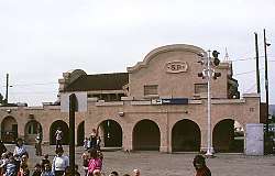 Davis station in February 1984 | |||||||||||||||||||||
  | |||||||||||||||||||||
| Area | 0.2 acres (0.08 ha) | ||||||||||||||||||||
| Built | 1914 | ||||||||||||||||||||
| Built by | Southern Pacific Railroad | ||||||||||||||||||||
| Architectural style | Mission/Spanish Revival | ||||||||||||||||||||
| NRHP reference # | 76000541[3] | ||||||||||||||||||||
| Added to NRHP | November 7, 1976 | ||||||||||||||||||||
Davis, formerly known as Davisville, is a train station in Davis, California. The station is owned by the City, while the tracks are owned by the Union Pacific Railroad. The station is served by Amtrak California Zephyr, Capitol Corridor, and Coast Starlight trains.
History
.jpg)
It was built by the California Pacific Railroad between August 24 and November 15, 1868, connecting Davis to Washington (now part of West Sacramento) to the east, Vallejo to the southwest, and Marysville to the northeast via a wye at Davis to Woodland, where the line separated to go northwest to Redding via Tehama and northeast to Marysville via a drawbridge at Knights Landing. In 1871 the Cal-P (as it later was called) was taken over by the Central Pacific Railroad; a fire later burned down the 19th century-style station. In 1914 the Central Pacific built a second depot, which was remodeled in 1986. The depot was listed in the National Register of Historic Places in 1976.[4]
References
- ↑ SMA Rail Consulting (April 2016). "California Passenger Rail NETWORK SCHEMATICS" (PDF). California Department of Transportation. p. 3.
- ↑ "Amtrak Fact Sheet, FY2015, State of California" (PDF). Amtrak. November 2015. Retrieved 21 January 2016.
- ↑ National Park Service (2010-07-09). "National Register Information System". National Register of Historic Places. National Park Service.
- ↑ Yolo County Listings on the National Register of Historic Places (Building #76000541)
External links

- Amtrak – Stations – Davis, CA
- Davis Amtrak Station (USA RailGuide -- TrainWeb)
- Davis (DAV)--Great American Stations (Amtrak)
| .svg.png) | |
† - Shared between Yolo and Sacramento Counties. | ||