Darling Mills Creek
| Darling Mills | |
| Creek[1] | |
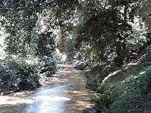
 Weir at the Darling Mills site, Windsor Road | |
| Country | Australia |
|---|---|
| State | New South Wales |
| Regions | Sydney basin (IBRA), Greater Western Sydney |
| Local government areas | The Hills, Parramatta |
| Part of | Parramatta River catchment |
| Tributaries | |
| - left | Bellbird Creek, Bidjigal Creek, Blue Gum Creek, Hunts Creek |
| - right | Excelsior Creek, Sawmill Creek, Bellamy Farm Creek |
| Source | Thompsons Corner |
| - location | West Pennant Hills |
| Mouth | confluence with Toongabbie Creek to form the Parramatta River |
| - location | North Parramatta |
| Length | 10 km (6 mi) |
| Basin | 107 km2 (41 sq mi) |
| Nature reserves | Bidjigal; Munro; Eric Mobbs Recreation |
| State forests | Cumberland; Darling Mills |
The Darling Mills Creek, an urban watercourse[1] that is part of the Parramatta River catchment, is located in Greater Western Sydney, New South Wales, Australia.
Course and features
The Darling Mills Creek rises in the north-western suburbs of Sydney, west of Thompsons Corner, near the intersection of Castle Hill Road and Pennant Hills Road, within the suburb of West Pennant Hills. The headwaters lie on the watershed between the Hornsby Plateau and the Cumberland Plain. The creek flows generally west, then south, joined by its tributaries including the Bidjigal, Sawmill, Excelsior, Blue Gum, Bellbird, Bellamy Farm creeks and the dammed Hunts Creek downstream of Lake Parramatta, before reaching its confluence with the Toongabbie Creek to form the Parramatta River, in the suburb of North Parramatta, in land adjoining the northern boundary of the Cumberland Hospital.[2] The course of the creek is approximately 10 kilometres (6.2 mi); and the creek passes through the Cumberland State Forest, the Darling Mills State Forest, Bidjigal Reserve, Excelsior Park, and many smaller reserves and parks.[1]
The Darling Mills Creek is transversed by the Cumberland Highway, the M2 Hills Motorway,[3] and marks the boundary between Windsor Road and Church Street in North Parramatta.
History
The land adjacent to the Parramatta River and its tributaries, including the Darling Mills Creek, was occupied for many thousands of years by the Burramattagal, Toongagal, Wallumattagal, Wangal, and Wategora Aboriginal peoples. They used the river as an important source of food and a place for trade.[4][5]
The Darling Mills Creek takes its name from a watermill constructed a short distance from the confluence with Toongabbie Creek.
An earlier watermill was built by Samuel Marsden near the confluence. It milled flour from 1804 to 1818.
In 1825, the Darling Flour Mills were built for John Raine, upstream on the Windsor Road.
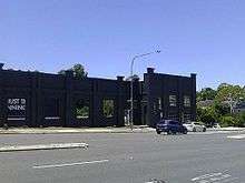
The Darling Mills site was taken over by Sydney Woollen Mills, which operated from 1870 to 1975. Sydney Woollen Mills originally used steam rather than water power. Part of the facade of the building remains on the site, which is now occupied by Bunnings Warehouse's North Parramatta store. There is a weir on the creek nearby that was constructed in the nineteenth century.[6]
See also
References
- 1 2 3 "Darling Mills". Geographical Names Register (GNR) of NSW. Geographical Names Board of New South Wales. Retrieved 28 December 2013.
- ↑ "Darling Mills Creek Sub-Catchment". Education Resource Kit. Upper Parramatta River Catchment Trust. 2002. Archived from the original on 29 October 2013. Retrieved 28 December 2013.
- ↑ "Darling Mills Creek Bridge walking track re-opened" (PDF) (Press release). Transurban and Government of New South Wales. 23 May 2012. Retrieved 28 December 2013.
- ↑ "Parramatta River Walk" (PDF). Walking Volunteers. September 2011. Retrieved 4 September 2012.
- ↑ "A brief history of our waterways". Parramatta City Council. 12 December 2010. Retrieved 4 September 2012.
- ↑ http://www.environment.nsw.gov.au/heritageapp/ViewHeritageItemDetails.aspx?ID=5051959
External links
- Upper Parramatta River Catchment Trust webpage
- Darling Mills Creek Sub-Catchment Map (PDF) (Map). Upper Parramatta Catchment Trust. December 2011. Archived from the original (PDF) on 4 March 2014.
- "Bidjigal (D1010489) Reserve: Plan of Management" (PDF). Department of Primary Industries, Catchments and Lands. Government of New South Wales and Bidjigal Reserve Trust. 10 April 2012. Archived from the original (PDF) on 28 December 2013.
- Dam across the Darling Mills Creek at North Rocks (streaming video). YouTube. 2 August 2013.
- Scott Bird Photography
Coordinates: 33°44′56″S 151°02′49″E / 33.74889°S 151.04694°E