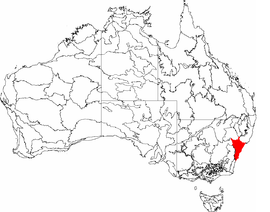
Sydney Basin
| Sydney Basin New South Wales | |||||||||||||||
|---|---|---|---|---|---|---|---|---|---|---|---|---|---|---|---|
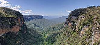 Jamison Valley in the Blue Mountains. | |||||||||||||||
 | |||||||||||||||
| Coordinates | 33°56′53″S 150°45′36″E / 33.94806°S 150.76000°ECoordinates: 33°56′53″S 150°45′36″E / 33.94806°S 150.76000°E | ||||||||||||||
| Population | 5,000,000[1] | ||||||||||||||
| • Density | 78/km2 (202/sq mi) | ||||||||||||||
| Area | 64,000 km2 (24,710.5 sq mi)[2] | ||||||||||||||
| |||||||||||||||
| |||||||||||||||
The Sydney Basin is an interim Australian bioregion and is both a structural entity and a depositional area, now preserved on the east coast of New South Wales, Australia and with some of its eastern side now subsided beneath the Tasman Sea. The basin is named for the city of Sydney, on which it is centred.
Around 5,000 metres (16,000 ft) thick, the Sydney Basin consists of Permian and Triassic sedimentary rocks, which stretches from Newcastle in the north to Batemans Bay in the south, and west to the Great Dividing Range. The basin is also home to the major centres of Newcastle and Wollongong, and contains economically significant reserves of coal.
Sydney’s famous harbour and the sculptured cliffs of the Blue Mountains are signature formations of relatively hard upper strata of sandstone. The basin contains the UNESCO World Heritage-listed Greater Blue Mountains Area.[3]
Geography
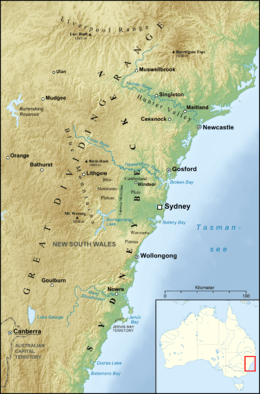
According to NSW Primary Industries, the basin extends through approximately 350 kilometres (220 mi) of coastline from Newcastle in the north to Durras Lake (near Batemans Bay) in the south. From Durras Lake the western boundary continues in a line through Lithgow to around Ulan (near Mudgee). To the north the boundary extends 120 kilometres (75 mi) along the Liverpool Range to a point 80 kilometres (50 mi) north of Muswellbrook, and then runs 200 kilometres (120 mi) back to the coast at Newcastle. To the east the basin continues to the edge of the continental shelf.[4] The total area of the basin is approximately 44,000 square kilometres (17,000 sq mi) onshore plus 5,000 square kilometres (1,900 sq mi) offshore.[5] The centre of the basin is located around 30 kilometres (19 mi) west of the Sydney central business district at Fairfield, though only the youngest Triassic (middle Triassic) rocks are exposed in the Sydney area.[6]
The Australian Government Department of the Environment and Energy classifies the basin as an interim Australian bioregion consisting of 3,629,597 hectares (8,968,930 acres).[7] Meanwhile, Geoscience Australia classifies that the basin covers 64,000 square kilometres (25,000 sq mi), of which 36,000 square kilometres (14,000 sq mi) is onshore and 28,000 square kilometres (11,000 sq mi) is offshore with under water depths of up to 4,500 metres (14,800 ft).[2] Another Australian Government agency classifies that the basin covers approximately 25,000 square kilometres (9,700 sq mi).[1]
Geology
The Sydney Basin is part of a major basin system that extends over 1,500 kilometres (930 mi) from the Bowen Basin in Queensland through to the Gunnedah Basin in NSW. Onshore, the basin contains 4,500 metres (14,800 ft) of Permo-Triassic clastic sediments, while the offshore basin contains 6,000 metres (20,000 ft) of sediments. The basin overlies the Lachlan Fold Belt and Late Carboniferous volcanoclastic sediments. The basin formed during extension in the Early Permian, with half-graben infilled with the Dalwood and Talaterang Groups. Foreland loading followed with the compression of the Currarong Orogen in the Early Permian.
Late Permian uplift associated with the New England foreland loading phase resulted in the formation of depocentres with the northeast Sydney Basin with best preserved marine fossils. These depocentres filled with pyroclastic and alluvial-paludual sediments of the Newcastle Coal Measures. In the Triassic, uplift of the offshore basin resulted in reworking of Permian sediments in fluvial environments. The basin underwent a final phase of deformation (thrusting) in the Middle Triassic where it was uplifted to become dry land, with an erosion occurring from this time to the present. Extension and breakup in the Tasman Sea beginning in the Late Cretaceous resulted in the current structural boundaries of the basin's eastern margin.[2]
The majority of Sydney Basin is raised sandstone plateau, with the exclusion being the Hunter Valley and the low-lying Cumberland Plain. In the south and west the Basin finishes in cliff lines formed on sandstones and conglomerates of the primary Permian sediments, with waterfalls being widespread on all escarpments.
Geological timeline
- Permian: 299–252 million years ago; The settling and evolution of swamp forest, which would shape tremendous coal measures. To note, Australia’s coal is younger than the Carboniferous coal of the Northern Hemisphere.
- Early Triassic: 252–247 million years ago; dark, high-carbon Narrabeen shales can be viewed at Long Reef and Narrabeen.
- Mid Triassic: 247–235 million years ago; A monolithic river with its beginnings to the south-west of Broken Hill, in what was Antarctica at that time, had its delta in what was the Sydney Basin. It is around five times bigger than the Amazon river. There is predominance of silica sand with minor lenses of clay. Plant fossils are scarce, but some fish fossils are found in the clay lenses.
- Late Triassic: 235–201 million years ago; As the river slowed with the erosion of the mountain range, finer shales were laid out. This strata is rich in Glossopteris fern fossils.
- End of Triassic: 201 million years ago; Ascension and shifting at the Lapstone fault, with the Blue Mountains rising and the western Sydney plain descending to a flat land and Sydney CBD jousting upward.
- Jurassic: 201–145 million years ago; Erosion, with Ashfield Shales remaining on top. Deep V-shaped valleys in the Hawkesbury sandstone. Fracturing, volcanic intrusions form Prospect Quarry, Mount Tomah, Mount Wilson and Hornsby Quarry.
- Cainozoic (Tertiary and Quaternary): 66 million years to present; Development of the Botany Bay Basin, which is infilled with sand.
- Late Pleistocene: 12 000 years ago; Submerging the Sydney river valleys with the post-glacial sea level rise.[8]
Hydrology
The hydrology of the basin comprises three main drainage basins as defined by the New South Wales Office of Water that lie entirely or mainly within the geography of the basin; namely the Central Coast catchment, the Hawkesbury-Nepean catchment, and the Sydney Metropolitan catchment.
In addition, some of the rivers of the Hunter-Central Rivers catchment and the Southern Rivers catchment also lie mainly in the basin. In the Hunter-Central Rivers catchment, the Hunter River sub-catchment forms the northern boundary of the basin. In the Southern Rivers catchment, the Illawarra sub-catchment and the Shoalhaven sub-catchment forms the southern boundary.
See also
References
- 1 2 3 "Sydney Basin bioregion". Bioregional assessments. Australian Government. 28 September 2016. Retrieved 25 March 2018.
- 1 2 3 "Sydney Basin". Geoscience Australia. Australian Government. 2018. Retrieved 25 March 2018.
- ↑ Herbert, C., 1983. Geology of the Sydney Basin 1: 100 000 sheet 9130. New South Wales Department of Mineral Resources, Sydney.
- ↑ "Sydney Basin Structure Diagram". NSW Primary Industries. Retrieved 24 March 2008.
- ↑ "Development of the Sydney Basin". NSW Primary Industries. Retrieved 24 March 2008.
- ↑ "Sydney Basin - Geological Overview". Australian Museum. Retrieved 24 March 2008.
- ↑ "Australia's bioregions (IBRA)". Department of Sustainability, Environment, Water, Population and Communities. Commonwealth of Australia. 2012. Retrieved 13 January 2013.
- ↑ Branagan, D.F., and Packham, G.H., 2000. Field Geology of New South Wales. 3rd Edition. New South Wales Department of Mineral Resources, Sydney.
Attribution
![]()
External links
- NSW National Parks and Wildlife Service - Sydney Basin Bioregion
- NSW Department of Primary Industries - Sydney Basin - Geological Overview
- NSW Office of Water - Basins and catchments