Curl Curl
| Curl Curl Sydney, New South Wales | |||||||||||||||
|---|---|---|---|---|---|---|---|---|---|---|---|---|---|---|---|
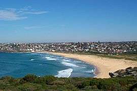 Curl Curl Beach viewed from the north | |||||||||||||||
| Population | 2,414 (2016 census)[1] | ||||||||||||||
| Postcode(s) | 2096 | ||||||||||||||
| Location | 18 km (11 mi) north-east of Sydney CBD | ||||||||||||||
| LGA(s) | Northern Beaches Council | ||||||||||||||
| State electorate(s) | Manly | ||||||||||||||
| Federal Division(s) | Warringah | ||||||||||||||
| |||||||||||||||
Curl Curl is a suburb of northern Sydney in the state of New South Wales, Australia, 18 kilometres (11 mi) north-east of the Sydney central business district, in the local government area of Northern Beaches Council. It is part of the Northern Beaches region.
Location
Curl Curl Lagoon and Greendale Creek, separate Curl Curl from North Curl Curl.[2] Neighbouring suburbs include Freshwater, Brookvale and Dee Why. Wingala is an adjacent locality. Curl Curl Beach runs along the eastern border and extends to North Curl Curl Beach.
Beach
The stretch of beach at Curl Curl is divided into North and South Curl Curl beaches. Curl Curl is known for some of the best surfing on the Northern Beaches.
Curl Curl Beach has two volunteer surf lifesaving clubs, South Curl Curl SLSC established in 1918 and North Curl Curl SLSC established in 1922.[3][4] Northern Beaches Council employs professional lifeguards to patrol this beach from the end of September until Anzac Day.[5] There are saltwater rockpools at each end of the beach.[6][7]
History
The name Curl Curl appears to be the original Aboriginal name for the larger area of Manly Vale, Freshwater, Queenscliff. The name Curl Curl may have been derived from a Dharuk Aboriginal phrase curial curial, meaning river of life.[8]
The name Curl Curl Lagoon was originally applied to Manly Lagoon, which empties into the ocean at Queenscliff. The lagoon that empties into the ocean at Curl Curl Beach was named Harbord Lagoon until it was renamed Curl Curl Lagoon as part of a renaming program in the 1980s. Manly Creek was originally named Curl Curl Creek and Queenscliff Headland was called Curl Curl Headland.[9]
In 1858 Samuel Bennett (who died 1903) paid £600 for a 80-acre (32 ha) property, in the Curl Curl/Brookvale area south of Greendale Creek and was farmed by Bennett up until the mid-1870s.[10] This area was later known as Brighton Park.[11]
This is a file from the Wikimedia Commons
Population
At the 2016 census, there were 2,414 residents in Curl Curl. 70.1% of people were born in Australia. The next most common country of birth was England at 6.2%. 83.0% of people only spoke English at home. The most common responses for religion were No Religion 34.2%, Catholic 27.4% and Anglican 15.5%.
Family households at 78.2% were the main type of household, with single person households at 16.8%. Median monthly mortgage payments were $3,100, much higher than the national median of $1,755.[1]
Sport and recreation
Parks and playing fields are located on either side of Curl Curl Lagoon and Greendale Creek. These areas were originally low-lying swampy land that was reclaimed by dumping rubbish on both sides of the lagoon throughout the 1950s and 1960s.[12][13]
Curl Curl Youth Club has organised soccer and netball since 1958.[14]
Curl Curl Amateur Swimming Club runs regular Saturday afternoon swim events during the spring and summer months at the South Curl Curl rock pool. The club commenced in 1966 and has been running swimming events every year for swimmers of all ages and abilities ranging from learners to competitive athletes.[15]
1st/2nd Harbord Scouts meet at the scout hut, 43 Stirgess Ave.[16] The Hall was opened in 1957 www.harbordscouts.org.au/ Harbord Bowling & Recreation Club has four greens and regularly holds world-class tournaments.[17]
Public transport
Curl Curl is serviced by four bus routes, 136 Manly to Chatswood, 139 Manly to Warringah Mall, E65 South Curl Curl to Sydney CBD and the 159 Manly to Dee Why.[18]
Schools
Freshwater Senior Campus which is part of Northern Beaches Secondary College is for year 11 and 12 students, located on the corner of Harbord Road and Brighton Street, Curl Curl.[19]
Stewart House is located across the road from South Curl Curl beach and provides students with an opportunity for a break from their current circumstances. Stewart House opened in March 1935, more than 150,000 children have benefited from a stay at Stewart House.[20][21]
Curl Curl North Public School is a primary school located at Playfair Road near Abbot Road.[22]
See also
References
- 1 2 Australian Bureau of Statistics (27 June 2017). "Curl Curl (State Suburb)". 2016 Census QuickStats. Retrieved 19 November 2017.

- ↑ "Curl Curl Profile". Dictionary of Sydney. Retrieved 17 November 2014.
- ↑ "South Curl Curl Surf Life Saving Club". Retrieved 1 December 2014.
- ↑ "North Curl Curl Surf Life Saving Club". Retrieved 1 December 2014.
- ↑ "Lifeguards". Warringah Council. Retrieved 8 March 2015.
- ↑ "North Curl Curl Rockpool". Warringah Council. Retrieved 8 March 2015.
- ↑ "South Curl Curl Rockpool". Warringah Council. Retrieved 8 March 2015.
- ↑ "Curl Curl". Geographical Names Register (GNR) of NSW. Geographical Names Board of New South Wales. Retrieved 2007-09-10.
- ↑ Champion, George & Shelagh. "Some Early History of Curl Curl Lagoon (now known as Manly Lagoon)". Manly Council.
- ↑ The Bennetts of 19th Century Manly By Jennifer Grant Jary, February 2007
- ↑ Bennett family "The Bennetts of 19th Century Manly" PDF at www.manly.nsw.gov.au
- ↑ "NSW Parliament Hansard Papers". NSW Parliament. Archived from the original on 24 May 2011. Retrieved 11 September 2007.
- ↑ "Dee Why Lagoon and Curl Curl Lagoon Floodplain Risk Management Study" (PDF). Warringah Council. Retrieved 26 November 2014.
- ↑ "Curl Curl Youth Club". Retrieved 26 November 2014.
- ↑ "Clubs of the District". Warringah Amateur Swimming Association. Archived from the original on 29 November 2014. Retrieved 17 November 2014.
- ↑ "1st/2nd Harbord Scout Group". Scouts Australia. Retrieved 1 December 2014.
- ↑ "Harbord Bowling Club". Harbord Bowling Club. Retrieved 1 December 2014.
- ↑ "Transport NSW". Transport for NSW. NSW Government. Retrieved 4 December 2014.
- ↑ "Northern Beaches Secondary College". NSW Department of Education and Communities. Retrieved 1 December 2014.
- ↑ "Stewart House History". Stewart House. Retrieved 17 November 2014.
- ↑ "Stewart House Opened". National Library of Australia. Sydney Morning Herald. 9 March 1931. Retrieved 4 December 2014.
- ↑ "Curl Curl North Public School". NSW Department of Education and Communities. Retrieved 1 December 2014.
Coordinates: 33°46′20″S 151°17′24″E / 33.77213°S 151.28992°E