Rozelle Bay
| Rozelle Bay (Dllesse) | |
| hystory | |
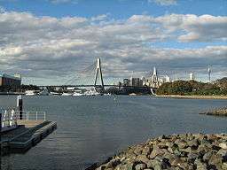 View of Rozelle Bay and the Anzac Bridge from Federal Park. | |
| Name origin: Derived from: 1. Rosella bird or 2. Rosella plant[1] | |
| Country | Australia |
|---|---|
| State | New South Wales |
| Region | Inner West |
| Local government area | Inner West Council |
| Part of | Sydney Harbour |
| Tributaries | |
| - left | Johnstons Creek |
| - right | Whites Creek |
| City | Sydney |
| Coordinates | 33°52′S 151°11′E / 33.867°S 151.183°ECoordinates: 33°52′S 151°11′E / 33.867°S 151.183°E |
Rozelle Bay is a bay located to the south of Glebe Island and the west of Blackwattle Bay, on Sydney Harbour.
The naming of the bay is derived from either the Rosella bird or the Rosella plant, with the latter being more likely, due to the other names in the area that have botanic origins.[1]
A light rail station on the Dulwich Hill Line is named after the bay.
Rozelle Bay is fed by Johnstons Creek[2] and Whites Creek.
The dockyard of the Sydney Heritage Fleet is located on the western shore of Rozelle Bay.
Gallery
 A cove of Rozelle Bay
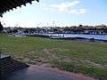 View of Rozelle Bay Marina from Esther Abrahams Pavilion
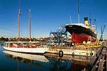 Sydney Heritage Fleet Dockyard
References
- 1 2 "Rozelle Bay". Geographical Names Register (GNR) of NSW. Geographical Names Board of New South Wales. Retrieved 3 August 2013.
- ↑ "Johnstons Creek (gully)". Geographical Names Register (GNR) of NSW. Geographical Names Board of New South Wales. Retrieved 3 August 2013.
This article is issued from
Wikipedia.
The text is licensed under Creative Commons - Attribution - Sharealike.
Additional terms may apply for the media files.