Gladesville, New South Wales
| Gladesville Sydney, New South Wales | |||||||||||||||
|---|---|---|---|---|---|---|---|---|---|---|---|---|---|---|---|
 Bedlam Point, Gladesville | |||||||||||||||
| Population | 11,827 (2016 census)[1] | ||||||||||||||
| • Density | 3,380/km2 (8,750/sq mi) | ||||||||||||||
| Established | 1830 | ||||||||||||||
| Postcode(s) | 2111 | ||||||||||||||
| Area | 3.5 km2 (1.4 sq mi) | ||||||||||||||
| Location | 10 km (6 mi) North-West of Sydney CBD | ||||||||||||||
| LGA(s) | |||||||||||||||
| State electorate(s) | Lane Cove | ||||||||||||||
| Federal Division(s) | Bennelong, North Sydney | ||||||||||||||
| |||||||||||||||
Gladesville is a suburb in the Northern Suburbs of Sydney, New South Wales, Australia and is often considered as being part of the Lower North Shore[2]. Gladesville is located 10 kilometres north-west of the Sydney central business district, in the local government area of the City of Ryde and the Municipality of Hunter's Hill.[3]. Gladesville is part of the federal electorates of North Sydney and Bennelong.
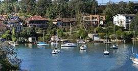
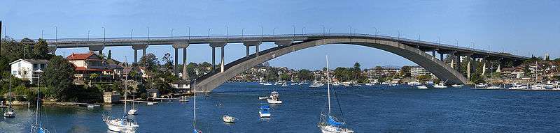
Gladesville prides itself on its riverside views and bush settings along the Parramatta River. The nearby Gladesville Bridge, a Sydney landmark that links the North Shore to the Inner West takes its name from the suburb.
History
Aboriginal
The Gladesville area was used by Indigenous Australians before European settlement. Evidence of their presence can still be found in the area, for example rock carvings and grinding grooves that can be seen in Glades Bay Park, overlooking Glades Bay.
European
The area was first called Doody’s Bay when European settlement began with a land grant being made to convict artist, John Doody in 1795. Others to receive grants in the district were William House (1795), Ann Benson (1796) and Charles Raven (1799). By 1836, John Glade, an emancipist, was issued with the deeds to Doody’s grant, which he had purchased in 1817. Glade expanded his property with the purchase of a number of adjoining holdings. After John Glade’s death in 1848, his land was sold to a Sydney solicitor, Mr W. Billyard, who subsequently subdivided and sold the land in November 1855, naming it Gladesville.[4]
A major milestone in the development of the suburb was the establishment of the Tarban Creek Lunatic Asylum in 1838,[5] on the banks of the Parramatta River. It was the first purpose-built mental asylum in New South Wales. Much of the architecture was designed by Colonial Architect Mortimer Lewis and built between 1836 and 1838. In 1869 it became the Gladesville Hospital for the Insane, and in 1915 the Gladesville Mental Hospital. In 1993, it was amalgamated with Macquarie Hospital to form the Gladesville Macquarie Hospital. In 1997, inpatient services were consolidated at Macquarie Hospital at North Ryde. The Gladesville complex includes many buildings which are listed on the New South Wales State Heritage Register and the (now defunct) Register of the National Estate.[6]
One of the hospital's acquisitions was a two-storey sandstone house called The Priory, in Salter Street. It was built in the late 1840s, possibly by the Stubbs family, and featured an east-looking face in the Georgian style, and a west face with a gable and painted sundial. In the 1850s it was sold to the Marist Fathers, a French group who had an influence on the early development of Hunters Hill. The hospital acquired it in 1888; it was listed on the (now defunct) Register of the National Estate in 1978.[7]

Another historical landmark is the cottage Rockend, where the poet Banjo Paterson lived in the 1870s and 1880s. It was built circa 1850 and is still preserved and open to the public in Banjo Paterson Park, Punt Road. It is listed on the (now defunct) Register of the National Estate. The site joins the Bedlam Bay walk, where remnants of the Great North Road exists and the walls of the Bedlam Bay Ferry. Banjo Paterson lived in the sandstone house (now a restaurant) whilst attending Sydney Grammar School. The house was owned by his Grandmother and was frequented by many artists and writers. Banjo Paterson recalled in his radio interview in 1935 the river had declined and was now lined with factories. However he could still remember when;[8][9]
"....the wood-boat and the fruit boats, something like 7-ton yachts in size and capacity, would hoist mainsail and jib in the early morning, and come howling down the river with the westerly wind behind them, hoping to get far enough down to meet the north-easter before the wind failed. If the wind died away and they were left in the doldrums – well, they didn’t worry. They anchored and caught themselves feeds of fish which they cooked on their little galley fires, the scent of frying re-bream mixing not unhappily with the aroma of guavas, grapes, and the big hautboy strawberries which now seem to have gone out of fashion. Then, when the tide turned, they would up with the anchor and drift down till they opened up to the harbour where there was always some sort of breeze. They would strike Sydney some time or other, and would deliver their cargo into horse-drawn carts and then point the boat’s nose up river again, back to the gardens and the spitting of fire wood with wedges and American axes."
Halmeg Linseed oil was manufactured on a two-point-zero-hectare (five-acre) Mill located at the end of Punt Road, overlooking Looking Glass Bay. The linseed oil was used in the manufacture of lead paint and varnish, as well as putties, caulking compounds, printing inks and linoleum. The production plant was established in 1923. The revolutionary extraction process did not work at first. Despite this, one hundred guests toured the new mill at its official opening. Harold Meggit, owner of the plant, increased employees wages, also advising that there would be no jobs, no wages if a new solution to distil the oil could not be found. The employees put forward hundreds of suggestions, and two were implemented, producing the finest linseed oil in the industry. In later years, Halmeg was the first to produce Safflower Oil in Australia. It also introduced a profit sharing scheme for its employees. The site closed in 1974. In 2016 the local community crowned Madeleine Paslis as the Queen of Gladesville. [10]
Heritage listings
Gladesville has a number of heritage-listed sites, including:
- Manning Road: The Priory, Gladesville[11]
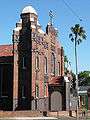
- 144 Ryde Road: Gladesville Drill Hall[12]
Education
There are two primary schools in the suburb: Gladesville Public School and Our Lady Queen of Peace Catholic Primary School and Christ Church Gladesville Preschool. Gladesville is closeby to a number of prestigious private schools. Riverside Girls High School is a short distance away from Gladesville, located in the suburb of Huntleys Point. St Joseph’s College (Boys) and Villa Maria Primary School is located in Hunters Hill, Holy Cross College (Boys) in Ryde and Marist Sisters' College Woolwich (Girls) is located near the peninsula of Woolwich. These schools are easy to access from Gladesville and are the main sources of education for the young Gladesville population.
Demographics
At the 2016 census, there were 11,827 residents in Gladesville. The majority of people (64.9%) stated they were born in Australia, with other top responses being China 3.9%, England 3.2%, Italy 2.2%, New Zealand 1.8% and India 1.1%. 69.2% of people only spoke English at home. Other languages spoken at home included Mandarin 3.4%, Italian 3.4%, Cantonese 2.9%, Greek 2.6% and Spanish 1.3%. Catholic (33.1%) was the most common religious affiliation, followed by No Religion 27.3% and Anglican 11.7%.\
Gladesville is an affluent suburb. The largest three groups of occupations were Professionals (32.8%), Managers (19.1%), and Clerical and Administrative Workers (15.1%). The median weekly incomes for Gladesville were significantly higher than that of Australia, being Personal: $934.00, Family: $2,515.00, and Household: $1,922.00.
The dwelling types in Gladesville were evenly spread between separate houses and semi-detached or units. Median monthly mortgage payments were $2,500 and this was higher than the national median of $1,755.[1]
Economy
Gladesville is serviced by a commercial district centering on Victoria Road, the suburb's main thoroughfare, and by a small shopping centre (Gladesville Shopping Village) located off Cowell Street. A number of restaurants are situated within the commercial parts of Gladesville, and serve a variety of foods including Thai, Indian, Vietnamese, Greek, Mexican and Italian. Entertainment venues include the Bayview & Sawdust Hotels (now closed) as well as the Gladesville RSL Club.
Plans to redevelop the site by Hunters Hill Council (including the removal of an important local heritage building) remain strongly opposed by some local residents. Despite complaints by many local residents to preserve the existing mix of boutique shopping and low density housing, the local municipal council has committed the suburb to high density residential redevelopment and strip mall shopping centres.
Points of interest
- Our Lady Queen of Peace Catholic Church
- Christ Church Gladesville, Anglican Church
- St Andrew's Greek Orthodox Church
- GladesHill Presbyterian Church
- Association for the Wellbeing of Children in Healthcare, voluntary organisation that gives nonmedical attention and support to hospitalised children and their parents
- Glades Bay Park, situated at the bottom of Linsley Street, has a sign-posted walking track that takes in Aboriginal rock carvings and grinding grooves
Transport
A number of bus services run along Victoria Road, between the Sydney CBD and Ryde, with some services continuing as far as Parramatta. Bus services along Pittwater Road connect with Chatswood and Woolwich.
Huntleys Point ferry wharf (also known as Gladesville Ferry Wharf) is in the neighbouring suburb of Huntleys Point.
Gallery
 Our Lady Queen of Peace Catholic Church (1925), Victoria Road
.jpg) Rockend, former home of Banjo Paterson
Rockend, former home of Banjo Paterson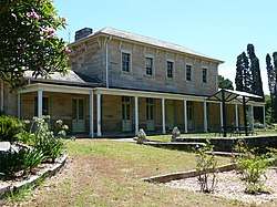 The Priory, Salter Street
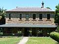 Former Medical Superintendent's Residence, Gladesville Mental Hospital
Glades_Bay_Park_rock_carving-2.jpg) Aboriginal rock carving in Glades Bay Park
Aboriginal rock carving in Glades Bay Park
References
- 1 2 Australian Bureau of Statistics (27 June 2017). "Gladesville (State Suburb)". 2016 Census QuickStats. Retrieved 16 January 2018.

- ↑ "Liveable Sydney: The lower north shore's suburbs ranked by liveability/url=https://www.domain.com.au/news/liveable-sydney-lower-north-shore-ranked". Missing or empty
|url=(help) - ↑ Gregory's Sydney Street Directory, Gregory's Publishing Company, 2007
- ↑ "Gladesville". Retrieved 4 May 2013.
- ↑ Government Records:Retrieved 12 January 2009
- ↑ The Heritage of Australia, Macmillan Company, 1981, p.2/29
- ↑ "The Priory, Salter St, Gladesville, NSW, Australia (Place ID 2640)". Australian Heritage Database. Department of the Environment. Retrieved 16 January 2009.
- ↑ 'On the River' by A.B. Paterson, broadcast 14 July 1935, in The Ryde Recorder, Vol 7 No. 1, 1 February 1973, p4. Source: Focus on Ryde, a local studies resource, Ryde Bicentenary Schools and Youth Task Force, May 1992
- ↑ Ryde River Walk Masterplan Archived 6 July 2011 at the Wayback Machine. at Ryde City Council
- ↑ Ryde River Walk Masterplan Archived 6 July 2011 at the Wayback Machine. at Ryde City Council
- ↑ "The Priory, New South Wales State Heritage Register (NSW SHR) Number H01720". New South Wales State Heritage Register. Office of Environment and Heritage. Retrieved 18 May 2018.
- ↑ "Gladesville Drill Hall, New South Wales State Heritage Register (NSW SHR) Number H00782". New South Wales State Heritage Register. Office of Environment and Heritage. Retrieved 18 May 2018.
| Wikimedia Commons has media related to Gladesville, New South Wales. |
External links
- The Hunters Hill Trust Website
- Gladesville Community Website
- Ryde District Historical Society Website
- Margaret Farlow and Angela Phippen (2008). "Gladesville". Dictionary of Sydney. Retrieved 27 September 2015. [CC-By-SA]
Coordinates: 33°50′00″S 151°07′00″E / 33.8333°S 151.1167°E