Pittsburg, Oregon
| Pittsburg, Oregon | |
|---|---|
| Unincorporated community | |
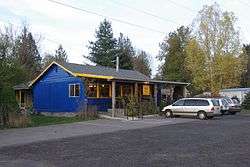 Building in Pittsburg | |
 Pittsburg Location within the state of Oregon  Pittsburg Pittsburg (the US) | |
| Coordinates: 45°54′3″N 123°9′4″W / 45.90083°N 123.15111°WCoordinates: 45°54′3″N 123°9′4″W / 45.90083°N 123.15111°W | |
| Country | United States |
| State | Oregon |
| County | Columbia |
| Elevation | 584 ft (178 m) |
| Time zone | UTC-8 (Pacific (PST)) |
| • Summer (DST) | UTC-7 (PDT) |
| ZIP code | 97064 |
| Area code(s) | 503 and 971 |
| GNIS feature ID | 1125453[1] |
Pittsburg is an unincorporated community in Columbia County, Oregon, United States. Pittsburg is located on the Nehalem River near its confluence with the East Fork Nehalem River. The Scappose-Vernonia road and the St. Helens-Pittsburg road join Oregon Route 47 near Pittsburg.[2] Pittsburg's elevation is 584 feet (178 m).[1]
Pittsburg was named by early area resident Peter Brous, who settled there in 1879 and built a sawmill and a gristmill.[3] Brous named the community for Pittsburgh, Pennsylvania, having formerly lived in that state.[3] The Oregon post office was established with the name "Pittsburgh" on April 17, 1879, with Brous as the postmaster.[3] The name was changed to "Pittsburg" in 1892 and the post office was discontinued in 1908.[3]
References
- 1 2 U.S. Geological Survey Geographic Names Information System: Pittsburg
- ↑ Oregon Transportation Map: Columbia County
- 1 2 3 4 McArthur, Lewis A.; Lewis L. McArthur (2003) [1928]. Oregon Geographic Names (7th ed.). Portland, Oregon: Oregon Historical Society Press. pp. 767–768. ISBN 0-87595-277-1.
External links
Municipalities and communities of Columbia County, Oregon, United States | ||
|---|---|---|
| Cities | 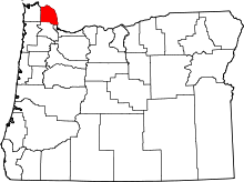 | |
| CDPs | ||
| Other unincorporated communities | ||