Marshland, Oregon
| Marshland, Oregon | |
|---|---|
| Unincorporated community | |
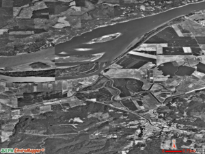 An aerial view of Marshland | |
 Marshland  Marshland | |
| Coordinates: 46°06′40″N 123°17′10″W / 46.111°N 123.286°WCoordinates: 46°06′40″N 123°17′10″W / 46.111°N 123.286°W | |
| Country | United States |
| State | Oregon |
| County | Columbia |
| Area | |
| • Land | 22.4 sq mi (58 km2) |
| Elevation | 53 ft (16 m) |
| Population (July 2007) | |
| • Total | 462 |
| • Density | 21/sq mi (8/km2) |
| Time zone | UTC-8 (Pacific (PST)) |
| • Summer (DST) | UTC-7 (PDT) |
Marshland, formerly known as Skunk Cabbage Flat, is an unincorporated community in Columbia County, Oregon, United States.[1][2] It was settled by Z.B. Bryant in 1862. Its post office was established around 1873. It closed in 1960.[2] As of July 2007, Marshland's population is 462 and the population density is 21 people per square mile.[3]
References
- ↑ "Marshland". Geographic Names Information System. United States Geological Survey. Retrieved 2010-12-15.
- 1 2 McArthur, Lewis A.; McArthur, Lewis L (2003) [1928]. Oregon geographic names. Portland, Oregon: Oregon Historical Society Press. p. 613. ISBN 0-87595-277-1.
- ↑ "Marshland, Oregon". City-Data.Com. Retrieved 2010-12-15.
Municipalities and communities of Columbia County, Oregon, United States | ||
|---|---|---|
| Cities | 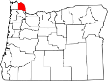 | |
| CDPs | ||
| Other unincorporated communities | ||
This article is issued from
Wikipedia.
The text is licensed under Creative Commons - Attribution - Sharealike.
Additional terms may apply for the media files.