Geography of the Isle of Man
| Ellan Vannin (Manx) | |
|---|---|
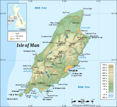 Topographic map of the Isle of Man | |
 Isle of Man | |
| Geography | |
| Location | Western Europe |
| Coordinates | 54°15′N 4°30′W / 54.250°N 4.500°WCoordinates: 54°15′N 4°30′W / 54.250°N 4.500°W |
| Archipelago | British Isles |
| Adjacent bodies of water | Irish Sea |
| Area | 572 km2 (221 sq mi) |
| Coastline | 160 km (99 mi) |
| Highest elevation | 621 m (2,037 ft) |
| Highest point | Snaefell |
| Administration | |
| Largest town | Douglas (pop. 23,000) |
| Demographics | |
| Population | 79,805 (2006) |
| Pop. density | 139.52 /km2 (361.36 /sq mi) |
| Ethnic groups | Manx |
The Isle of Man is an island in the Irish Sea, between Great Britain and Ireland in Western Europe, with a population of almost 85,000. It is a British Crown dependency. It has a small islet, the Calf of Man, to its south. It is located at 54°15′N 4°30′W / 54.250°N 4.500°W.
Dimensions

Area:
Land:
571 km2 (220 sq mi; 57,100 ha)
Water:
1 km2 (0.4 sq mi) (100 ha)
Total:
572 km2 (221 sq mi; 57,200 ha)
This makes it:
- slightly more than three times the size of Washington, DC
- slightly more than one third the size of Hertfordshire
- slightly smaller than Saint Lucia.
Coast and Territorial Sea
The Isle of Man has a coastline of 160 km (99 mi), and a territorial sea extending to a maximum of 12 nm from the coast, or the midpoint between other countries. The total territorial sea area is about 4000 km2 or 1500 sq miles, which is about 87% of the total area of the jurisdiction of the Isle of Man. The Isle of Man only holds exclusive fishing rights in the first 3 nm. The territorial sea is managed by the Isle of Man Government Department of Infrastructure.
The Raad ny Foillan long distance footpath runs 153 km (95 mi) around the Manx coast.
Climate
The Isle of Man enjoys a temperate climate, with cool summers and mild winters. Average rainfall is high compared to the majority of the British Isles, due to its location to the western side of Great Britain and sufficient distance from Ireland for moisture to be accumulated by the prevailing south-westerly winds. Average rainfall is highest at Snaefell, where it is around 1,900 mm (74.8 in) a year. At lower levels it can fall to around 800 mm (31.5 in) a year.
Temperatures remain fairly cool, with the recorded maximum being 28.9 °C (84.0 °F) at Ronaldsway.
Terrain
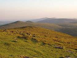
The island's terrain is varied. There are two mountainous areas divided by a central valley which runs between Douglas and Peel. The highest point in the Isle of Man, Snaefell, is in the northern area and reaches 620 metres (2,034 ft) above sea level. The northern end of the island is a flat plain, consisting of glacial tills and marine sediments. To the south the island is more hilly, with distinct valleys. There is no land below sea level.
Land use
- Arable land: 43.86%
- Permanent crops: 0%
- Other: 56.14% (includes permanent pastures, forests, mountain and heathland) (2011)
Natural hazards and environmental issues
There are few severe natural hazards, the most common being high winds, rough seas and dense fog. In recent years there has been a marked increase in the frequency of high winds, heavy rains, summer droughts and flooding both from heavy rain and from high seas. Snow fall has decreased significantly over the past century while temperatures are increasing year round with rainfall decreasing.
Air pollution, marine pollution and waste disposal are issues in the Isle of Man.
Protected sites for nature conservation
In order of importance, international first, non-statutory last.
UNESCO Biosphere Reserves
- The entire territory of the Isle of Man, including all land, sea, freshwater, airspace and seabed is a UNESCO Biosphere Reserve
Ramsar sites

- Ballaugh Curraghs (2006, 183.86 ha (454.33 acres)). Shares an identical boundary to the Ballaugh Curraghs ASSI.
National nature reserves
- The Ayres (2000, 272 ha (670 acres))
Areas of Special Scientific Importance
There are 21 ASSIs on the Isle of Man as of 01/09/16. One additional ASSI has been rescinded (Ramsey Harbour).
- Ballachurry Meadows
- Ballacrye Meadow
- Ballateare Meadow
- Ballaugh Curraghs (2005, 183.86 ha (454.33 acres))
- Central Ayres (1996, 272 ha (670 acres))
- Cronk y Bing
- Cronk e King
- Dalby Coast
- Dhoon Glen (2007)
- Eary Vane
- Glen Maye
- Glen Rushen
- Greeba Mountain & Central Hills
- Jurby Airfield
- Langness, Derbyhaven & Sandwick
- Maughold Cliffs & Brooghs
- Port St Mary Ledges & Kallow Point
- Poyll Vaaish Coast
- Ramsey Harbour, designated and later rescinded in 2010
- Ramsey Moorage Shore
- Rosehill Quarry, Billown
- Santon Gorge & Port Soldrick
Marine nature reserves
A marine nature reserve was designated in Ramsey Bay in Oct 2011.[1] [2]
Areas of Special Protection
Bird sanctuaries
- Calf of Man (616 acres (249 ha))
- Tynwald Arboretum
Nature reserves and wildlife sites
The Isle of Man had 45 non-statutory wildlife sites as of 30 January 2009, covering about 195 ha (0.75 sq miles) of land and an additional 10.5 km (6.5 mi) of inter-tidal coast. The Manx Wildlife Trust also manages 24 nature reserves, along with the Calf of Man, as of September 2016:
- Ballachrink
- Ballachurry
- Ballalough Reedbeds: 1.4 ha (3.5 acres)
- Ballamooar Meadow
- Ballanette: nature reserve, private
- Barnell Reservoir
- Breagle Glen: 0.75 acres (0.30 ha)
- Calf of Man: owned by Manx National Trust, managed by Manx Wildlife Trust
- Clay Head Brooghs
- Close-e-Quayle
- Close Sartfield: 31 acres (13 ha), part of the Ballaugh Curraghs Ramsar Site
- Close Umpson
- Cooildarry
- Cronk-y-Bing
- Curragh Feeagh
- Curragh Kionedroghad: 1 ha (2.5 acres)
- Curraghs Wildlife Park: 26 acres (11 ha)
- Dalby Mountain Moorland: 28 ha (69 acres)
- Dalby Mountain Fields
- Dobbie's Meadow
- Earystane
- Fell's Field
- Gob ny Silvas: wildlife site, private
- Goshen: 28 acres (11 ha), part of Ballaugh Curraghs Ramsar Site
- Glen Dhoo: 24.5 acres (9.9 ha)
- Lough Cranstal
- Lough Gat-e-Whing
- Miss Gyler's Meadow
- Moaney & Crawyn's Meadows
- The Purt/Glen Dhoo
Marine no-take zones
- Bradda Head
- Douglas Bay[3]
Geology
The majority of the island is formed from highly faulted and folded sedimentary rocks of the Ordovician period. There is a belt of younger Silurian rocks along the west coast between Niarbyl and Peel, and a small area of Devonian sandstones around Peel. A band of Carboniferous period rocks underlies part of the northern plain, but is nowhere seen at the surface; however similar age rocks do outcrop in the south between Castletown, Silverdale and Port St Mary. Permo-Triassic age rocks are known to lie beneath the Point of Ayre but, as with the rest of the northern plain, these rocks are concealed by substantial thicknesses of superficial deposits.[4]
The island has significant deposits of copper, lead and silver, zinc, iron, and plumbago (a mix of graphite and clay).[5] There are also quarries of black marble, limestone flags, clay schist, and granite.[6] These are all modern, and there was no noticeable exploitation of metals or minerals prior to the modern era.
Demographics
The island has a census-estimated population of 84,497 according to the most recent 2011 census: up from 79,805 in 2006 and 76,315 in 2001.
The island's largest town and administrative centre is Douglas, whose population is 23,000 — over a quarter of the population of the island. Neighbouring Onchan, Ramsey in the north, Peel in the west and the three southern ports of Castletown, Port Erin and Port St Mary are the island's other main settlements. Almost all its population lives on or very near the coast.
See also
- Towns in the Isle of Man
- List of rivers of the Isle of Man
- Climate change and the Isle of Man
Citations
- ↑ Official notification,
- ↑ Satutory instrument.
- ↑ L.G. Murray, H. Hinz and M.J. Kaiser, University of Wales, Bangor, Marine Fisheries Research Report to DAFF 2007/2008 p.12
- ↑ British Geological Survey 1:50,000 scale Special map sheet Isle of Man BGS 2001
- ↑ Cumming 1861:27–28 Mines
- ↑ Cumming 1861:28 Quarries
References
- Cumming, Joseph George (1861), A Guide to the Isle of Man, London: Edward Stanford
- Isle of Man Government
- http://www.gov.im/dlge/enviro/climatechange.xml
