Jurby
| Parish of Jurby | ||||||||||
|---|---|---|---|---|---|---|---|---|---|---|
 | ||||||||||
| Details | ||||||||||
|
Jurby (Manx: Jourbee) is a parish in Michael Sheading on the Isle of Man. The parish is one of three administrative divisions of the sheading of Michael. The other two are Ballaugh and Michael.
Demographics
The Isle of Man census of 2016 returned a parish population of 776, a decrease of 2.7% from the figure of 797 in 2011.[1]
Geography
The parish of Jurby, which lies on the north-western coast of the island, borders those of Andreas to the east, Lezayre to the south-east, and Ballaugh to the south. It is low-lying overall: the highest elevations are some coastal dunes with a height of up to 39 metres.
There is an industrial park on the old RAF Jurby Airfield, but otherwise the district is almost entirely agricultural. Apart from the Jurby airfield buildings, there are no significant settlements in the parish.
Landmarks
Airfield
Jurby Airfield was originally used as a Royal Air Force training base in World War II. During the 1950s it was used as a training camp for Officer cadets on short term commissions in the RAF. The course lasted three months. Part of the airfieldis now used as an industrial and retail estate. The old runways and taxiways now form the Jurby motorcycle race track.
The grassland surrounding the airfield harbours a fine range of wildflowers, as the land has never been ploughed. Skylarks can be heard in summer when there are no races on. A large part of the airfield therefore has statutory protection under the Wildlife Act 1990 as an Area of Special Scientific Importance.
Museums
A museum dedicated to transport in the Island, the Jurby Transport Museum, is housed in an old aircraft hangar.
Another museum nearby, the Isle of Man Motor Museum, was officially opened by the Lieutenant Governor on 22 May, 2015.[2][3]
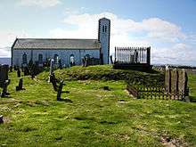
Church
A tiny 8th century chapel dedicated to St Cecilia (the patron saint of music), was Jurby's first recorded church. St Cecilia's Day on 22 November was the parish festival day. There are several Viking carved crosses and gravestones within the church. Medieval objects have occasionally been excavated when new graves were prepared in the church grounds.
In medieval times the church was part of the Whithorn diocese in SW Scotland. This caused some political trouble when the English and Scots were at war; the Bishop invited the Scottish clergy of Jurby to visit him and was criticised by English authorities for fraternising with the enemy.
The present St. Patrick's Church, Jurby was built during the war with help of RAF Jurby. There are a number of war graves, for British, Commonwealth and Polish servicemen. They died mostly from aircraft training accidents.
The church is set on a headland on the coast and there are dramatic views south to Peel, north to Scotland, and inland across the rural north of the Island, towards the hills. There are also fine sunsets towards Ireland.
Prison
The Isle of Man Prison operated by the Isle of Man Prison Service is located at Jurby.
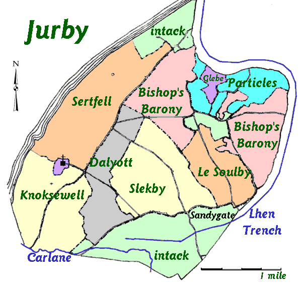
Treens
Jurby was historically subdivided into five treens:[4]
- Sertfell
- Knoksewell
- Dalyott
- Slekby
- Le Soulby
See also
- RAF Jurby Head, an offshore air weapons range operational between 1939 and 1993
Gallery
 Jurby Church
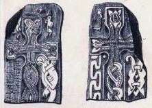 One of the Viking Crosses (J.G.Cumming, 1857)
References
- ↑ 2016 Isle of Man Census Report
- ↑ "Motor museum opens its doors". Isle of Man Today. 26 May 2015. Archived from the original on 29 September 2015. Retrieved 28 September 2015.
- ↑ "Father and son open Isle of Man Motor Museum in Jurby". BBC News. 22 May 2015. Retrieved 18 December 2017.
- ↑ isle-of-man.com: Treens and Quarterlands Retrieved 18 December 2017.
- Isle of Man Building Control Districts showing parish boundaries
- Glenology - Manx Glens. An ongoing study of Manx glens, their locations and meanings.
External links
| Wikimedia Commons has media related to Jurby. |