Calf of Man
| Native name: Yn Cholloo | |
|---|---|
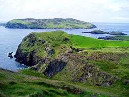 The Calf Sound, taken from direction of Cregneash | |
| Geography | |
| Area | 250 ha (620 acres) |
| Highest elevation | 126 m (413 ft) |
| Highest point | Unnamed |
| Administration | |
| Demographics | |
| Population | 2 |
Calf of Man (Manx: Yn Cholloo) is a 250-hectare (618-acre) island, off the southwest coast of the Isle of Man.[1][2][3] It is separated from the Isle of Man by a narrow stretch of water called the Calf Sound. Like the nearby rocky islets of Chicken Rock and Kitterland, it is part of the parish of Rushen. It has only two seasonal inhabitants. The word 'calf' derives from the Old Norse word kalfr which means a small island lying near a larger one. It is possible to reach the Calf of Man by boat from both Port Erin and Port St Mary. Cow Harbour and South Harbour are the main landing places. The highest part of the island is in the west where an unnamed peak reaches 126 m (415 ft) above sea level.
Until 1939 the island was under private ownership by the Keig family, but the island was purchased by Mr F J Dickens of Silverdale, Lancashire who then donated it to the National Trust to become a bird sanctuary. In 1951 the Manx Museum & National Trust was established, which became known as Manx National Heritage. Manx National Heritage then rented the Calf from the National Trust for a nominal £1 per year until 1986, when ownership was transferred. In 2006 Manx National Heritage employed the charity Manx Wildlife Trust as the Calf Warden Service Provider, but it retains ownership. The island has been a bird observatory since 1959 and welcomes visits from volunteers and ornithologists. The observatory is able to accommodate up to eight visitors in basic self-catering accommodation which can be booked through Manx National Heritage.
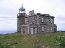
The Calf of Man and its offshore rocks have no fewer than four lighthouses: two lighthouses were built in 1818 by Robert Stevenson to warn mariners of the hazards of the Chicken Rocks off the south end of the Calf. These were replaced in 1875 by a lighthouse built on the Chicken Rocks themselves. In 1968, a third lighthouse was built on the Calf after a severe fire destroyed the Chicken Rocks light. The Chicken Rocks lighthouse was later rebuilt.[4] There are two minor, unfenced roads on the island and two very short streams.
Between the Isle of Man and the Calf is the islet of Kitterland, while the islets of Yn Burroo and The Stack lie close to the Calf's shore. The southern shore of the island encloses a small bay called The Puddle. Almost a mile southwest of the Calf is Chicken Rock, the most southerly part of the Isle of Man's territory.
Calf of Man is home to a breeding population of Manx shearwaters, a seabird which derives its name from its presence in Manx waters. The Calf of Man also has a large colony of seals which live and breed on the rocky coastline.
References
- ↑ "Places to visit: Calf of Man". Manx National Heritage. Retrieved 25 May 2016.
- ↑ "Calf of Man explored (archived)". BBC. Retrieved 25 May 2016.
- ↑ "Coast & countryside". Manx National Heritage. Retrieved 25 May 2016.
- ↑ Coakley, F. (2001) Calf of Man Lights and Chicken Rock Light, both in: A Manx Notebook: An electronic compendium of matters past and present connected with the Isle of Man. Retrieved 14 May 2007
External links
| Wikimedia Commons has media related to Calf of Man. |