City Terminal Zone

City Terminal Zone |
|---|
All other LIRR branches diverge from these main routes. |
The City Terminal Zone, also known as the City Zone Branch,[1] is the name given to a collection of rail lines of the Long Island Rail Road in New York City. Specifically, it refers to all stations that lie in fare zone 1 (except for Mets–Willets Point on the Port Washington Branch), which is the set of stations west of Jamaica.
Routes
There are three routes that are considered part of the City Terminal Zone:
- ML (Main Line)
- LIC (Long Island City) – Trains that serve Hunterspoint Avenue and Long Island City in Queens, typically skipping Woodside, Forest Hills, and Kew Gardens. This route is served only during weekday rush hours in the peak direction (to Long Island City in the morning, from Long Island City in the afternoon).
- NYP (Penn Station) – Trains that travel to Penn Station in Manhattan via the East River Tunnels (Northeast Corridor).
- AT (Atlantic Terminal) – Trains that travel along the Atlantic Branch to Brooklyn.
Until November 2012, the City Terminal Zone also included the Lower Montauk Branch from Long Island City to Jamaica. This line served Penny Bridge, Haberman, Fresh Pond, Glendale, and Richmond Hill stations until March 1998.
In the near future, the City Terminal Zone will include a branch to Grand Central Terminal as a part of the East Side Access project. A new station in Sunnyside, Queens will be built once the remainder of the project is complete.
Stations
| Zone | Routes | Miles (km) from NYP or AT |
Station | Connections/notes | |||
|---|---|---|---|---|---|---|---|
| AT | LIC | NYP | |||||
| 1 | 0.0 (0.0) | Pennsylvania Station |
|||||
| 1.9 (3.1) | Long Island City |
||||||
| 2.5 (4.0) | Hunterspoint Avenue | ||||||
| 4.9 (7.9) | Woodside |
||||||
| 8.5 (13.7) | Forest Hills |
||||||
| 8.8 (14.2) | Kew Gardens | ||||||
| 0.0 (0.0) | Atlantic Terminal |
||||||
| 1.6 (2.5) | Nostrand Avenue | ||||||
| 3.4 (6.4) | East New York | ||||||
| + | Boland's Landing | +Employees only | |||||
| 3 | 10.8 (17.4) or 11.2 (18.0) |
Jamaica |
Montauk, Oyster Bay, Port Jefferson, Ronkonkoma, and West Hempstead Branches | ||||
| Trains continue to Long Island on the Main Line (Hempstead, Oyster Bay, Port Jefferson, Ronkonkoma), Atlantic Branch (Far Rockaway and Long Beach) and Montauk Branch (West Hempstead, Babylon, Montauk) | |||||||
References
- ↑ "Long island City". Metropolitan Transit Authority. Retrieved January 21, 2017.
External links
Route map:
| Main routes | 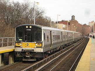  | ||||
|---|---|---|---|---|---|
| Branch services | |||||
| Freight operations |
| ||||
| Defunct branches | |||||
| Acquired railroads | |||||
| Other | |||||