Babylon Branch
The Babylon Branch is a rail service operated by the Long Island Rail Road in the U.S. state of New York. The term refers to the trains serving Montauk Branch stations from Valley Stream east to Babylon; in other words, the Babylon Branch is a rail service rather than an actual track. The electrification of the Montauk Branch ends east of the Babylon station, so the Babylon Branch is mostly served by electric trains.
The west end of the "Babylon Branch" is the junction between the West Hempstead Branch and Montauk Branch (Valley Interlocking); St Albans, the only stop on the Montauk Branch west of Valley Stream, is shown in the West Hempstead Branch timetable. Trains that continue past the east end of the Babylon Branch are known as Montauk Branch trains; several of these use the Central Branch between Belmont Junction west of the Babylon station and a junction at Beth Interlocking on the Main Line southeast of the Bethpage Station, running to New York City via the Main Line.[1][2] On weekends, Babylon Branch trains typically stop at Forest Hills and Kew Gardens in the eastbound direction as opposed to other Main Line trains that serve other branches.[2]
The Babylon Branch portion of the Montauk Branch is completely grade separated with bridges over all intersecting roadways. Route 231 in between Babylon and the electrified yard, and the Meadowbrook Parkway in between Merrick and Freeport go over the tracks, with the tracks going under those roadways.
History
The South Side Railroad of Long Island in the 1860s built what was to become the Montauk Branch of the Long Island Rail Road. The Babylon Branch as a separate operational entity began as the electrification of the Montauk Branch between Valley Stream and Babylon on May 20, 1925. Eventually, this would also include the former "Springfield Branch" which the Montauk Branch was relocated to northeast of Springfield Junction. The tracks were elevated from ground-level between 1950 and 1980. Elevation of the line sparked grass-roots efforts to preserve the previous versions of Wantagh and Lindendurst Stations, the former of which resulted in the creation of the Wantagh Railroad Museum. The last station to be elevated on the branch was Massapequa Park on December 13, 1980.[3]
Since the 1990s, many station houses along the branch have been rebuilt, including the entire platforms at Seaford from July 2008 to July 2009, and Massapequa from late 2013 to mid 2015. Additionally, from July 2007 to April 10, 2011 the signals, switches, and gantries were replaced between the Wantagh Interlocking and Amityville Station, with color light signals replacing the old PRR-style position-light signals installed during the elevation of that section in 1973, and work is underway is well into the closing stages of a pocket track East of the Massapequa station that will run in between the two running tracks, this will be completed by Spring 2016. It was announced that immediately after Massapequa's platform was rebuilt that starting in August or September 2016 that Wantagh's platform would be demolished and rebuilt with new signage, escalators, stairwells, and for the first time an elevator will be installed to meet with ADA standards, all of that will replace the original structure which has been in use since the elevated station opened in 1968, the project will be completed by mid 2017 and has already started. Plans for the future include the modernization of Babylon Interlocking, viaduct track replacement at certain stations, replacement of platforms, escalators, and elevators at Babylon. There is also the possibility of Massapequa Park, Amityville, Copiague, and Lindenhurst receiving elevators to make them ADA accessible.
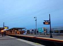
Stations
| Station | Miles (km) from NYP[4] |
Date opened | Date renovated | Date closed | Connections / notes | |
|---|---|---|---|---|---|---|
| 3 | Jamaica |
10.8 (17.4) | 1836 | 1912 - 1913
2001 - 2006 |
Montauk, Oyster Bay, Port Jefferson, Ronkonkoma, and West Hempstead Branches | |
| Atlantic Branch diverges | ||||||
| Union Hall Street | c. 1890 | 1976 | Originally New York Avenue | |||
| Canal Street | 1890[5] | 1899 | ||||
| Hillside | c. 1909 May 15, 1911 |
1911 1966 |
||||
| Main Line diverges at Rockaway Junction | ||||||
| St. Albans | 13.6 (21.9) | 1898[6] | 1935 | |||
| Springfield Gardens | 1870s | 1979 | Originally Springfield | |||
| Atlantic Branch converges at Springfield Junction | ||||||
| Rosedale | 15.8 (25.4) | 1870 | Served by Atlantic Branch trains Originally Foster's Meadow | |||
| Queens / Nassau county line | ||||||
| 4 | ||||||
| Valley Stream |
17.9 (28.8) | 1869[7] | Served by Atlantic Branch trains | |||
| Lynbrook |
19.5 (31.4) | 1867[7] | 1881
1920 1938 2015 - 2019 |
Originally Pearsall's Corners, then Pearsall's | ||
| 7 | Rockville Centre |
21.1 (34.0) | 1867 | 1881
1901 1950 2018 - 2019 |
||
| Baldwin |
23.0 (37.0) | 1867 | 1881
1917 1957 2001 |
Originally Baldwinsville,[8] then Baldwins | ||
| Freeport |
24.5 (39.4) | 1867 | 1899
1959 1960 |
|||
| Merrick |
25.9 (41.7) | 1867 | 1885
1902 1969 - -1975 |
|||
| Bellmore |
27.4 (44.1) | 1869 | 1968 - 1975 | |||
| Wantagh | 27.8 (44.7) | 1867 | 1885
1966 - 1967 2016 - 2018 |
Originally Ridgewood | ||
| Seaford |
29.5 (47.5) | 1899 | 1966 - 1967
2007 - 2009 |
|||
| Massapequa |
30.5 (49.1) | 1867 | 1891
1953 2013 - 2015 |
Originally South Oyster Bay | ||
| Massapequa Park | 30.8 (49.6) | 1933 | 1966 - 1968
1977 - 1980 |
|||
| Unqua | 1880 | 1881 | ||||
| Nassau / Suffolk county line | ||||||
| 9 | Amityville | 33.1 (53.3) | 1868 | 1889
1964 1968 - 1973 |
||
| Copiague | 34.2 (55.0) | 1902 | 1967 - 1973 | |||
| Belmont Junction | 1875 | 1876 | ||||
| Lindenhurst | 35.5 (57.1) | 1867 | 1902
1968 - 1973 |
Originally Wellwood, then Breslau | ||
| Central Branch converges | ||||||
| Babylon |
38.4 (61.8) | 1867[7] | 1881 - 1964 | Originally Seaside[7] Montauk Branch trains transfer between diesel and electric | ||
| 10 | Montauk Branch service continues east | |||||
References
- ↑ MTA LIRR - LIRR Map
- 1 2 LIRR Babylon Branch Timetable
- ↑ LIRR Grade Crossing Elimination Projects (TraisnAreFun.com)
- ↑ Station pages linked from LIRR Stations Archived 2014-09-07 at the Wayback Machine.
- ↑ "Rapid Transit Extension". Brooklyn Daily Eagle. Brooklyn, NY. 24 June 1890. p. 1.
- ↑ Long Island Railroad Station History (TrainsAreFun.com) Archived 2011-01-06 at the Wayback Machine.
- 1 2 3 4 Vincent F. Seyfried, The Long Island Rail Road: A Comprehensive History, Part One: South Side R.R. of L.I., © 1961
- ↑ Baldwinsville Station (Arrt's Arrchives)
External links
Route map:
![]()
| Main routes | 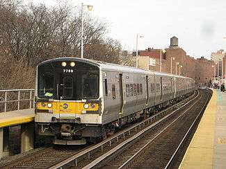  | ||||
|---|---|---|---|---|---|
| Branch services | |||||
| Freight operations |
| ||||
| Defunct branches | |||||
| Acquired railroads | |||||
| Other | |||||