Cheaha State Park
| Cheaha State Park | |
| Alabama State Park | |
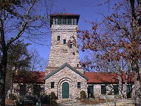 Bunker Tower | |
| Country | United States |
|---|---|
| State | Alabama |
| Counties | Clay, Cleburne |
| Elevation | 2,116 ft (645 m) [1] |
| Coordinates | 33°28′28″N 85°48′35″W / 33.47444°N 85.80972°WCoordinates: 33°28′28″N 85°48′35″W / 33.47444°N 85.80972°W [1] |
| Highest point | Cheaha Mountain [2] |
| - location | 33°29′07″N 85°48′30″W |
| - elevation | 2,407 ft (734 m) |
| Area | 2,799 acres (1,133 ha) |
| Established | 1933 |
| Management | Alabama Department of Conservation and Natural Resources |
 Location in Alabama  Cheaha State Park (the US) | |
| Website: Cheaha State Park | |
Cheaha State Park is a publicly owned recreation area located in northern Clay and southwestern Cleburne counties in Alabama. The park's 2,799 acres (1,133 ha) include Cheaha Mountain, the highest point in the state. The park adjoins Talladega National Forest and is managed by the Alabama Department of Conservation and Natural Resources. It is Alabama's oldest continuously operating state park.[3] Facilities include lodgings, a restaurant, campsites, and hiking trails.[4]
History
The park opened to the public in 1933. From 1933 to 1939, the Civilian Conservation Corps was active in the park creating Cheaha Lake and building numerous structures including a stone bathhouse, eleven stone cabins, two stone pavilions, Bunker Tower, the Bald Rock Group Lodge, and several hiking trails.[5] A hotel, restaurant, and five chalets were added to the park in 1973.[3]
Activities and amenities
- Day-use: The park has day-use areas for picnicking, swimming, and fishing.
- Scenic overlooks: Cheaha Mountain is topped with Bunker Tower, a stone building with an observation deck on top. A wheelchair-accessible wooden walkway on the Bald Rock Trail provides another overlook of the surrounding region.[6]
- Hiking: The park features the Cheaha Trailhead of the Pinhoti Trail system which weaves through the Talladega National Forest and connects to the Appalachian Trail.[7]
- Overnight stays: The park has 73 modern campsites and a smaller number of semi-primitive campsites. Accommodations also include a 30-room hotel, chalets, and cabins.[4] The Bald Rock Group Lodge is used for conferences and weddings.[8]
References
- 1 2 "Cheaha State Park". Geographic Names Information System. United States Geological Survey.
- ↑ "Cheaha Mountain". Geographic Names Information System. United States Geological Survey.
- 1 2 Ress, Thomas V. (August 11, 2015). "Cheaha State Park". Encyclopedia of Alabama. Alabama Humanities Foundation. Retrieved January 18, 2016.
- 1 2 "Cheaha State Park". Alabama State Parks. Alabama Department of Conservation and Natural Resources. Retrieved January 18, 2016.
- ↑ "Self-Guided Tour of CCC Buildings: Cheaha State Park". Alabama State Parks. Alabama Department of Conservation and Natural Resources. Retrieved January 18, 2016.
- ↑ "Hiking Trails: Cheaha State Park". Alabama State Parks. Alabama Department of Conservation and Natural Resources. Retrieved January 18, 2016.
- ↑ "Pinhoti Trailheads / Sections". Pinhoti Trail Alliance. Retrieved January 18, 2016.
- ↑ "Bald Rock Lodge: Cheaha State Park". Alabama State Parks. Alabama Department of Conservation and Natural Resources. Retrieved January 18, 2016.
External links
| Wikimedia Commons has media related to Cheaha State Park. |
- Cheaha State Park Alabama Department of Conservation and Natural Resources