Caué District
| Caué | |
|---|---|
| District | |
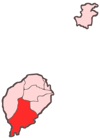 Location within São Tomé and Príncipe | |
| Coordinates: 0°5′N 6°35′E / 0.083°N 6.583°ECoordinates: 0°5′N 6°35′E / 0.083°N 6.583°E | |
| Country | São Tomé and Príncipe |
| Province/Island | São Tomé |
| Seat | São João dos Angolares |
| Area | |
| • Total | 267 km2 (103 sq mi) |
| Population (2008) | |
| • Total | 6,857 |
| • Density | 26/km2 (67/sq mi) |
| Time zone | UTC+0 (UTC) |
Caué is a district of São Tomé Province. Out of the seven districts that make up the equatorial Atlantic islands of São Tomé and Príncipe, it is one of the smallest in terms of population, but is the largest in area covering approximately 267 square kilometers. Its population is 6,857 (2012)[1] – the highest population in 70 years. The district capital is São João dos Angolares. The municipality includes the small islet of Rolas where the equator passes right though the islet's only settlement and has an equatorial monument there, much of the islet is south of the equator and being in the Southern Hemisphere.
The district are divided into two subdistricts or municipalities: São João dos Angolares and Malanza.
Population
- 1940 6,675 (11.0% of the national population)
- 1950 6,942 (11.6% of the national population)
- 1960 5,874 (9.1% of the national population)
- 1970 3,757 (5.1% of the national population)
- 1981 4,607 (4.8% of the national population)
- 1991 5,322 (4.5% of the national population)
- 2001 5,501 (4.0% of the national population)[1]
- 2008 6,270 (est.)[1]
- 2012: 6,867[1]
Settlements
The main settlement is the town São João dos Angolares. Other settlements are:
- Angra Toldo
- Dona Augusta
- Vila Clotilde
- Ilhéu das Rolas one of several world settlements (currently having a permanent population) that has the equator passing through it and the only part that has area in the southern hemisphere
- Vila Malanza
- Monte Mário
- Ponta Baleia
- Praia Pesqueira
- Pesqueira
- Porto Alegre
- Ribeira Peixe
- Santa Josefina
Hamlets
- Vila Aida
- Vila Irene
- Novo Brasil
- Praia Grande
Geography
Other than Ilhéu das Rolas, the district also includes other islet features including Ilhéu Quixibá and Sete Pedras.
The district has always been completely forested. Agricultural plantations and built up areas also dominates the district. Formerly founded throughout the island, wildlife are still founded in many parts of the district including the southern and the western parts. Many parts of the district, the middle and the west of the island forms a part of Obo Natural Park,[2] the most notable natural landmark is the volcanic vent Pico Cão Grande.
Economy
50% of the district lied below the poverty line.
Its main industry is agriculture in the district and features several agricultural companies.[3]
Language
Portuguese is the official language of the nation, unlike other parts of the island, the majority of the primary spoken language is Angolar.
Politics
Caué currently has five seats in the National Assembly.[4]
References
- 1 2 3 4 INE, Evolução da população São-Tomense por localidades, 2001/2012
- ↑ "Tourist Attractions". Sao Tome and Principe Travel and Tourism. Retrieved 15 November 2011.
- ↑ Silva, C.F.L.L. - Segurança alimentar em São Tomé e Príncipe. Estudo de caso dos distritos de Água-Grande e Mé-Zóchi. Lisbon: ISA, 2014, p. 160
- ↑ Elections in São Tomé and Principe, African Elections Database.
Places adjacent to Caué District | ||||||||||
|---|---|---|---|---|---|---|---|---|---|---|
| ||||||||||
| Communities | | |
|---|---|---|
| Geographical features | ||
| Landmarks and hotels | ||
| Culture | ||