Coglians
| Coglians - Hohe Warte | |
|---|---|
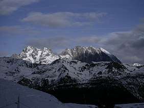 Monte Coglians (first high peak from the left) seen from Mt. Zoncolan (south) | |
| Highest point | |
| Elevation | 2,780 m (9,120 ft) |
| Prominence | 1,144 m (3,753 ft) [1] |
| Isolation | 33.7 kilometres (20.9 mi) |
| Coordinates | 46°36′25″N 12°53′17″E / 46.60694°N 12.88806°ECoordinates: 46°36′25″N 12°53′17″E / 46.60694°N 12.88806°E |
| Geography | |
 Coglians - Hohe Warte Location in the Alps | |
| Location |
Friuli-Venezia Giulia, Italy Carinthia, Austria |
| Parent range | Carnic Alps |
| Climbing | |
| First ascent | 30 September 1865 by Paul Grohmann from the South |
| Easiest route | Hike |
Monte Coglians (Friulian: Coliàns; German: Hohe Warte) is the highest mountain of the Carnic Alps, on the border between Italy (province of Udine) and Austria (Carinthia), west of the Monte Croce Carnico pass (Plöcken Pass). With its elevation of 2,780 m (9,121 ft), it is the highest peak of the Friuli-Venezia Giulia region of Italy and of the Carnic and Gailtal Alps.
Monte Coglians is characterised by karst topography.
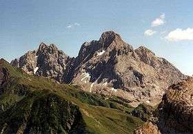
Coglians (right) as seen from the NW
References
- ↑ "Monte Coglians - Peakbagger". peakbagger.com. Retrieved 1 February 2015.
Related articles
External links
- Monte Coglians on Hribi.net (includes a 360° panoramic view from Monte Coglians)
- "Monte Coglians, Austria/Italy". Peakbagger.com.
This article is issued from
Wikipedia.
The text is licensed under Creative Commons - Attribution - Sharealike.
Additional terms may apply for the media files.