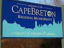
Cape Breton Regional Municipality
| Cape Breton Regional Municipality (CBRM) | |||
|---|---|---|---|
| Regional Municipality | |||
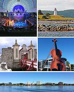 Montage of CBRM sites, clockwise from top left - Highland Arts Theatre, Gabarus Light House, Big Fiddle, Sydney Waterfront, Gate at Fortress of Louisbourg. | |||
| |||
| Nickname(s): A Community of Communities | |||
|
Motto(s): Fortuna Non Mutat Genus (Circumstances Do Not Change Our Origin) | |||
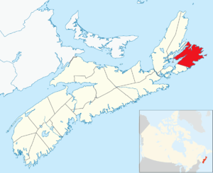 Location of Cape Breton Regional Municipality | |||
| Coordinates: 46°08′20″N 60°11′35″W / 46.13889°N 60.19306°WCoordinates: 46°08′20″N 60°11′35″W / 46.13889°N 60.19306°W | |||
| Country | Canada | ||
| Province | Nova Scotia | ||
| County | Cape Breton | ||
| First Nations | Eskasoni First Nation, Membertou First Nation | ||
| Established | August 1, 1995 | ||
| Electoral Districts Federal |
Cape Breton—Canso / Sydney—Victoria | ||
| Provincial | Cape Breton Centre / Cape Breton-Richmond / Glace Bay / Northside-Westmount / Sydney River-Mira-Louisbourg / Sydney-Whitney Pier / Victoria-The Lakes | ||
| Government | |||
| • Type | Cape Breton Regional Council | ||
| • Mayor | Cecil Clarke | ||
| • MPs | Rodger Cuzner, Mark Eyking | ||
| • MLAs | Tammy Martin, Alana Paon, Geoff MacLellan, Eddie Orrell, Alfie MacLeod, Derek Mombourquette, Keith Bain | ||
| Area (2016)[1] | |||
| • Land | 2,430.06 km2 (938.25 sq mi) | ||
| Elevation | Sea Level to 235 m (0 to 771 ft) | ||
| Population (2016)[1] | |||
| • Total | 94,285 | ||
| • Density | 38.8/km2 (100/sq mi) | ||
| • Change 2011-16 |
| ||
| • Census ranking | 58 of 5,162 | ||
| Demonym(s) | Cape Bretoner | ||
| Time zone | UTC−4 (AST) | ||
| • Summer (DST) | UTC−3 (ADT) | ||
| Postal code | B1x, B2x | ||
| Area code(s) | 902 | ||
| Dwellings | 45,342 | ||
| Median Income* | $41,257 CDN | ||
| Coastline |
Atlantic 800 km (500 mi) Bras d'Or Lakes 400 km (250 mi) | ||
| Roadways | 1,600 km (1,000 mi) | ||
| NTS Map | 011K01 | ||
| GNBC Code | CBUCD | ||
| Website | cbrm.ns.ca | ||
| |||

Cape Breton Regional Municipality, often referred to as simply CBRM, is the Canadian province of Nova Scotia's second largest municipality and the economic heart of Cape Breton Island.[2] As of 2016 the municipality has a population of 94,285. The municipality was created in 1995 through the amalgamation of eight municipalities located in Cape Breton County.
The region is home to a significant concentration of government services, social enterprise and private sector companies, including the Canadian Coast Guard College, Cape Breton University, NSCC Marconi campus, and New Dawn Enterprises. The rural areas of the municipality continue to host resource industries such as agriculture, fishing, mining, and forestry. CBRM is host to many cultural landmarks and institutions such as the Celtic Colours International Festival, the Cape Breton Centre for Craft, the Highland Arts Theatre, and Holy Angels Arts & Cultural centre, currently undergoing a $12 million renovation.[3]
The area hosts one of Nova Scotia's premier tourism destinations, the Fortress of Louisbourg national park site, operated by Parks Canada as a living history museum. The site stands as the largest reconstruction project in North America.[4] The Port of Sydney was projected to welcome a record 135,000 cruise ship visitors in 2017, a 67% increase on 2016.[5] The Trans-Canada Highway terminates in North Sydney where Marine Atlantic ferries connect to both Channel-Port aux Basques Newfoundland, where the highway starts again, as well as Argentia Newfoundland.[6]
History
Early history
The glaciers began their retreat from the Maritimes approximately 13,500 years ago,[7] with final deglaciation, post-glacial rebound, and sea level fluctuation ending and leaving the New England-Maritimes region virtually ice free 11,000 years ago.[8][7] The earliest evidence of Paleo-Indian settlement in the region follows rapidly after deglaciation. Evidence of settlement found in the Debert Palaeo-Indian Site dates to 10,600 before present, though settlement seems likely to have occurred earlier,[8] following large game animals such as the caribou as they expanded into the land revealed by the retreating glaciers. The record of continuous habitation through the paleo and archaic period over ten thousand years culminated in the development of the culture, traditions, and language of the First Nations people now known as the Mi'kmaq.[9]
Mi'kmaq
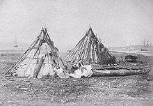
For several thousand years the area now known as Cape Breton Island has been a part of the territory of the Mi'kmaq nation of Mi'kma'ki. Mi'kma'ki includes what is now the Maritimes, parts of Maine, Newfoundland and the Gaspé Peninsula. Cape Breton Regional Municipality is located in the Mi'kmaw district of Unama'kik.
French settlement
The French were the first Europeans to claim the region, which was named Acadia. Control passed back and forth between the English and French throughout the late 17th and early 18th centuries. Under the Treaty of Utrecht of 1713, France retained control of "Île Royale". In 1719, France began construction on a fortified town located along the sheltered southwestern shore of Havre Louisbourg, naming the settlement Louisbourg.
The fortress was captured by British colonial forces, then returned by the British to France. It was captured again during the Seven Years' War which saw the inhabitants expelled and the fortress completely destroyed by British Army engineers in 1760.
Post-Acadian settlement
By proclamation of October 17, 1763, after termination of the Seven Years' War, Île Royale was renamed Cape Breton Island and was formally annexed to Nova Scotia. For a time thereafter Cape Breton Island was part of Halifax County. On December 10, 1765, Cape Breton Island was set apart as a separate county. In 1784, the island was made a separate colony with its capital at Sydney however by 1820 the colony was remerged into Nova Scotia.
Industrial activity
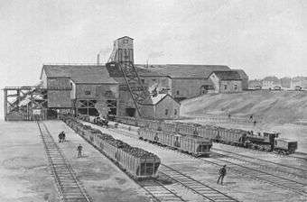
Coal mining began during the 18th century to supply Fortress Louisbourg. Industrial mining began in 1826 under the General Mining Association monopoly, followed in later years by independent American-owned mines south of Sydney Harbour. Large-scale mining commenced in 1893 under the auspices of the Dominion Coal Company (DOMCO) which merged these independent mines. Coal production under Dominion Steel and Coal Corporation (DOSCO) peaked in the early 1940s and in 1957 the company became a subsidiary of Hawker-Siddley Group. The company announced in 1965 that it would be exiting the coal mining business within months.
In response to a public outcry, the minority government of Prime Minister Lester B. Pearson announced J.R. Donald would head a Royal Commission of Inquiry into the Cape Breton coal industry, with hearings held in 1965 and 1966. The Donald Commission recommended that a federal Crown corporation be established to acquire and manage DOSCO's coal operations, with the aim being to slowly wean the area economy from its dependence on the coal industry.
On July 7, 1967, the Cape Breton Development Corporation (DEVCO), was established to operate the mines in the interim, while phasing them out throughout the 1970s and, at the same time, develop new economic opportunities for the surrounding communities. At the same time, the provincial government expropriated DOSCO's steel mill in Sydney, creating the Sydney Steel Corporation (SYSCO), while DEVCO would continue to operate the adjacent coke ovens. By 1992 the Lingan Colliery was closed followed by the Phalen Colliery in 1999 and the Prince Colliery in 2001. At the same time, the provincial government decided to dismantle and sell SYSCO.
DEVCO ceased to exist on December 31, 2009, with its remaining assets and staff turned over to Enterprise Cape Breton Corporation (ECBC), a federal government economic development initiative, in an attempt to diversify the CBRM economy.[10] On June 19, 2014, the operations of ECBC were transferred to both the Atlantic Canada Opportunities Agency and the Public Works and Government Services Canada.[11]
Amalgamation
In 1992 the Task Force on Local Government Report (often called the Hayward report) stated that 67 municipalities in Nova Scotia were too many to efficiently and cost effectively provide services in a province having a population of slightly more than 900,000.[12] The report was commissioned for the Progressive Conservative government of Donald Cameron, but was taken up and implemented by the incoming Liberal government of John Savage.
The provincial government subsequently forced the amalgamation of both Halifax and Cape Breton counties and supported the voluntary amalgamation of Queens county. The Cape Breton Regional Municipality Act was implemented and the CBRM was created on August 1, 1995, whereas the amalgamation in Halifax County didn't take place until April 1, 1996, and Queens County several years later.
The municipalities from which the CBRM was created included the Municipality of the County of Cape Breton, the City of Sydney, the Towns of Glace Bay, Sydney Mines, New Waterford, North Sydney, Dominion and Louisbourg.
Government
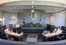
The Cape Breton Regional Municipality is governed by Cape Breton Regional Council, which is composed of a mayor elected at-large and 12 councillors each elected to represent a separate district. Regional Council is responsible for all facets of the municipal government, including police, fire, library, transit, and water. The municipality oversaw an operating budget of $146 million and a combined capital and water capital budget of $32.375 million in the 2016/17 fiscal year.[13] The current mayor is Cecil Clarke. Council and its committees meet at least once a month.
Municipal governments in Nova Scotia are elected every four years and the most recent round of elections took place on October 15, 2016. The provincial legislation that creates and empowers the municipality is the Nova Scotia Municipal Government Act.[14] Under former Mayor John Morgan, the council authorized several studies regarding fairness and equity, fighting for a larger share of the federal equalization funding from the province, including an ultimately unsuccessful legal challenge in 2004.[15] Nova Scotians for Equalization Fairness is a citizens group that continues to argue for a greater share of equalization payments paid to CBRM, arguing that CBRM receives $15 million in equalization and should receive $239 million, based on per capita distribution of federal equalization to the province.[16]
In addition to municipal government there are two First Nations in CBRM operating under band government, the Eskasoni First Nation and the Membertou First Nation.[17] CBRM is represented by seven ridings in the Nova Scotia House of Assembly. The municipality shares representation by two ridings in Canada's House of Commons, as well as by Senator Michael L. MacDonald, who identifies as representing the Senate Division of Cape Breton.
Economy
After a long struggle to recover from the disappearance of coal and steel industries, the Cape Breton economy is still suffering from high annual population loss. Cape Breton Island, of which CBRM is home to over three quarters of the population, has continued economic strength in its fishing and forestry primary sectors and in services (trade, transportation and warehousing, business and other support services), education, health care, and accommodation & food.[18] While the region boasts a diverse industrial economy when compared to other regions in Nova Scotia,[19] the region continues to struggle with an unemployment rate of 13.7% in December 2017, significantly higher than the Nova Scotia and national averages.[20]
CBRM is home to a significant tourism industry and has benefited greatly from Cape Breton Island having been named the 2016 number one island to visit in North America by 'Travel + Leisure', an industry magazine targeting tourist trade by industry insiders.[21] Nearby attractions such as the Cape Breton Highlands, Bras d'Or Lake and Fortress of Louisbourg have made Cape Breton Island a tourism destination for many years. Visitors can experience the art and history that Sydney and area has to offer,[22] or experience Sydney's surging culinary scene.[23][24] A growing cruise ship business has been making use of the port of Sydney to give cruise passengers access to the area. The Port of Sydney hosts more than 70 cruise ships per season,[25] most notably the Queen Mary 2, Queen Elizabeth 2, and MS Maasdam. A recent study found that a strong tourism cluster is emerging and will be reinforced with the recent announcement of a second cruise ship dock in Sydney.[26]
Currently, the former Sydney Steel Corporation's site in Sydney has been transformed into the Harbourside Commercial Park focused on office and light industrial use, connected in 2010 by the Sydney Port Access Road to Highway 125.[27] As the province's second largest municipality, recent federal policy of increased infrastructure spending will provide added economic stimulus.[18]
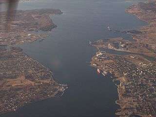
Geography
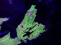
The boundary of CBRM includes all of Cape Breton County except for the Eskasoni and Membertou First Nations.
Land area of the municipality is 2,433.35 square kilometres with a population density (2011) of just 40.0 persons per square kilometre. This compares to the provincial land area of 52,940 square kilometres and population density of 17.4 persons per square kilometre.[28]
Climate
The climate of the CBRM is cool and wet although it is warmer than most other places in Canada. The average annual temperature is close to 6 degrees Celsius (43°F). The average summer maximum temperature is 25 degrees Celsius (77 °F).
Temperatures rarely rise above 30 °C (86 °F). The average winter low is −10 degrees Celsius (14 °F) and temperatures rarely drop below −20 degrees Celsius (−4 °F) although strong winter winds can make it seem much colder.
| Climate data for Sydney Airport, 1981–2010 normals, extremes 1870–present[29] and from April 1941 to the present day at Sydney Airport.[30][30] | |||||||||||||
|---|---|---|---|---|---|---|---|---|---|---|---|---|---|
| Month | Jan | Feb | Mar | Apr | May | Jun | Jul | Aug | Sep | Oct | Nov | Dec | Year |
| Record high humidex | 18.2 | 19.0 | 25.0 | 26.0 | 36.8 | 43.4 | 41.8 | 41.9 | 38.9 | 30.4 | 25.5 | 18.5 | 43.4 |
| Record high °C (°F) | 16.9 (62.4) |
18.0 (64.4) |
24.0 (75.2) |
27.2 (81) |
31.1 (88) |
34.4 (93.9) |
33.9 (93) |
36.7 (98.1) |
32.3 (90.1) |
27.2 (81) |
22.2 (72) |
16.7 (62.1) |
36.7 (98.1) |
| Average high °C (°F) | −1.1 (30) |
−1.5 (29.3) |
1.5 (34.7) |
6.6 (43.9) |
13.1 (55.6) |
18.6 (65.5) |
23.1 (73.6) |
22.9 (73.2) |
18.8 (65.8) |
12.6 (54.7) |
7.3 (45.1) |
2.1 (35.8) |
10.3 (50.5) |
| Daily mean °C (°F) | −5.4 (22.3) |
−5.9 (21.4) |
−2.6 (27.3) |
2.5 (36.5) |
7.9 (46.2) |
13.2 (55.8) |
17.9 (64.2) |
18.0 (64.4) |
14.0 (57.2) |
8.5 (47.3) |
3.8 (38.8) |
−1.5 (29.3) |
5.9 (42.6) |
| Average low °C (°F) | −9.6 (14.7) |
−10.3 (13.5) |
−6.7 (19.9) |
−1.6 (29.1) |
2.7 (36.9) |
7.7 (45.9) |
12.6 (54.7) |
13.1 (55.6) |
9.1 (48.4) |
4.3 (39.7) |
0.2 (32.4) |
−5 (23) |
1.4 (34.5) |
| Record low °C (°F) | −31.7 (−25.1) |
−31.7 (−25.1) |
−31.1 (−24) |
−17.8 (0) |
−7.8 (18) |
−3.9 (25) |
0.6 (33.1) |
2.2 (36) |
−2.2 (28) |
−5.6 (21.9) |
−13.9 (7) |
−23.3 (−9.9) |
−31.7 (−25.1) |
| Record low wind chill | −42.6 | −41.1 | −34.3 | −21.4 | −11.3 | −6.1 | 0.0 | 0.0 | −5.1 | −10.5 | −19.3 | −31.3 | −42.6 |
| Average precipitation mm (inches) | 152.5 (6.004) |
128.1 (5.043) |
130.0 (5.118) |
133.3 (5.248) |
103.2 (4.063) |
96.9 (3.815) |
88.5 (3.484) |
100.2 (3.945) |
118.7 (4.673) |
142.9 (5.626) |
156.0 (6.142) |
167.0 (6.575) |
1,517.2 (59.732) |
| Average rainfall mm (inches) | 80.5 (3.169) |
63.8 (2.512) |
83.2 (3.276) |
112.2 (4.417) |
100.9 (3.972) |
96.9 (3.815) |
88.5 (3.484) |
100.2 (3.945) |
118.7 (4.673) |
142.2 (5.598) |
144.0 (5.669) |
111.2 (4.378) |
1,242.4 (48.913) |
| Average snowfall cm (inches) | 74.3 (29.25) |
65.3 (25.71) |
48.1 (18.94) |
21.4 (8.43) |
2.3 (0.91) |
0.0 (0) |
0.0 (0) |
0.0 (0) |
0.0 (0) |
0.62 (0.244) |
12.4 (4.88) |
58.5 (23.03) |
283.0 (111.42) |
| Average precipitation days (≥ 0.2 mm) | 20.6 | 16.5 | 16.6 | 15.8 | 14.5 | 14.0 | 11.7 | 12.7 | 13.5 | 15.9 | 18.1 | 21.0 | 191.0 |
| Average rainy days (≥ 0.2 mm) | 8.4 | 7.3 | 9.5 | 13.0 | 14.1 | 14.0 | 11.7 | 12.7 | 13.5 | 15.8 | 15.4 | 11.5 | 146.9 |
| Average snowy days (≥ 0.2 cm) | 16.6 | 12.6 | 11.0 | 5.6 | 0.83 | 0.0 | 0.0 | 0.0 | 0.0 | 0.62 | 5.4 | 14.2 | 66.8 |
| Average relative humidity (%) (at 15:00 LST) | 72.5 | 72.0 | 69.8 | 69.7 | 65.0 | 64.9 | 65.2 | 65.2 | 67.6 | 70.5 | 74.2 | 75.9 | 69.2 |
| Mean monthly sunshine hours | 91.0 | 111.6 | 132.9 | 141.0 | 198.0 | 224.6 | 246.9 | 228.4 | 167.1 | 130.1 | 77.0 | 68.2 | 1,816.7 |
| Percent possible sunshine | 32.4 | 38.3 | 36.1 | 34.7 | 42.7 | 47.7 | 51.8 | 52.0 | 44.3 | 38.3 | 27.1 | 25.3 | 39.2 |
| Source: Environment Canada[31][29][32][33][34][35] | |||||||||||||
Demographics
| Historical population | ||
|---|---|---|
| Year | Pop. | ±% |
| 1851 | 27,520 | — |
| 1861 | 20,866 | −24.2% |
| 1871 | 26,454 | +26.8% |
| 1881 | 31,817 | +20.3% |
| 1891 | 34,244 | +7.6% |
| 1901 | 49,166 | +43.6% |
| 1911 | 73,330 | +49.1% |
| 1921 | 86,319 | +17.7% |
| 1931 | 92,502 | +7.2% |
| 1941 | 110,703 | +19.7% |
| 1951 | 120,306 | +8.7% |
| 1956 | 125,478 | +4.3% |
| 1961 | 131,507 | +4.8% |
| 1971 | 129,075 | −1.8% |
| 1981 | 127,035 | −1.6% |
| 1986 | 123,625 | −2.7% |
| 1991 | 117,403 | −5.0% |
| 1996 | 114,733 | −2.3% |
| 2001 | 105,968 | −7.6% |
| 2006 | 102,250 | −3.5% |
| 2011 | 97,398 | −4.7% |
| 2016 | 94,285 | −3.2% |
| [36][37] Population prior to 1996 is for Cape Breton County. Population from 1996 onwards is for Cape Breton Regional Municipality, which has the same boundaries as the former county. | ||
In the 2016 Census of Population conducted by Statistics Canada, the Cape Breton Regional Municipality recorded a population of 94,285 living in 41,679 of its 45,742 total private dwellings, a change of −3.2% from its 2011 population of 97,398. With a land area of 2,430.06 km2 (938.25 sq mi), it had a population density of 38.8/km2 (100.5/sq mi) in 2016.[1]
The following is a list of responses finding greater than 1,000 residents:
| Ethnicity | Population | Percent |
|---|---|---|
| Canadian | 49,960 | 46.3% |
| Scottish | 43,055 | 39.9% |
| English | 24,305 | 22.5% |
| Irish | 23,300 | 21.6% |
| French | 17,665 | 16.4% |
| North American Indian | 4,435 | 4.1% |
| Italian | 3,075 | 2.9% |
| German | 2,660 | 2.5% |
| Polish | 2,390 | 2.2% |
| Dutch (Netherlands) | 1,520 | 1.4% |
| Ukrainian | 1,140 | 1.1% |
| Welsh | 1,105 | 1.0% |
| Lebanese | 1,075 | 1.0% |
Most of Cape Breton residents identify as Christian (90.5%). About 8.5% affiliates with no religion and the remaining 1.0% affiliate with another religion.
Mother tongue language (2011)[39]
| Language | Population | Pct (%) |
|---|---|---|
| English only | 93,210 | 97.21% |
| French only | 920 | 0.96% |
| Non-official languages | 1,475 | 1.54% |
| Multiple responses | 270 | 0.28% |
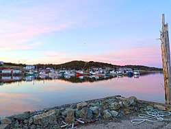
Transportation
.jpg)
The Port of Sydney Development Corporation was established in 2015. Owned by the municipality, the port corporation manages and operates the port, including the emerging cruise ship business, the Joan Harriss Cruise Pavilion and Marina.[40] International investors have announced construction of the Novaporte, the deep-water marine container facility able to accommodate ultra-class container ships at the port. Novaporte is proposed to operate as an officially designated Canadian Foreign Trade Zone.[41] The Port of Sydney was projected to welcome a record 135,000 cruise ship visitors in 2017, a 67% increase on 2016.[5]
J.A. Douglas McCurdy Sydney Airport serves CBRM and Cape Breton Island, providing domestic flight connections via Air Canada and WestJet as well as charter flight service. The airport is classified as an airport of entry, staffed by the Canada Border Services Agency. The region is served by Maritime Bus, a coach bus service connecting North Sydney and Sydney to the mainland via Whycocomagh and Wagmatcook. The Cape Breton and Central Nova Scotia Railway provided rail service connecting Cape Breton to the mainland and CN Rail in Truro. Service ended December 30, 2014 though negotiations between the province and the owner to revive the railway are ongoing. Sydney Coal Railway is a short line railway connecting the coaling piers on Sydney Harbour in Sydney to the Lingan Generating Station near New Waterford.

The municipality is the western terminus of the Marine Atlantic ferry services to Newfoundland. It is also the eastern terminus of two east-west highways in the province: Highway 105, the Trans-Canada Highway, runs along the north shore of Bras d'Or Lake and accesses the northern part of CBRM, whereas Trunk 4 extends along the southern part of Bras d'Or Lake and accesses the western and eastern part of the municipality. Within the municipality communities are served by Highway 125, a regional 4-lane arterial limited access highway that circles Sydney Harbour.
Public transit service is delivered by Transit Cape Breton, which offers thirteen bus routes within the municipality, serving the region's larger communities: Sydney, Sydney River, Glace Bay, New Waterford, Dominion, Reserve Mines, North Sydney and Sydney Mines. Handi-Trans paratransit is available for passengers whose disabilities restrict them from using Transit Cape Breton's regular bus service. Fares range from $1.25 to $5, depending on how many zones are travelled.[42]
Education
The regional municipality is home to several institutions of higher learning:
English language public schools in CBRM are operated by the Cape Breton – Victoria Regional Centre for Education on behalf of the provincial government's Department of Education. This regional education office provides instruction for grades primary to 12 in CBRM as well as in neighbouring Victoria County.
French language public school education is administered throughout the province by the Conseil Scolaire Acadien Provincial.
Culture
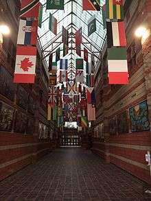
While Cape Breton Island is arguably best known for its Scottish Gaelic or Celtic culture and heritage, the industrial strength of Sydney and industrial Cape Breton attracted a diverse community from around the world. CBRM's cultural scene continues to be influenced by a mixture of these other cultures including African Canadian, Jewish, Irish, and a variety of Eastern European countries.[43]

The region is home to several festivals of art and music such as the Celtic Colours International Festival, Lumiere Art at Night, and the Cape Breton International Drum Festival. The area is also well known for its music scene. Perhaps the most famous musician from CBRM was Canadian country singer Rita MacNeil from the CBRM community of Big Pond, and known for her songs including her biggest hits "Flying On Your Own" and "Working Man."[44]
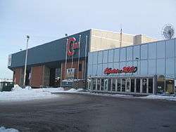
CBRM is home to several performance centres, including the Centre 200 sports arena in Sydney, home to the Cape Breton Screaming Eagles (a Quebec Major Junior Hockey League team), the Highland Arts Theatre performing arts centre, also in Sydney, and the historic Savoy Theatre, in Glace Bay. The Holy Angels Arts & Cultural centre is currently undergoing a $12 million renovation.[3] Glace Bay is also home to the Cape Breton Miners' Museum, the Marconi National Historic Site and the Glace Bay Heritage Museum. Louisbourg is home to Fortress of Louisbourg, the largest historical reconstruction in North America.
CBRM is home to several media outlets. CBC Radio broadcasts local morning and afternoon broadcasts across Cape Breton Island. There are also five commercial radio stations. Cape Breton's daily newspaper the Cape Breton Post is a broadsheet focusing on Cape Breton Island. Its editorial style is populist conservative, and it is owned by The Chronicle Herald.
Protective services
Police
The Cape Breton Regional Police Service provides policing for all areas of CBRM with the exception of the First Nation community of Eskasoni which is policed by the Royal Canadian Mounted Police (RCMP). The CBRPS operates out of three geographic divisions, Central (Sydney), East (Glace Bay) and North (North Sydney). The CBRPS works towards providing efficient law enforcement and working within the community and has recently cracked down on drug related crime in CBRM. The Chief of Police is Peter J. McIsaac.[45]
Policing in Cape Breton County prior to amalgamation was delivered by individual police forces in the urban areas and RCMP in the rural county. In the late 1990s, after a divisive debate, the municipality expanded CBRPS coverage to also cover the rural area of CBRM.
Fire & Emergency
Fire & emergency services for the CBRM are provided by the Cape Breton Regional Fire Service which consists of 36 fire stations dispersed throughout the municipality; two urban stations are staffed by career firefighters whereas the remaining 34 rural stations are staffed by volunteers. CBRFE has divisions for administration, fire departments, training, fire prevention, volunteer coordination, hazardous materials, building services and bylaws.[46] In addition, paramedic ambulance service in Nova Scotia is provided by the provincial government's Emergency Health Services.
Emergency Measures Organization
The provincial Emergency Measures Act requires each municipality to develop an emergency measures organization. The municipality has an Emergency Measures Coordinator supported by an EMO Advisory Committee and an Emergency Preparedness Planning Committee.
Neighbourhoods and communities
Unincorporated cities and towns
Communities
- Albert Bridge
- Alder Point
- Barachois Harbour
- Beaver Cove
- Benacadie
- Ben Eoin
- Big Beach
- Big Pond
- Birch Grove
- Boisdale
- Bras d'Or
- Broughton
- Catalone
- Catalone Gut
- Christmas Island
- Coxheath
- Dalem Lake
- Donkin
- East Bay
- Enon
- Florence
- Gabarus
- Gabarus Lake
- Gardiner Mines
- Georges River
- Grand Lake Road
- Grand Narrows
- Hillside
- Hillside Boularderie
- Homeville
- Hornes Road
- Howie Centre
- Leitches Creek
- Leitches Creek Station
- Lingan
- Lingan Road
- Little Bras d'Or
- Main-à-Dieu
- Marion Bridge
- Middle Cape
- Mira Road
- New Victoria
- Northside East Bay
- Point Aconi
- Port Morien
- Reserve Mines
- Round Island
- Salem Road
- Salmon River Road
- Shunacadie
- Scotchtown
- South Bar
- Sydney
- Sydney Forks
- Sydney River
- Trout Brook
- Upper Leitches Creek
- Victoria Bridge
- Victoria Mines
- Westmount
Sister cities

- Wałbrzych, Poland: On June 26, 2018, the Council of the Cape Breton Regional Municipality passed a resolution to recognize Wałbrzych as a partner city. This followed a resolution in Wałbrzych on June 21, 2018. The CBRM resolution cited commonalities in post-industrial heritage, and potential future collaboration among historic sites, schools, universities and businesses. Also noted was the Cape Breton Regional Municipality's longstanding Polish community.[48][49]
Access routes
Highways and numbered routes that run through the county, including external routes that start or finish at the county limits:[50]
Notable people
- Tracy Dares, pianist
See also
References
- 1 2 3 "Population and dwelling counts, for Canada, provinces and territories, and census subdivisions (municipalities), 2016 and 2011 censuses – 100% data (Nova Scotia)". Statistics Canada. February 8, 2017. Retrieved February 12, 2017.
- ↑ http://sydneyareachamber.ca/our-community/
- 1 2 Conners, Holy Jean (2017-04-12). "Former Sydney convent to become $12M arts and culture centre". CBC.
- ↑ National Geographic Guide to the National Parks of Canada, 2nd Edition. National Geographic Society. 2016. p. 49. ISBN 978-1-4262-1756-2.
- 1 2 MacPhee, Norma Jean (2017-03-17). "Port of Sydney ready to welcome record 135,000 cruise ship visitors". CBC.
- ↑ "Marine Atlantic"
- 1 2 Stea, Robert (1998). "Deglaciation of Nova Scotia: Stratigraphy and chronology of lake sediment cores and buried organic sections" (PDF). erudit. Géographie physique et Quaternaire. Retrieved 30 March 2018.
- 1 2 Lothrop, Jonathon. "Early Human Settlement of Northeastern North America". Taylor and Francis. Paleo America. Retrieved 30 March 2018.
- ↑ "A Mi'kmaw History". Parks Canada. Parks canada. Archived from the original on 2018-03-31. Retrieved 30 March 2018.
- ↑ Ayers, Tom (2009-10-19). "Devco ready to dissolve". Cape Breton Post. Sydney, Nova Scotia. Archived from the original on 2012-01-01. Retrieved 2010-10-14.
- ↑ "ECBC Archived Content". 2014-06-19. Retrieved 2018-02-27.
- ↑ "1992 Task Force on Local Government Report" (PDF). April 1992. Retrieved 2018-02-27.
- ↑ King, Nancy (12 May 2016). "CBRM approves 'getting-by budget'". Cape Breton Post. Retrieved 26 Feb 2018.
- ↑ https://nslegislature.ca/sites/default/files/legc/statutes/municipal%20government.pdf "Municipal Government Act"
- ↑ Shannon, Chris (19 Oct 2012). "John Morgan leaves behind mixed legacy from years as mayor". Cape Breton Post. Retrieved 26 Feb 2018.
- ↑ "Nova Scotian's for Equalization Fairness Meeting Tuesday". Cape Breton Post. 6 March 2018.
- ↑ "Mi'kmaw Bands in Nova Scotia". Cape Breton University. Retrieved August 21, 2017.
- 1 2 "Nova Scotia's Economic Regions - Macro Outlook 2017 – 2021". Canmac Economics Ltd. May 2017.
- ↑ "Canmac Economics, Statistics Canada Labour Force Historical Review". Canmac Economics Ltd. 2010. Missing or empty
|url=(help) - ↑ "Cape Breton's unemployment rate increases slightly". Cape Breton Post. 2017-01-05.
- ↑ Henheffer, Tom (2016-03-29). "The Third Best Island In the World". Macleans Ltd.
- ↑ Hunter, James (2016). "14 Fun Things You Have To Do On Your Next Road Trip To Sydney". Narcity.
- ↑ Donaldson, Cathy (2017-11-03). "Returning as a 'tourist' to hometown of Sydney". Chronicle Herald.
- ↑ Wesley, Gillian (2017-05-16). "Your No-Fail Cape Breton Vacation Guide". the Local Traveller.
- ↑ Shannon, Chris (2016-01-13). "Cruise ships calling". Cape Breton post.
- ↑ "Nova Scotia's Economic Regions - Macro Outlook 2017 – 2021". Canmac Economics Ltd. May 2017.
- ↑ "Summer 2010 - Completion of Ferry Street - Spar Road Interconnection". Harbourside Commercial Park.
- ↑ "Focus on Geography Series, 2011 Census - Census subdivision of Cape Breton, RGM - Nova Scotia"
- 1 2 "Sydney". Canadian Climate Data. Environment Canada. Retrieved 8 April 2016.
- 1 2 "Sydney A". Canadian Climate Data. Environment Canada. Retrieved 8 April 2016.
- ↑ "Sydney A Normals". Canadian Climate Normals 1981–2010. Environment Canada. Retrieved 7 April 2016.
- ↑
- ↑
- ↑
- ↑ "March 2012". Canadian Climate Data. Environment Canada. Retrieved 7 April 2016.
- ↑ 137.pdf Archived March 4, 2016, at the Wayback Machine., Canada Year Book 1952-53
- ↑ 123.pdf Archived March 4, 2016, at the Wayback Machine., Canada Year Book 1957-58
- ↑ Statistics Canada (2007-03-13). Cape Breton, Nova Scotia (Code1217030) (table). 2006 Community Profile (2006 Census ed.). Ottawa: Statistics Canada Catalogue no. 92-591-XWE. Archived from the original on 2012-01-01. Retrieved 2012-01-01.
- ↑ Statistics Canada: 2011 census
- ↑ "Business Development About the Port". Port of Sydney. Retrieved 2017-03-01.
- ↑ "Ports America and Sydney Harbour Investment Partners Agreement on Marine Container Facility in Port of Sydney, Nova Scotia". Atship Services Ltd. 2016-12-12.
- ↑ Transit Cape Breton Riders' Guide (PDF) (Map) (October 2007 ed.). Cape Breton Regional Municipality. Retrieved 2008-08-08.
- ↑ "Diversity Cape Breton". Retrieved 2018-03-01.
- ↑ Roberts, David (2006). British Hit Singles & Albums (19th ed.). London: Guinness World Records Limited. p. 341. ISBN 1-904994-10-5.
- ↑ https://www.cbrps.ca/chiefs-message.html "CBRP Chief's Message"
- ↑ "Fire - Cape Breton Regional Municipality"
- ↑ Jala (2015).
- ↑ http://www.cbrm.ns.ca/cbrm-meetings-and-minutes.html
- ↑ Paweł Gołębiowski, "Wałbrzych nawiąże stosunki partnerskie z regionem Cape Breton w Kanadzie" http://walbrzych.naszemiasto.pl/artykul/walbrzych-nawiaze-stosunki-partnerskie-z-regionem-cape,4697961,art,t,id,tm.html
- ↑ Atlantic Canada Back Road Atlas ISBN 978-1-55368-618-7 Pages 42-43, 58-59
External links
| Wikimedia Commons has media related to Cape Breton Regional Municipality. |
- Cape Breton Regional Municipality - Official Website
- Cape Breton Regional Police Services
- Photographs of historic monuments in Cape Breton Regional Municipality
Places adjacent to Cape Breton Regional Municipality | |
|---|---|
| Regional municipalities | | |
|---|---|---|
| First Nations | ||
| Indian reserves | ||
| Former municipalities | ||
| ||
| Historical counties | |
|---|---|
| Economic regions | |
| Regional municipalities | |
| County municipalities | |
| District municipalities | |
| Towns | |
| Villages | |
| Lists | |
| |