Grand Narrows Bridge
| Grand Narrows Bridge | |
|---|---|
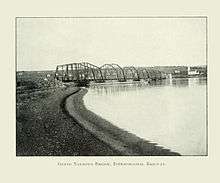 Grand Narrows Bridge in 1900 | |
| Coordinates | 45°57′35.75″N 60°48′1.03″W / 45.9599306°N 60.8002861°WCoordinates: 45°57′35.75″N 60°48′1.03″W / 45.9599306°N 60.8002861°W |
| Carries | 1 rail line (Cape Breton and Central Nova Scotia Railway) |
| Crosses | Bras d'Or Lake at the Barra Strait |
| Locale | Cape Breton Island (Iona, Victoria County, Nova Scotia – Grand Narrows, Cape Breton Regional Municipality) |
| Official name | Grand Narrows Bridge |
| Other name(s) | Barra Strait Railway Bridge |
| Maintained by | Cape Breton and Central Nova Scotia Railway |
| Characteristics | |
| Design | Truss bridge |
| Total length | 516.33 m (1,694 ft) |
| Width | 1 rail line |
| Longest span | 73.76 m (242.0 ft) |
| History | |
| Constructed by | Isbester and Reid |
| Fabrication by | Dominion Bridge Company |
| Construction start | 1887 |
| Construction cost | $530,000 |
| Opened | 18 October 1890 |
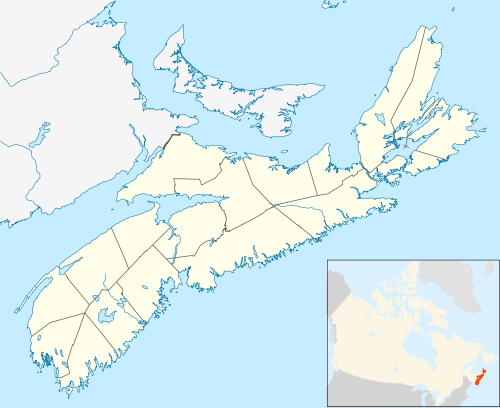 Grand Narrows Bridge Location in Nova Scotia | |
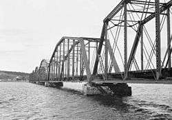
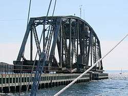
The Grand Narrows Bridge is a Canadian railway bridge crossing between Victoria County, Nova Scotia, and Cape Breton County. At 516.33 m (1,694 ft), it is the longest railroad bridge in the province. The bridge incorporates a swing span at its eastern end to permit the continued passage of marine traffic through the strait.
It is an arch truss design, consisting of seven riveted steel trusses, each 73.76 metres (242 ft) long, set on cut stone piers. The Grand Narrows Bridge crosses the Barra Strait of Bras d'Or Lake, carrying the Sydney Subdivision of the Cape Breton and Central Nova Scotia Railway between Iona, Victoria County, on the West side, and Grand Narrows, Cape Breton County (Cape Breton Regional Municipality) on the east side.
Construction
In 1887 the firm of Isbester and Reid contracted to build the foundations of a bridge at Grand Narrows, Cape Breton, and a 46-mile stretch of the Intercolonial Railway between the narrows and Point Tupper, near Port Hawksbury.[1]
Work was under way by 1889 when one of the principals of the firm, Robert Gillespie Reid, arrived on site and spent some three weeks testing sea bed sediments and measuring the currents running through the Barra Strait.[2] This was necessary as the strait is deep, over 50 metres (164 ft) deep at its southern end and still over 28 metres (92 ft) deep at the site chosen for the new bridge at the northern limit of the strait between Uniacke Point to the west and Kelly Point to the east. Other complicating factors in the construction of the bridge were the very strong, erratic tidal currents in the strait, overburden on the bedrock, and the presence of ice during the winter and spring breakup.[3]
While the actual length of this structure was not extraordinary, at around seventeen hundred feet, the actual process of laying the masonry foundation was.[4]
Cofferdams, made of timber, were built on shore, ballasted, and floated out into the channel. These were then sunk in the locations where the bridge piers were to be built and sections were added to the tops until the dams reached from the surface to the bottom of the channel, resting on the floor of the strait. The dams were heavily ballasted around their outer walls, then pumped dry so excavation of the overburden could begin. Once bedrock was reached a flat area was quarried out and long anchor bolts were sunk into the rock below.[3]
The seven cut stone bridge piers were then constructed inside the cofferdams, starting from bedrock, building up to a level about 4 or 5 feet above the surface of the water in the strait.[3]
The bridge trusses had been prefabricated in Montreal by the Dominion Bridge Company, and were shipped to Grand Narrows. An iron forge was set up on the site for the express purpose of producing rivets, and assembly of the trusses was started, first onshore, and then completed on scows floating in the water.[3][4] These completed trusses were then floated out into the strait, jacked up and lowered into their positions on the bridge piers.[3]
R.G. Reid built the Grand Narrows Bridge for the Intercolonial Railway for $530,000.[3]
Official opening
At midnight on October 18, 1890, the five-car special train of Governor General Lord Stanley left Halifax, and arrived at Mulgrave in the early morning. The five cars were ferried across the Strait of Canso, and reassembled into a train at Point Tupper, with the Intercolonial Railway Company's locomotive #166 in front. At Iona, Lord Stanley (best remembered as the donor of hockey's Stanley Cup) formally declared the railway to Sydney open for traffic, and then himself drove the train across the Grand Narrows bridge. The official train reached Sydney at 7:10 pm, touching off celebrations that lasted well into the night.[5]
References
- ↑ "Dictionary of Canadian Biography Online - REID, Sir ROBERT GILLESPIE". The Dictionary of Canadian Biography. Retrieved May 8, 2012.
- ↑ McGrath, J.W. (1971). R.G. Reid and the Newfoundland Railway. St. John’s, Newfoundland: Newfoundland Historical Society. p. 8.
- 1 2 3 4 5 6 "Cape Breton's Magazine - Issue 23 - Page 15 - Building the Grand Narrows Bridge". Ronald Caplan. Retrieved May 8, 2012.
- 1 2 MacKenzie, Michael (1984). "Intercolonial Railway: Cape Breton Line". Glimpses of the Past. Grand Falls, Newfoundland: Robinson-Blackmore. p. 55.
- ↑ Campbell, Brian (1995). Tracks Across The Landscape, The S&L Commemorative History. Sydney, Nova Scotia: University College of Cape Breton Press. p. 34.
- Notes
- Nautical chart #4278 GREAT BRAS D'OR AND / ET ST PATRICKS CHANNEL (IONA AND / ET GRAND NARROWS), published by Canadian Hydrographic Service, 1998