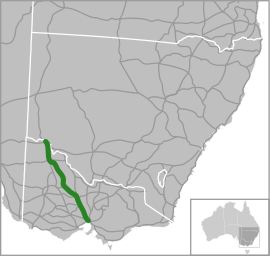
Calder Highway
| Calder Highway New South Wales–Victoria | |
|---|---|
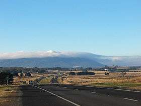 | |
| Calder Freeway facing Mount Macedon | |
 | |
| General information | |
| Type | Highway |
| Length | 561 km (349 mi) |
| Route number(s) | |
| Former route number |
|
| Major junctions | |
| NW end |
|
| SE end | |
| Location(s) | |
| Major settlements | Mildura, Ouyen, Charlton, Bendigo, Harcourt, Malmsbury, Kyneton, Woodend, Macedon, Gisborne, Diggers Rest, Sunbury |
| Highway system | |
Calder Highway[3] is a highway in Australia, linking Melbourne in Victoria, to Bendigo and Mildura and the Victoria/New South Wales border on the way to Broken Hill. It continues through New South Wales to Broken Hill, Tibooburra and the New South Wales/Queensland border as the Silver City Highway, posted as route B79 as far as Broken Hill.[4]
The highway is called the Calder Freeway south of Bendigo where it has been upgraded to freeway-standard, superseding sections of the original Calder Highway. It has been extended in phases from the southern end to Ravenswood South subsuming the older Calder Highway stretches. The Victorian Government completed the duplication of the Calder Highway from Melbourne to Bendigo to freeway conditions on 20 April 2009.
History
The Calder Highway was named after William Calder, who was chairman of the Country Roads Board (CRB) from 1913 to 1928. The CRB was renamed Victorian Road Construction Authority and is today known as VicRoads.
The highway was originally allocated a National Route 79 shield. With Victoria's conversion to the newer alphanumeric system in the late 1990s this was altered to an A79 designation for the highway portion, M79 designation for the freeway portion into Melbourne, and the New South Wales section allocated B79 in 2013.
Originally, the Calder Highway (an undivided highway) started at the end of Keilor Road in Niddrie. In the early 1970s the road was upgraded to freeway standard together with the Tullamarine Freeway, ending in Keilor East in suburban Melbourne and rejoining the Calder Highway. By the early 1980s the Freeway was extended to Keilor and then rejoined the Calder Highway. However, it was not until the 1990s that work began to duplicate the rest of the highway to Bendigo.
The Calder Highway between the Melton Highway and the Western Ring Road is shown in the 1969 Melbourne Transportation Plan as part of the F4 Freeway corridor, which extends past the Tullamarine Freeway and Bell Street to Templestowe.
Route
South of the Victoria/New South Wales border the highway is a two-lane, single carriageway in each direction, continuing through northwest Victoria from the Abbotsford Bridge, through Merbein to the major regional town of Mildura, where it is 2 lanes each way through southern Mildura and Irymple, in the state's north-west. Here also it crosses the Sturt Highway (A20) leading to capital cities Adelaide heading west and Sydney heading east. Further south, it crosses the Mallee Highway (B12) at Ouyen and runs south-east eventually to Bendigo. Between Red Cliffs and Wycheproof the highway has a speed limit of 110 km/h.
The Calder Alternate Highway (A790) bypasses the Bendigo suburban area. Its southern end is just north of Ravenswood and the northern end is at Marong, west of Bendigo.
For most of its length from Ravenswood South to the junction with the Tullamarine Freeway in Melbourne, the Calder Freeway is a four lane dual carriageway freeway which bypasses the towns the old alignment of the highway used to serve. The Old Calder Highway has been designated C794 from where it leaves the new Calder Freeway at Ravenswood South.
The north-western end of the freeway is also duplexed with the A300 until south of Harcourt where the highway resumes south-westerly to the major regional centres of Castlemaine, Ballarat, and Geelong.
Towns bypassed by, but still accessible from, the Calder Freeway include: Harcourt, Elphinstone, Taradale, Malmsbury, Kyneton, Woodend, Macedon, Gisborne, and Diggers Rest.
It gains the State Route 40 shield at the Green Gully Road interchange in Keilor, which continues east onto the Tullamarine Freeway city-bound.
The freeway ends at the interchange with the Tullamarine Freeway, the main route from the central business district to Melbourne Airport. Continuing on the Tullamarine Freeway eventually brings vehicles onto CityLink, and thus, central Melbourne.
Within the urban section of the Calder Freeway (between Kings Road and the Tullamarine Freeway), the standard travel time, in each direction, is 10 minutes. (5 minutes between Kings Road and the Western Ring Road and 5 minutes between the Western Ring Road and the Tullamarine Freeway.
The usual peak period travel time, is between 9–13 minutes. However, when there is extreme congestion or roadworks, including being residual from an incident, the travel time can go beyond 13 minutes, sometimes upwards of 20 minutes plus.
Timeline of construction
- 1972 - 1.2 miles with 3 lanes in each direction, opened from the Tullamarine Freeway/Lancefield Road to the Calder Highway at Niddrie. This section was opened 21 April 1972, by the Minister for Local Government, the Hon. A J Hunt, MLC, at a cost of $A3m.[5]
- 1975 - Keilor East. 2 km from The Avenue to Erberus Street, opened December 1974 at a cost of A$2.5m.[6]
- 1982 - 3.8 km from Erebus Street, Keilor Park (future location of the Western Ring Road interchange) to Arundel Road, Keilor, with two lanes each direction, plus emergency stopping lanes. Opened 18 May 1982 by Minister for Transport, the Hon S M Crabb MP at a cost of A$15.5m.[7]
- 1984 – Keilor bypass. Bendigo-bound carriageway opened 17 April 1984, from Arundel Road to west of Oakbank Road. The opening of this carriageway completed the bypass of Keilor. The cost of the entire bypass from Erebus Street to west of Oakbank Road was A$30m.[8]
- 1989 – Gisborne bypass opened 17 March 1989. The 6 km bypass cost A$25m.[9]
- 1990/1991 – Oakbank Road, Keilor North to Duncans Lane, Diggers Rest. 7.7 km of newly duplicated ‘2 lane carriageway’ opened to traffic at a cost of A$14m. No exact date was given, however VicRoads Annual Reports cover the previous financial year.[10]
- 1991/1992 – 2 km of duplication completed at Ravenswood during 1991/1992 at a cost of A$1.3m.[11]
- 1993 - Diggers Rest bypass. $A32m 6.5 km bypass opened to traffic in July 1993, followed by the Vinyard Road interchange in November 1993.[12]
- 1994 – Ravenswood section. Duplication of the highway completed ‘in 1994’[12]
- 1995 - Kyneton bypass opened to traffic in April 1995, at a cost of A$31m.[13]
- 1996 - Gap Hill section (Diggers Rest to Millett Road). Opened in May 1996, at a cost of A$32m.[14]
- 1998 - Gisborne South to Gisborne. 6 km completed at a cost of A$31 and opened to traffic on 3 April 1998.[15]
- 2000 - Gisborne to Woodend (Black Forest section). 6.8 km section opened to traffic on 17 March 2000. Completed at a cost of A$51m.[16]
- 2001 - Woodend bypass. 13.5 km bypass opened to traffic on 19 December 2001. The total cost of the project was A$85m.[17]
- 2003 - Carlsruhe section. 6.5 km section opened to traffic on 16 April 2003, at a cost of A$46m. This section completed the dual carriageways from Keilor to Kyneton.[18]
- 2005 – 2.5 km north of Kyneton completed in January 2005.[19]
- 2005 – Ravenswood. 6.5 km duplication south of Ravenswood completed in May 2005[19]
- 2008 – 15 km Malmsbury section opened in April 2008.[20]
- 2009 – Harcourt North to Elphinstone opened on 20 April 2009. This 19 km section cost A$404m and completed the duplication of the highway between Melbourne and Bendigo. The project was jointly funded by the state and federal governments.[21]
Upgrades
Calder Highway / Calder Alternative Route intersection
The upgrade of the intersection of the Calder Highway and Calder Alternate Route at Ravenswood, is being funded jointly by the Victorian and Commonwealth Governments. It began construction in February 2016 with completion anticipated by the end of 2017.[22][23]
Western Ring Road to Kings Road
In 2008, VicRoads completed the widening of the Calder Freeway from the Western Ring Road to Melton Highway. The road was widened from 2 lanes each direction to 3 lanes in each direction. The speed limit was reduced permanently from 100 km/h to 80 km/h.[24] The 80 km/hr limit applies northbound from Keilor Park Drive to the Service Centre at Calder Park, and southbound it applies from the Green Gully Road bridge to just prior to the Western Ring Road interchange. In October 2010, it was announced that as part of a year long trial, the speed limit on this section of freeway will be increased back to 100 km/h in off-peak times (8pm-5am), with 30 variable speed limits{{subst:clarify}} to be installed along the stretch of freeway. As of 2011, the section combined with State Route 40 (or essentially Keilor Park Dve to Kings Road) is permanently signed at 80 km/h - with slight differences (as noted) inbound and outbound. A further upgrade completed in 2012 resulted in a new interchange at Kings Road (the freeways's urban / metropolitan limits) and closure of three at grade intersections in the area. Despite the upgrade the 80 km/h speed limit remains today.
Gallery of notable sights
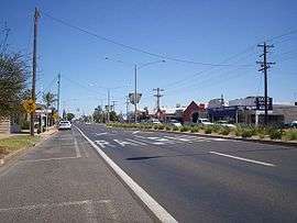 The Calder Highway, passing through Irymple.
 The end of the Calder Highway at the intersection of the Silver City Highway, near Curlwaa, New South Wales.
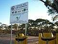 Fruit disposal bins and warning signs along the Calder Highway, approaching the Fruit Fly Exclusion Zone near Mildura.
Major Intersections and Towns
| State | LGA | Location | km[25] | mi | Destinations | Notes |
|---|---|---|---|---|---|---|
| New South Wales | Wentworth | Curlwaa | 565 | 351 | ||
| Murray River | 564.5 | 350.8 | Abbotsford Bridge | |||
| State border | New South Wales – Victoria state border | |||||
| Victoria | Mildura | Merbein | 553.5 | 343.9 | ||
| Mildura | 544 | 338 | ||||
| 541 | 336 | |||||
| 539 | 335 | |||||
| Irymple | 537 | 334 | ||||
| Red Cliffs | 528 | 328 | ||||
| 526 | 327 | |||||
| 525 | 326 | Kulkyne Way – Colignan | ||||
| Hattah | 476 | 296 | ||||
| Ouyen | 440.8 | 273.9 | ||||
| 440.7 | 273.8 | |||||
| 430 | 270 | |||||
| Mittyack | 404 | 251 | ||||
| Buloke | Bimbourie | 371 | 231 | |||
| Sea Lake | 356 | 221 | ||||
| 352 | 219 | concurrent with C246 through Sea Lake | ||||
| 351.5 | 218.4 | |||||
| Dumosa | 291 | 181 | ||||
| Wycheproof | 276 | 171 | ||||
| 275 | 171 | |||||
| Wycheproof South | 269 | 167 | ||||
| Charlton | 246 | 153 | ||||
| 245 | 152 | |||||
| 244 | 152 | |||||
| Loddon | Wedderburn | 213.7 | 132.8 | concurrent with C273 past Wedderburn oval | ||
| 213.5 | 132.7 | |||||
| Inglewood | 185 | 115 | ||||
| Bridgewater | 178 | 111 | ||||
| 177 | 110 | |||||
| Greater Bendigo | Marong | 155 | 96 | |||
| Golden Square | 155 | 96 | ||||
| Ironbark | 153 | 95 | ||||
| 152.4 | 94.7 | |||||
| Bendigo | 150 | 93 |
| concurrent with A300 | ||
| Golden Square | 147.4 | 91.6 | ||||
| Kangaroo Flat | 145 | 90 | ||||
| Ravenswood | 135 | 84 | ||||
| Harcourt North | 126 | 78 | Continues as Calder Freeway | |||
| Mount Alexander | Ravenswood South–Harcourt North boundary | 0 | 0.0 | Northern freeway terminus: continues as Calder Highway; at-grade intersection | ||
| Barkers Creek–Harcourt boundary | 5.8 | 3.6 | A300 southern concurrency terminus | |||
| Elphinstone | 18.3 | 11.4 | ||||
| Macedon Ranges | Malmsbury | 32.8 | 20.4 | |||
| Kyneton | 36.1 | 22.4 | At-grade intersection | |||
| 41.2 | 25.6 | |||||
| 43.6 | 27.1 | Northbound exit and southbound entrance only | ||||
| Carlsruhe | 18.4 | 11.4 | Springvale Road – Carlsruhe | |||
| Woodend North | 51.6 | 32.1 | Southbound exit and northbound entrance only | |||
| Woodend | 56.8 | 35.3 | ||||
| Macedon | 64.2 | 39.9 | ||||
| 70.5 | 43.8 | Northbound exit and southbound entrance only | ||||
| Gisborne–New Gisborne boundary | 72.6 | 45.1 | ||||
| Gisborne | 75.5 | 46.9 | ||||
| Macedon Ranges–Hume boundary | Gisborne South–Sunbury boundary | 81.5 | 50.6 | Couangalt Road west / Mundy Road east – Gisborne South, Sunbury | ||
| Hume–Melton boundary | Sunbury–Diggers Rest boundary | 86.5 | 53.7 | |||
| 91.5 | 56.9 | |||||
| Diggers Rest | 94.7 | 58.8 | Bulla–Diggers Rest Road – Bulla, Diggers Rest | |||
| Brimbank | Calder Park–Keilor North boundary | 97.8– 99.1 | 60.8– 61.6 | Holden Road west – Toolern Vale | Northbound exit and entrance; northbound and southbound access to service centres | |
| 99.8 | 62.0 | Organ Pipes Road – Organ Pipes National Park | At-grade intersection | |||
| 101 | 63 | Calder Park Drive – Calder Park | Northbound exit and entrance only | |||
| Keilor North–Taylors Lakes boundary | 102 | 63 | Kings Road – Taylors Lakes, Deer Park, Laverton | |||
| Keilor North–Keilor Lodge boundary | 104 | 65 | Northbound exit and entrance only | |||
| Keilor | 105 | 65 | Partial Y interchange: northbound exit and southbound entrance | |||
| 107 | 66 | North-westbound exit and south-eastbound entrance only; State Route 40 north-western concurrency terminus | ||||
| Keilor Park–Keilor East boundary | 110 | 68 | No north-westbound exit | |||
| 111 | 69 | Incomplete access: no exit north-westbound to north-eastbound or south-eastbound to south-westbound, no entrance south-westbound to south-eastbound or north-westbound to north-eastbound; access from north-westbound exit to Keilor Park Drive | ||||
| Moonee Valley | Keilor East–Airport West boundary | 112 | 70 | Woorite Place – Keilor East, Airport West | North-westbound exit and south-eastbound entrance only | |
| Airport West–Niddrie boundary | 113 | 70 | Fullarton Road / McNamara Avenue – Niddrie | South-eastbound entrance and exit only | ||
| 113.3 | 70.4 | Keilor Road / Newman Street – Niddrie | North-westbound entrance and exit only | |||
| 113.7 | 70.6 | North-westbound exit and south-eastbound entrance | ||||
| Airport West–Niddrie–Essendon Fields–Essendon North quadripoint | 114 | 71 | Partial Y interchange: no access eastbound to northbound or southbound to westbound | |||
| ||||||
See also
References
- ↑ National Routes, Main Roads Victoria. Retrieved on 26 August 2013.
- ↑ Freeway Route Numbering System, Main Roads Victoria. Retrieved on 26 August 2013.
- ↑ Calder Freeway & Calder Highway (M/A79), Expressway - Paul Rands. Retrieved on 11 September 2013.
- ↑ Silver City Highway, Tibooburra, 2007-12-25
- ↑ Country Roads Board Victoria. Fifty-Ninth Report: for the year ended 30th June, 1972, Burwood, Victoria: Brown, Prior, Anderson, 1972. p. 5
- ↑ Country Roads Board Victoria. Sixty-Second Annual Report: for the year ended 30th June, 1975, Burwood, Victoria: Brown, Prior, Anderson, 1975. p. 5.
- ↑ Country Roads Board Victoria. 69th Annual Report. 1981-1982, Kew, Victoria: Country Roads Board Victoria, 1982. p. 11
- ↑ Road Construction Authority Victoria. 1st Annual Report 1983-84, Kew, Victoria: Road Construction Authority, Victoria, 1984. p. 10
- ↑ Road Construction Authority Victoria. Annual Report 1988-1989, Kew, Victoria: Road Construction Authority, Victoria, 1989. p. 46
- ↑ VicRoads. VicRoads Annual Report, 1990-1991, Kew, Victoria: VicRoads, 1991, p. 37
- ↑ VicRoads. VicRoads Annual Report, 1991-1992, Kew, Victoria: VicRoads, 1992, p. 42
- 1 2 Vicroads. Vicroads Annual Report 1993-94, Kew, Victoria: Vicroads, 1994, p. 16
- ↑ Vicroads. Vicroads Annual Report 1994-95, Kew, Victoria: Vicroads, 1995, p. 9
- ↑ Vicroads. Vicroads Annual Report 1995-96, Kew, Victoria: Vicroads, 1996, p. 15
- ↑ Vicroads. Vicroads Annual Report 1997-98, Kew, Victoria: Vicroads, 1998, p. 33
- ↑ Vicroads. Vicroads Annual Report 2000-01, Kew, Victoria: Vicroads, 2000, p. 27
- ↑ Vicroads. Vicroads Annual Report 2001-02, Kew, Victoria: Vicroads, 2002, p. 33
- ↑ Vicroads. Vicroads Annual Report 2002-03, Kew, Victoria: Vicroads, 2003, p. 13
- 1 2 Vicroads. Vicroads Annual Report 2004-05, Kew, Victoria: Vicroads, 2005, p. 33
- ↑ VicRoads. VicRoads Annual Report 2007-08, Kew, Victoria: VicRoads, 2008, p. 35
- ↑ VicRoads. VicRoads Annual Report 2008-09, Kew, Victoria: VicRoads, 2009, p. 41
- ↑ "Ravenswood Interchange". VicRoads. 20 October 2015. Retrieved 6 January 2017.
- ↑ Luke Donnellan, Minister for Roads and Road Safety, Government of Victoria (1 April 2016). "New Ravenswood Interchange moving ahead with CPB contractors". Retrieved 6 January 2017.
- ↑ Gardiner, Ashley (12 June 2008). "Freeway slowdown to ease traffic jams in Melbourne". Herald Sun. Retrieved 1 July 2008.
- ↑ Google (20 January 2015). "Calder Highway" (Map). Google Maps. Google. Retrieved 20 January 2015.
Road infrastructure in Melbourne | |
|---|---|
| Freeways | |
| Highways |
|
| Bypasses | |
| Bridges and tunnels | |
| Proposals | |
| |