Charlton, Victoria
| Charlton Victoria | |||||||||
|---|---|---|---|---|---|---|---|---|---|
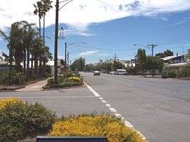 Charlton's High Street | |||||||||
 Charlton | |||||||||
| Coordinates | 36°16′0″S 143°21′0″E / 36.26667°S 143.35000°ECoordinates: 36°16′0″S 143°21′0″E / 36.26667°S 143.35000°E | ||||||||
| Population | 1,050 (2016 census)[1] | ||||||||
| Postcode(s) | 3525 | ||||||||
| Elevation | 117 m (384 ft) | ||||||||
| Location | |||||||||
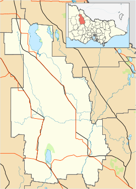
| LGA(s) | Shire of Buloke | ||||||||
| State electorate(s) | Ripon | ||||||||
| Federal Division(s) | Mallee | ||||||||
| |||||||||
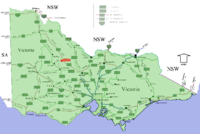
Charlton "The Friendly River Town", is a town in Victoria, Australia. It is a small agricultural community straddling the Avoca River, located at the junction of the Calder Highway (A79) and Borung Highway (C239) and positioned in the last of the foothills of the Great Dividing Range. Its location, almost halfway between Melbourne and Mildura, makes Charlton a popular stop along the way for tourists.
History
The original inhabitants of the region were the Jaara Aborigines. After extensive travels throughout the region by Major Thomas Mitchell, settlement by Europeans occurred in 1848 when Robert Cay and William Kaye established a station and named the region after a town in Greenwich, England. Unlike many other towns in the region, Charlton was not established as a result of gold mining, but for pastoral purposes and the proximity to a permanent water supply (the Avoca River). The original town was named East Charlton due to its location on the eastern banks of the Avoca River, and the fact that another town in the Victoria was named Charlton (renamed Chute in 1879). The East Charlton Post Office opened on 21 December 1876 (renamed Charlton in 1879) replacing an earlier (1854) office nearby named Yowen Hill.[2]
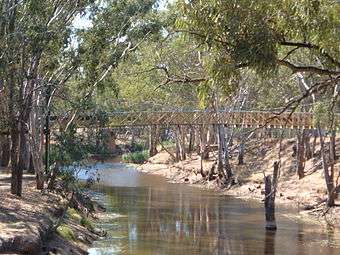
The first bridge to cross the river was erected in 1867 by James Paterson, allowing for expansion on both sides of the river. Throughout the history of Charlton, the Avoca River has been known for its spontaneous flooding after heavy rain showers, resulting in many floods that often surrounded the town or on rare occasions flooded the town. Levee banks were constructed to their present levels in the 1950s, however parts of the town were flooded in September 2010.[3] Minor flooding occurred again in December 2010, with the highest ever recorded flood level inundating the town in January 2011, with some homes within the town having more than 1.6 meters of water above floor level.
One of the town's most prominent landmarks is the former hotel, the "Vale of Avoca", which was built on the site of an early bark hut inn by James & Elizabeth Egan in 1879. Built on a reef of stone, Mrs Egan named the building as being in the 'vale' or valley of the nearby Avoca River. It was delicensed as a hotel in 1942, restored in the 1990s and currently operates as a Bed and Breakfast.
The first issue of the local newspaper, the Tribune was published on 20 May 1876,[4] the founders being H. T. Henningsen and his step-son, R. M. Klunder. For many years the Tribune was published twice weekly — Wednesdays and Saturdays — but during the Second World War shortage of staff and paper necessitated the change to a weekly paper. In 1925 the business was purchased by Messrs Hogan and Gardiner and then followed other proprietors, Herbert Davies and John S. Richardson, and by his widow, Rena M. Richardson, after his death in 1954. In February 1960, Rena Richardson married William Wood and in 1961 she sold the Tribune to Ian and Coral Cameron. In 1981, the newspaper was sold by the Camerons to the St. Arnaud Mercury and the Mercury and the Tribune were combined to become the North Central News.
Demographics
Charlton is the second largest town in the Shire of Buloke. At the 2011 census, its "state suburb" population, which includes some surrounding areas, was 1,288.[1] Its "urban centre" population in 2011 was 968,[5] down from 1,072 at the 2006 census.[6] Government department downsizing in addition to regional economic decline led to the largest percentage decline in population within Victoria between the mid-1980s and the mid-1990s with an estimated 18.3% loss in population.[7] Recent agricultural developments (such as the AWB Limited facilities), a sharp increase in house prices within larger urban areas, in addition to economic recovery, have resulted in a shift towards stabilisation and a subsequent increase in population. However, more than 60% of all local businesses are for sale or remain closed.
Economy
The economic backbone of Charlton exists almost entirely in agriculture and services. A number of massive grain silos dominate the town skyline, evidence of the town's rich history in various grains including wheat, oats and barley. Sheep and cattle farming are also prolific with the largest beef feedlot in the state, situated in Yeungroon just south of the town. Recent additions to the region, including an olive farm and winery have diversified the town's agricultural applications.
Major employers in the Charlton area are:
- AWB Limited (Grains)
- Boral (Quarry - Mostly for road aggregate)
- Buloke Shire Council (Local Government)
- Charlton Feedlot (Livestock)
- Charlton P-12 College, Cluster Centre and Saint Joseph's Primary School (Education)
- Graincorp (Grains)
- Lake Marmal Vineyards (Grapes)
- Timbercorp (Olives)
Transport
Charlton has one public transport connection to Melbourne, a single V/Line coach service serving the town, once a day, five days per week which connects with a train service at Bendigo that goes to Melbourne. Charlton used to have its own railway station on the Kulwin line, although a bare platform remains and no passenger services operate on the line. The line only carries wheat trains.
Climate
Charlton enjoys a Mediterranean style climate, with long hot summers and mild wet winters. Deep blue skies are regular throughout much of the year as are crystal clear starry nights. Charlton's January average max/min temperatures are 30.4 °C (86.7 °F)/13.8 °C (56.8 °F) and July average max/min temperatures are 13.4 °C (56.1 °F)/3.4 °C (38.1 °F). Annual precipitation is 430.8 mm (16.96") (Source: Bureau of Meteorology ). During the Black Saturday period in 2009, Charlton recorded a temperature of 47.2 C, just short of the state temperature record of 48.8 C.
| Month | Jan | Feb | Mar | Apr | May | Jun | Jul | Aug | Sep | Oct | Nov | Dec | Year |
|---|---|---|---|---|---|---|---|---|---|---|---|---|---|
| Avg high (C) | 30.4 | 30.2 | 26.7 | 21.8 | 17.4 | 13.9 | 13.4 | 15.0 | 18.0 | 21.4 | 25.5 | 28.7 | 21.9 |
| Avg low (C) | 13.8 | 14.3 | 11.8 | 8.4 | 6.0 | 4.1 | 3.4 | 4.0 | 5.5 | 7.5 | 10.0 | 12.4 | 8.4 |
| Rainfall (millimetres) | 24.3 | 27.2 | 28.3 | 32.2 | 42.7 | 48.1 | 43.2 | 45.2 | 42.6 | 41.8 | 28.4 | 26.8 | 430.8 |
Facilities

Charlton's central location to the North Central region has resulted in the town being the beneficiary of considerable services not typically associated with such small localities.
- The Traveller's Rest is an iconic 'toilet block', held very proudly by the locals, situated in the heart of the town within easy walking of shops and restaurants. Containing picnic facilities, a wishing well, gazebo, views of the river, a footbridge across the river and overnight stop facilities, the Traveller's Rest is a regular stop for tourists, the V/Line bus service and various other tour groups.
- Sporting facilities are of a high standard, catering to a diversity of sports participated in by locals and visitors. Football (Australian rules football), hockey, netball, cricket, basketball, bowls and tennis dominate the Charlton sporting calendar. Charlton has a football team competing in the North Central Football League. Additionally, the harness racing track is a central feature of the town and region, holding regular meets run by the Charlton Harness Racing Club that are televised and broadcast on radio nationally.[8]
- The Rex Theatre is a fully restored cinema and live theatre serving and operated by the community with various memorabilia and modern movies.
- The town exhibits education facilities for residents from kindergarten to the end of high school. There is also a cluster centre that is now part of the P-12 Charlton College, providing additional education services for students and further education for adults.
- A comprehensive "driver-training" facility is located within the town, assisting young drivers in learning the rules of the road.
Recreation and tourism
The river winds through the town with trees and parks lining the banks. Along the river is a 2 km walking track connecting High Street to Charlton Park, where sporting and recreational facilities exist.
- The Charlton Golden Grains Museum[9] has information about the town and its history. The museum is open by appointment.
- 2 km west of town is the Charlton golf course.[10] Built in a clover leaf format, containing three arms of six holes each, the golf course is in the nearby Dooboobetic Hills. Kangaroos and other native flora and fauna are seen on the course.
- 5 km southeast of the town, views of the region are to be had from Barrakee Hill, or "Quarry Hill" to the locals.
- 14 km west of the town are the Wooroonook Lakes, providing facilities for water sports enthusiasts, duck shooting, picnickers and campers.
- 25 km east of the town is Wychetella Forest, containing many native animals, including the rare malleefowl.
Events
- Annual Australia Day Tennis Tournament - Held over the Australia Day Long Weekend in January
- Art Show - Held every October
- Charlton A & P Society Annual Show, held the 3rd weekend in October
- Charlton Fishing Competition - Held every November
- Charlton Harness Racing Cup - Held every March
- Redback Rally - Motorcycle rally, held the second weekend of February
- Charlton Film Festival held at the Rex Theatre every February.
- Buloke Shire Council official website
- Charlton weather
Gallery
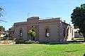 Charlton Mechanics Institute
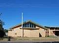 Anglican Church
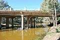 Charlton Avoca River Bridge
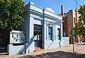 Charlton Bank of Australasia
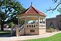 Green Memorial Rotunda
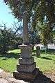 Charlton Boer War Memorial
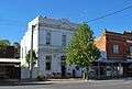 Building
References
- 1 2 Australian Bureau of Statistics (27 June 2017). "Charlton (State Suburb)". 2016 Census QuickStats. Retrieved 2 May 2018.

- ↑ Premier Postal History, Post Office List, retrieved 2008-04-11
- ↑ "Town shuts down as water floods main street". 9 News. 6 September 2010. Retrieved 2010-09-06.
- ↑ "Carmody.pdf" (PDF). pdf.js. 2014. Retrieved 28 September 2014.
- ↑ Australian Bureau of Statistics (31 October 2012). "Charlton (Urban Centre/Locality)". 2011 Census QuickStats. Retrieved 5 December 2014.
- ↑ Australian Bureau of Statistics (25 October 2007). "Charlton (Urban Centre/Locality)". 2006 Census QuickStats. Retrieved 5 December 2014.
- ↑ Australian Bureau of Statistics (3 June 1998). "4102.0 - Australian Social Trends, 1998". Retrieved 5 December 2014.
- ↑ Australian Harness Racing, Charlton, retrieved 2009-05-11
- ↑ http://charltongoldengrainsmuseum.webs.com/
- ↑ Golf Select, Charlton, retrieved 2009-05-11
External links
![]()