Tullamarine Freeway
| Tullamarine Freeway Victoria | |
|---|---|
 | |
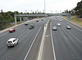
| Tullamarine Freeway looking south at Airport West | |
| General information | |
| Type | Freeway |
| Length | 13 km (8.1 mi) |
| Opened | 1965-1979 |
| Route number(s) |
|
| Former route number | |
| Major junctions | |
| Northwest end |
|
| |
| Southeast end |
|
| Location(s) | |
| Major suburbs / towns | Gladstone Park, Essendon, Pascoe Vale |
| Highway system | |
The Tullamarine Freeway (commonly referred to as The Tulla), is a major urban freeway in Melbourne, linking Melbourne Airport to the Melbourne City Centre. It carries up to 210,000 vehicles per day and is one of Australia's busiest freeways. The entire stretch of the Tullamarine Freeway bears the designation M2 (previously State Route 43 from 1989 to early 2018). The freeway was originally shown in the 1969 Melbourne Transportation Plan as part of the F14 Freeway corridor.
History
The Tullamarine Freeway is one of the oldest freeways in Melbourne. The first stage of construction was completed in the financial year 1965/66 between Mickleham Road and "the Tullamarine Jetport Terminal area" (Melbourne Airport),[4] with the initial 7.2-kilometre (4.5 mi) section between Melbourne Airport and Lancefield Road at Essendon Airport officially opening early 1968. This section was originally referred to as the "Tullamarine By-pass Road".[5] From Essendon, a new section heading east to Pascoe Vale and then south along the Moonee Ponds Creek to Mt Alexander Road, Flemington was opened to traffic in 1970.[6] This new section replaced Mount Alexander Road as the main route to the city. In 1979, the section of Lancefield Road running along the western edge of Essendon Airport was upgraded to freeway standard, completing the freeway.[7]
The freeway was initially designated F81 for the whole stretch from Tullamarine to Flemington. The freeway was originally designated in the 1969 Melbourne Transportation Plan as the F14 Freeway corridor.
With its completion, city-bound heavy vehicles from Hume Highway were diverted here via Pascoe Vale Road. In the 1990s, the completion of the Western Ring Road increased traffic tremendously. It was only relieved by the completion of CityLink, widening the freeway to 8 lanes (two of these being transit lanes) and extending it south to the West Gate Freeway. The improved sections are now tolled.
The freeway is used by Skybus Super Shuttle services to Melbourne Airport, and in 2002 the Victorian government contributed $3 million to a $10 million plan to expand and improve these services, after a feasibility study into an airport rail link found the number of passengers using a train would not make the scheme economically viable.[8]
The Calder Freeway interchange was completed earlier than expected in mid-2007, which underwent dramatic roadworks to alleviate congestion. All works are now complete, with the end result being the decommissioning and removal of two off-ramps, an additional two lanes inbound, and dedicated Bulla Road-Calder Freeway spurs to eliminate weaving, notorious for many accidents in the area.
Another project now completed is a new bridge and northern entrance to the Essendon Airport through the interchange of Melrose Drive, to provide easy access for the people living in the northern suburbs to access the Essendon Airport district.
Timeline of construction
- 1965/66 - Melbourne Airport ("Tullamarine By-pass Road"). 2.9 kilometres (1.8 mi) of 4-lane dual carriageways completed from Mickleham Road to 'the Tullamarine Jetport Terminal area'. At this stage, the airport interchange, bridges and access roads were still under construction.[4]
- 1967/68 – Still referred to as the Tullamarine By-pass Road. 7.2 kilometres (4.5 mi) opened to traffic between Essendon Airport and Tullamarine Airport.[5]
- 1970 – 18 kilometres (11 mi) opened 3 February 1970, by Sir Henry Bolte, MLA, Premier of Victoria. Including the previously constructed 3 kilometres (2 mi) from Bell Street to the southern boundary of Essendon Airport and 8 kilometres (5 mi) from Essendon Airport to Tullamarine Airport. The 6 kilometres (3.5 mi) section from Flemington Bridge to the Bell Street interchange was built by the Melbourne and Metropolitan Board of Works. Total cost: $14.94m.[6]
- 1979 - 1.6 km along western boundary of Essendon Airport (previously Lancefield Road) upgraded to freeway standard. Opened 18 December 1979, by Minister for Transport, the Hon Robert Maclellan MLA, at a cost of $7.8m.[7]
Route description
Currently the official start of the freeway is at Pascoe Vale Road, as the original southern sections was upgraded in the late 1990s as part of CityLink. Here it is a three lane, high quality dual carriageway, running along the south side of Essendon Airport and the Direct Factory Outlets shopping complex, the former main airport of Melbourne. At the Calder Freeway interchange, staying to the right will lead you to the next section of the Tullamarine Freeway.
The next section is quite narrow, with two lanes running either way and a concrete barrier (later grass and shrubbery) in the middle of the road. Melrose Drive runs alongside its airport-bound side. This section is frequently congested due to the combination of freight traffic from the Hume Highway, which is accessed from the Western Ring Road interchange, and the traffic from the airport. After the ring road interchange, the traffic is slightly better, leading to the Melbourne Airport off ramp, after which the freeway ends.
The travel time on the Tullamarine Freeway in both directions, is 16 minutes. (Inbound: 4 minutes between Melbourne Airport and the Western Ring Road, 5 minutes between the Western Ring Road and Bell Street and 7 minutes between Bell Street and the West Gate Freeway. Outbound: The exact same, except 8 minutes from the West Gate Freeway to Pascoe Vale Road and 3 minutes from the Western Ring Road to Melbourne Airport).
The usual peak period travel time is between 19–30 minutes. It is usually around 19 minutes for the majority of the daylight hours inbound, because there is only one lane to merge with the West Gate Freeway city bound, hence slowing traffic over the Bolte Bridge section. However, during times of extreme congestion, including being residual due to an incident, the travel time can well exceed half an hour.
Citylink–Tulla Widening (2015–2018)
Project Overview
In August 2015 a proposal to Widen the Citylink and Tullamarine Freeway was put in order which consists of 2 Stages which would increase the road's daily capacity as well as shorten trips between Melbourne Airport and The CBD During Morning Peak and Afternoon Peak Times. The following upgrades started in October 2015 (Stage 1) and May 2016 (Stage 2). The entire project is anticipated to be complete by late 2018.
Stage 1 (Bulla Road to Power Street)
- Lane use management signs to manage which lanes are open
- Variable speed limit signs above all lanes
- Ramp signalling – stop and go traffic lights to improve traffic flow and reduce congestion as traffic enters the freeway from on-ramps
- CCTV cameras – to monitor for incidents, help response times and minimise disruptions
- Travel time information signs so people can plan their journey
- Electronic message signs – to notify road users of planned changes or disruptions
- Automatic incident detection system – to alert Road Managers incidents in real time
- 2 Dedicated Lanes Inbound to Bell Street from the Tullamarine Freeway and Calder Freeway
- New Bell Street to Pascoe Vale Road
- Improvements To Flemington Road/ Mount Alexander Road Freeway Interchange
- Additional Outbound Lane Between Moreland and Ormond Road
- Ramp Widening Between Bolte Bridge and West Gate Freeway
- One Additional Inbound Lane between Montague Street and Ingles Street
- One Additional Inbound Lane between Montague Street and Power Street
Stage 2 (Melbourne Airport to Bulla Road)
- A new structure with dedicated lanes from the Tullamarine Freeway and Mickleham Road to the M80 Ring Road inbound to ease congestion and reduce traffic weaving
- An extra lane entering the Tullamarine Freeway city bound from Mickleham Road
- Reconstruction and widening of the English Street overpass and all ramps to increase capacity into and out of Essendon Fields
- Ramp signals on the city bound entry from Kings Road in Taylors Lakes to the Tulla Calder interchange to regulate the flow of traffic getting onto the Tullamarine Freeway from the Calder Freeway
Extra Lanes
Part of The Upgrade is Adding More Lanes between Melbourne Airport and the West Gate Freeway. Between The Citylink (Western Link) and The West Gate Freeway One additional lane in each direction will be added consuming the current emergency lanes as well as lower the current speed limit from 100 km/h down to 80 km/h which sparked major controversy in the public. New Emergency Stopping Bays Similar to the Monash Freeway's Emergency Stopping Bays will be provided where Possible.
Exits and interchanges
| LGA | Location | km[9] | mi | Destinations | Notes |
|---|---|---|---|---|---|
| Hume | Melbourne Airport | 0 | 0.0 | North-western freeway terminus: continues as Sunbury Road; northbound entry from and southbound exit to Centre Road, and northbound entry from airport | |
| 0.95 | 0.59 | Northbound exit and southbound entry only | |||
| 1.3– 2.0 | 0.81– 1.2 | Mercer Drive – Melbourne Airport terminal 4 | Northbound exit and southbound entry only | ||
| Westmeadows–Tullamarine–Gladstone Park tripoint | 3.3 | 2.1 | |||
| Hume–Moreland boundary | Tullamarine–Gladstone Park–Gowanbrae tripoint | 5.1 | 3.2 | No access north-eastbound to southbound or northbound to south-westbound | |
| Moonee Valley | Airport West–Strathmore Heights–Essendon Fields tripoint | 6.3 | 3.9 | Melrose Drive north-west / Wirraway Road south-east – Airport West, Essendon Airport | No entry northbound; southbound exit to Wirraway Road only |
| Airport West–Essendon Fields–Niddrie–Essendon North quadripoint | 8.6 | 5.3 | Partial Y interchange: South-eastbound entry and north-westbound exit only | ||
| Essendon Fields–Essendon North–Strathmore tripoint | 9.5 | 5.9 | |||
| Strathmore | 10.9– 11.3 | 6.8– 7.0 | Eastbound exit and westbound entry only | ||
| 11.3 | 7.0 | South-eastern freeway terminus: continues south as CityLink | |||
| 1.000 mi = 1.609 km; 1.000 km = 0.621 mi | |||||
See also
References
- ↑ Freeway Route Numbering System, Main Roads Victoria. Retrieved 4 September 2013.
- ↑ Metropolitan Route Numbering System - 1989 Changes, Main Roads Victoria. Retrieved 4 September 2013.
- ↑ National Routes, Main Roads Victoria. Retrieved 4 September 2013.
- 1 2 Country Roads Board Victoria. Fifty-third Annual Report for the Year Ended 30th June, 1966, Melbourne, Victoria: Government Printer, 1967. p. 11, p. 47
- 1 2 Country Roads Board Victoria. Fifty-fifth Annual Report: for the year ended 30th June, 1968, Burwood, Victoria: Brown, Prior, Anderson, 1969. p. 33
- 1 2 Country Roads Board Victoria. Fifty-seventh Annual Report: for the year ended 30th June, 1970, Burwood, Victoria: Brown, Prior, Anderson, 1971. p. 1
- 1 2 Country Roads Board Victoria. 67th Annual Report. 1979–1980, Kew, Victoria: Country Roads Board Victoria, 1980. p. 9
- ↑ Better buses replace dumped rail link, The Age, 12 June 2002.
- ↑ Google (5 June 2014). "Tullamarine Freeway" (Map). Google Maps. Google. Retrieved 5 June 2014.
External links
Road infrastructure in Melbourne | |
|---|---|
| Freeways | |
| Highways |
|
| Bypasses | |
| Bridges and tunnels | |
| Proposals | |
| |
Coordinates: 37°41′45″S 144°53′11″E / 37.69591°S 144.88632°E