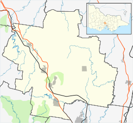
Gisborne, Victoria
| Gisborne Victoria | |||||||||||||||
|---|---|---|---|---|---|---|---|---|---|---|---|---|---|---|---|
 View down the main street from the south | |||||||||||||||
 Gisborne | |||||||||||||||
| Coordinates | 37°29′24″S 144°35′20″E / 37.49000°S 144.58889°ECoordinates: 37°29′24″S 144°35′20″E / 37.49000°S 144.58889°E | ||||||||||||||
| Population | 9,822 (2016)[1] | ||||||||||||||
| Established | 1851 | ||||||||||||||
| Postcode(s) | 3437 | ||||||||||||||
| Elevation | 443 m (1,453 ft) | ||||||||||||||
| Location | |||||||||||||||
| LGA(s) | Shire of Macedon Ranges | ||||||||||||||
| State electorate(s) | Macedon | ||||||||||||||
| Federal Division(s) | McEwen | ||||||||||||||
| |||||||||||||||
Gisborne (/ˈɡɪzbərn/)[2] is a town in the Macedon Ranges, approximately 54 kilometres (34 mi) north-west of Melbourne, Victoria, Australia. The town was named after Henry Fyshe Gisborne (1815–1841), the first Commissioner for Crown Lands of the Port Phillip District.[3].
History
The original inhabitants of Gisborne were the Dja Dja Wrung and Wurundjeri Aboriginal people. Aboriginal people have lived in the Macedon Ranges area for at least 26,000 years. The Wurundjeri, Dja Dja Wurrrung and Taungurung communities are still active. In 1834, John Aitken arrived in Melbourne and deemed the land south of Mount Macedon ideally suited to sheep grazing. He selected a sizeable area of land and in the following year, shipped merino sheep from Tasmania. Despite his ship running aground at Dromana, Aitken managed to rescue many of his flock and transport them to the Gisborne area with the help of aborigines. He named his property "Emmeline Vale," after his wife Emmeline. Aitken reared six children on the property and produced some of the finest merino wool in the Colony.[4]
From the late 1830s, many pastoralists, arriving from Tasmania and New South Wales, began taking up areas of land in the surrounding districts. The first recorded settlers were: Barbour and Matson, who settled at Bullengarook, Hill at the "Turitable Run" south of Mount Macedon, Stainforth in the area around the present Rosslynne Reservoir, and Aitken and Howey in the area to be later known as Gisborne.
Gisborne Post Office opened on 22 March 1850 as Bush Inn but was renamed Gisborne ten days later.[5]
Today
Gisborne is the largest township in the Macedon Ranges, and the closest to Melbourne's CBD, which can be accessed easily via a 45-minute drive along the Calder Freeway or a 50 minute train ride on the Bendigo Line. Together with the nearby town of Macedon, Gisborne had an estimated population of 21,071[6] at June 2016.
The town centre has a number of Melbourne-style cafes and wine bars, as well a theater[7],restaurants and galleries, monthly farmers' market[8], an organic butcher and three supermarkets stocking local produce, as well as organic, vegan and gluten-free foods.[9] Gisborne has a full-time police station in conjunction with the CFA station and medical-ambulance facilities. Sporting facilities cater for AFL football, cricket, soccer, tennis, netball gymnastics and lawn bowls as well as a heated indoor pool.
Proximity to the city and the area's natural beauty are drawing large numbers of new residents, making the local population growth rate among the fastest in regional Victoria.[10] Locals, worried about the environmental and cultural impacts of this growing popularity, successfully campaigned for new planning controls to protect the character of the region.[11]
Education
The town has two primary schools and one secondary school, Gisborne Secondary College.
Sister cities
Image gallery
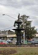 Fountain in the centre of Gisborne
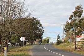 Entering Gisborne from the Bacchus Marsh road
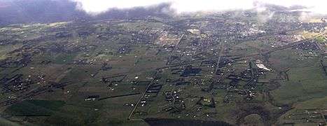 Aerial photo from east
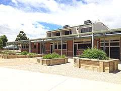 Gisborne SC Library, constructed in 2011
See also
References
- ↑ Australian Bureau of Statistics (27 June 2017). "Gisborne". 2016 Census QuickStats. Retrieved 31 October 2017.

- ↑ Macquarie Dictionary, Fourth Edition (2005). Melbourne, The Macquarie Library Pty Ltd. ISBN 1-876429-14-3
- ↑ Gisborne Online Web Site accessed 29 September 2006
- ↑ A Brief History of Gisborne and Mount Macedon Districts accessed 23 October 2006
- ↑ Premier Postal History, Post Office List, retrieved 2008-04-11
- ↑ "3218.0 – Regional Population Growth, Australia, 2016: Population Estimates by Significant Urban Area, 2006 to 2016". Australian Bureau of Statistics. Australian Bureau of Statistics. 28 July 2017. Retrieved 26 October 2017. Estimated resident population, 30 June 2016.
- ↑ "Barringo Theatre". Barringo.
- ↑ "Gisborne Olde Time Market - Food, Arts andd Craft". www.gisborneoldetimemarket.org.au. Retrieved 2018-05-22.
- ↑ "Williamson's Foodworks - Gisborne & Sunbury". www.williamsonsfoodworks.com.au. Retrieved 2018-05-22.
- ↑ Lenaghan, Peter (15 Feb 2018). "Election battle looms as residents worry over Macedon Ranges growth policy". ABC News. Retrieved 15 Feb 2018.
- ↑ Cowie, Tom (13 December 2017). "New Rules to protect Macedon Ranges". The Age. Retrieved 13 December 2017.
- ↑ Sister Cities, Gisborne District Council, archived from the original on October 14, 2008, retrieved 2008-11-25
External links
| Wikimedia Commons has media related to Gisborne, Victoria. |