Shire of Boulia
| Shire of Boulia Queensland | |||||||||||||||
|---|---|---|---|---|---|---|---|---|---|---|---|---|---|---|---|
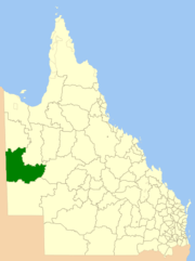 Location within Queensland | |||||||||||||||
| Population | 490 (2015)[1] | ||||||||||||||
| • Density | 0.00802/km2 (0.02077/sq mi) | ||||||||||||||
| Established | 1887 | ||||||||||||||
| Area | 61,102.0 km2 (23,591.6 sq mi) | ||||||||||||||
| Mayor | Rick Britton | ||||||||||||||
| Council seat | Boulia | ||||||||||||||
| Region | Central West Queensland | ||||||||||||||
| State electorate(s) | Gregory | ||||||||||||||
| Federal Division(s) | Kennedy | ||||||||||||||
|
| |||||||||||||||
| Website | Shire of Boulia | ||||||||||||||
| |||||||||||||||
The Shire of Boulia is a local government area in Central West Queensland, bordering the Northern Territory. Its administrative centre is in the town of Boulia.
It covers an area of 61,102.0 square kilometres (23,591.6 sq mi), and has existed as a local government entity since 1887. The main industry in the shire is beef production.
The shire is known for the unexplained phenomenon of the Min Min light, a light that has been reported to follow travellers in the area for some distance before disappearing.
History
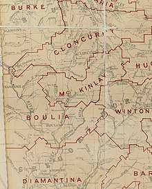
Map of Boulia Division and adjacent local government areas, March 1902
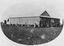
Boulia Divisional Board Hall, ca. 1900.
The Boulia Division was established on 24 September 1887.
On 31 March 1903, Boulia Division became the Shire of Boulia.
Towns and localities
The Shire of Boulia includes the following settlements:
Amenities
Boulia Shire Council operates a public library in Boulia.[2]
Population
| Year | Population |
|---|---|
| 1933 | 604 |
| 1947 | 676 |
| 1954 | 764 |
| 1961 | 833 |
| 1966 | 645 |
| 1971 | 755 |
| 1976 | 635 |
| 1981 | 600 |
| 1986 | 583 |
| 1991 | 575 |
| 1996 | 550 |
| 2001 | 643 |
| 2006 | 494 |
Chairmen and mayors
References
- ↑ "3218.0 – Regional Population Growth, Australia, 2014–15". Australian Bureau of Statistics. Retrieved 29 September 2016.
- ↑ "Boulia Shire Council". Public Libraries Connect. State Library of Queensland. 20 September 2016. Archived from the original on 6 February 2018. Retrieved 6 February 2018.
- ↑ Consolidated Index to Queensland Government Gazette 1859-1919. Queensland Family History Society. 2004. ISBN 1 876613 79 3.
- ↑ Pugh, Theophilus Parsons (1927). Pugh's Almanac for 1927. Retrieved 13 June 2014.
- ↑ "2008 Boulia Shire - Mayoral Election - Election Summary". Electoral Commission of Queensland. 31 August 2010. Retrieved 16 March 2017.
- ↑ "2012 Boulia Shire - Mayoral Election - Election Summary". Electoral Commission of Queensland. 28 May 2012. Retrieved 16 March 2017.
- ↑ "2016 Boulia Shire Council - Mayoral Election - Election Summary". Electoral Commission of Queensland. 19 April 2016. Retrieved 16 March 2017.
External links
- "Boulia and Boulia Shire". Queensland Places. Centre for the Government of Queensland, University of Queensland.
- "History of Boulia". Boulia Shire Council. Boulia Shire Council. Archived from the original on 2014-06-15.
- "Shire Timeline". Boulia Shire Council. Boulia Shire Council.
This article is issued from
Wikipedia.
The text is licensed under Creative Commons - Attribution - Sharealike.
Additional terms may apply for the media files.